|
Weather
Local Weather Forecasts |
| Announcements |
Up to 6 Inches of Snow Expected at Higher Elevations Through Thursday |
|
Posted by: thepinetree on 11/18/2013 07:00 PM
|
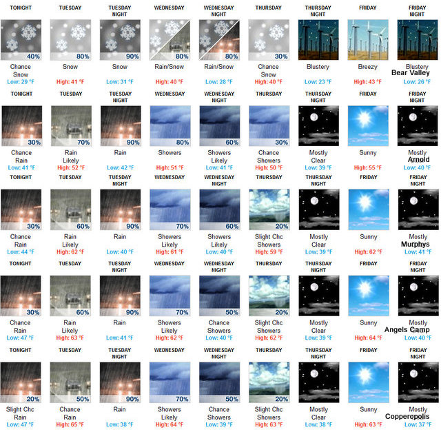
Bear Valley, CA...Tonight: Mostly cloudy. At lower elevations...a slight chance of rain in the evening...then a chance of rain after midnight. At higher elevations...a slight chance of rain in the evening...then a chance of rain and snow after midnight. Lows 25 to 39 higher elevations...36 to 44 lower elevations. Snow level 6500 to 7000 feet. Prevailing south winds up to 15 mph...except southwest 15 to 30 mph over ridges...
 |
|
Read More
| 0 Comments
|
|
Just a Hint Of A Storm Passing Through |
|
Posted by: thepinetree on 11/11/2013 04:02 PM
|
Arnold, CA...A few clouds but not much more from the system passing through according to the NWS. Tonight Mostly cloudy, with a low around 54. South wind around 6 mph becoming light and variable. Tuesday Mostly cloudy, then gradually becoming sunny, with a high near 65. East wind around 6 mph becoming west southwest in the afternoon. Tuesday Night Mostly clear, with a low around 50. North wind around 6 mph becoming east northeast in the evening....
 |
|
Read More
| 0 Comments
|
|
Snow On The Way Till Wednesday...Bear Valley Getting Ready for 2013/2014 Season |
|
Posted by: thepinetree on 10/28/2013 08:54 AM
|
Bear Valley, CA....There is white in the forecast until Wednesday. Bear Valley hopes to open by Thanksgiving if mother nature cooperates. They will be ready on the operations side from Winterfest onward. Today Snow showers. High near 32. South southwest wind 14 to 17 mph, with gusts as high as 26 mph. Chance of precipitation is 90%. Total daytime snow accumulation of 1 to 3 inches possible. Tonight Snow showers likely. Cloudy, with a low around 21. South southwest wind 13 to 15 mph, with gusts as high as 23 mph. Chance of precipitation is 60%. New snow accumulation of around an inch possible. Tuesday A 30 percent chance of snow showers, mainly before 11am. Partly sunny, with a high near 39. South wind around 7 mph. New snow accumulation of less than a half inch possible....

One of the great things about this area is the micro climates. Don't like the weather where you are. Just dive 30 minutes. The image above starts at Bear Valley at the top with Copperopolis on the bottom. |
|
Read More
| 0 Comments
|
|
Independence From Heat Wave On The Way!! Red Flag Warning Still in Effect for Today! |
|
Posted by: thepinetree on 07/03/2013 09:57 AM
|
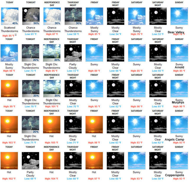
Arnold, CA...Today Mostly sunny, with a high near 94. Calm wind becoming west 5 to 7 mph in the afternoon. Tonight A 20 percent chance of showers and thunderstorms. Partly cloudy, with a low around 73. West wind 5 to 7 mph becoming calm. New rainfall amounts of less than a tenth of an inch, except higher amounts possible in thunderstorms. Independence Day A 20 percent chance of showers and thunderstorms before 11am. Mostly sunny, with a high near 95. East northeast wind 5 to 7 mph becoming west southwest in the morning. Thursday Night Partly cloudy, with a low around 72. West northwest wind around 8 mph becoming east northeast in the evening...
 |
|
Read More
| 0 Comments
|
|
Rain and Snow Today Then Sunny and Windy Skies Return This Week |
|
Posted by: John_Hamilton on 04/08/2013 09:26 AM
|
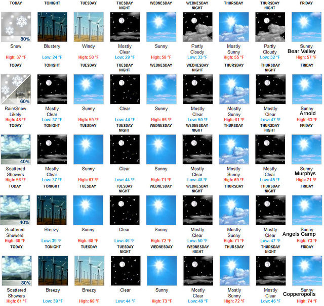
Bear Valley, CA...With some snow at higher elevations Mother Nature is still trying to add a bit to the snowpack totals for this year. After today though it looks like spring will return. 7-DAY FORECAST Today Snow showers, mainly before 11am. High near 37. North northeast wind 11 to 14 mph, with gusts as high as 21 mph. Chance of precipitation is 80%. Total daytime snow accumulation of less than one inch possible. Tonight Partly cloudy, with a low around 24. Blustery, with a east northeast wind 13 to 22 mph, with gusts as high as 33 mph. Tuesday Sunny, with a high near 50. Windy, with a east northeast wind 27 to 32 mph decreasing to 17 to 22 mph in the afternoon. Winds could gust as high as 48 mph. Tuesday Night Mostly clear, with a low around 29. East northeast wind 17 to 20 mph, with gusts as high as 30 mph...
|
|
Read More
| 0 Comments
|
|
Winter Returns This Week. Low Snow Starting Tomorrow |
|
Posted by: thepinetree on 02/18/2013 10:34 AM
|
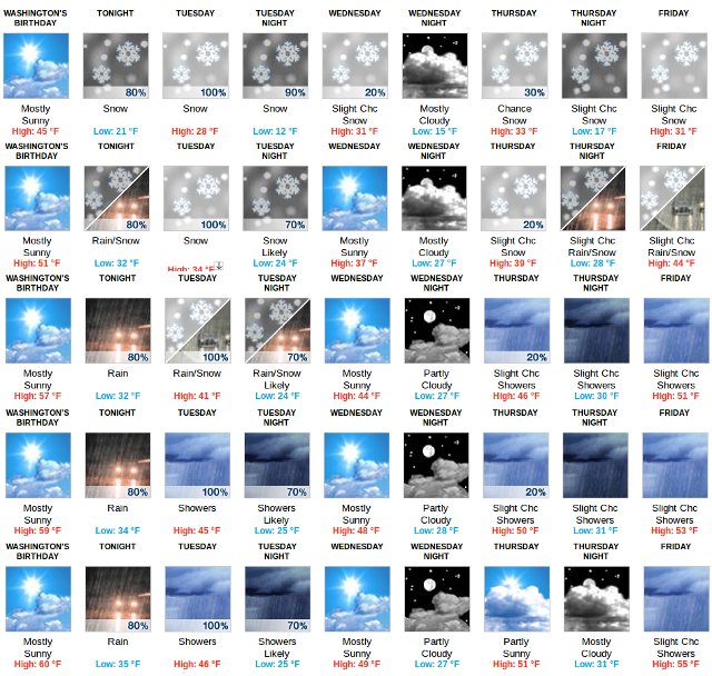
Bear Valley, CA...Winter returns tomorrow with cold temps and snow down to the 2,000ft level. Hopefully the systems will bring a bit more moisture than is forecast. A winter storm warning has been issued for Tuesday and Wednesday and is enclosed below the 7-Day forecast. Washington's Birthday Mostly sunny, with a high near 45. Light and variable wind becoming south southwest 11 to 16 mph in the morning. Winds could gust as high as 24 mph. Tonight Snow, mainly after 4am. Low around 21. South wind 8 to 13 mph, with gusts as high as 20 mph. Chance of precipitation is 80%. New snow accumulation of less than one inch possible. Tuesday Snow showers. High near 28. South southwest wind around 17 mph, with gusts as high as 29 mph. Chance of precipitation is 100%. New snow accumulation of 4 to 8 inches possible. Tuesday Night Snow showers, mainly before 10pm. Low around 12. Southwest wind 5 to 9 mph becoming calm in the evening. Chance of precipitation is 90%. New snow accumulation of 1 to 2 inches possible....
 |
|
Read More
| 0 Comments
|
|
Clear Days and Modest Warming Trend This Week |
|
Posted by: John_Hamilton on 01/12/2013 01:06 PM
|
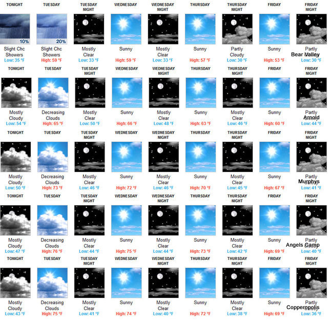
Murphys, CA...This Afternoon Mostly sunny, with a high near 39. West wind around 6 mph. Tonight Partly cloudy, with a low around 20. East northeast wind 3 to 7 mph. Sunday Sunny, with a high near 41. East northeast wind 5 to 7 mph becoming west southwest in the morning. Sunday Night Mostly clear, with a low around 24. Light and variable wind. Monday Sunny, with a high near 44. East northeast wind around 6 mph becoming west in the morning. Monday Night Mostly clear, with a low around 28. Tuesday Sunny, with a high near 52...
The Graphic Below Starts at Bear Valley then Arnold, Murphys, Angels Camp & Copperopolis to show Weather Changes by Elevation.
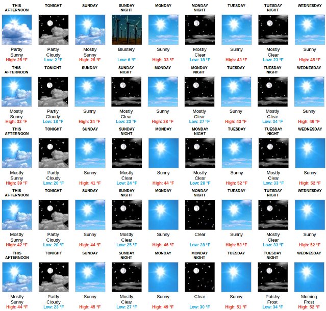
Click Above for Our Weather and Road Condition Page with Always the Latest Info |
|
Read More
| 0 Comments
|
|
The Next Storm System is Starting Winter Off White! Obligatory Warnings and Hazardous Outlooks Enclosed as Well |
|
Posted by: John_Hamilton on 12/21/2012 05:24 PM
|
Bear Valley, CA...The next storm system is upon us now. It looks like it will be bringing a White Christmas all the way to Christmas. Then you can unpack all your snow toys and go play. On a serious note. Please be prepared for at least a couple of days if your car gets stuck or stranded. The forecast through Christmas. Today... Late Afternoon Rain and snow showers. Snow level 4500 feet. Steady temperature around 37. Southeast wind around 13 mph, with gusts as high as 21 mph. Chance of precipitation is 100%. Little or no snow accumulation expected. Tonight Rain and snow. Snow level 4400 feet. Steady temperature around 36. Southeast wind 11 to 15 mph, with gusts as high as 23 mph. Chance of precipitation is 100%. Little or no snow accumulation expected. Saturday Rain showers before 5pm, then rain and snow showers. Some thunder is also possible. Snow level 4700 feet. Temperature falling to around 31 by noon. South southeast wind 14 to 16 mph, with gusts as high as 24 mph. Chance of precipitation is 100%. Little or no snow accumulation expected...
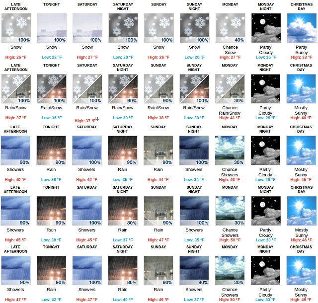
The Graphic Above Starts at Bear Valley and drops to Arnold, Murphys, Angels Camp and Copperopolis. Our hope is it will give a quick weather indicator by elevation. |
|
Read More
| 0 Comments
|
|
Season's First Winter Stom Moving in Sunday Night |
|
Posted by: thepinetree on 10/20/2012 10:50 AM
|
Bear Valley, CA...The first significant winter storm of the season will move into our area Sunday night. Between Sunday night and Early Tuesday up to 1/2 inch of rain at lower elevations. Above 5,500 feet 6 - 9 inches of snow and up to a foot at the highest elevations is possible. Wind gusts of up to 50 mph are possible over the ridges. The storm warning and special weather statement from the National Weather Service is enclosed...
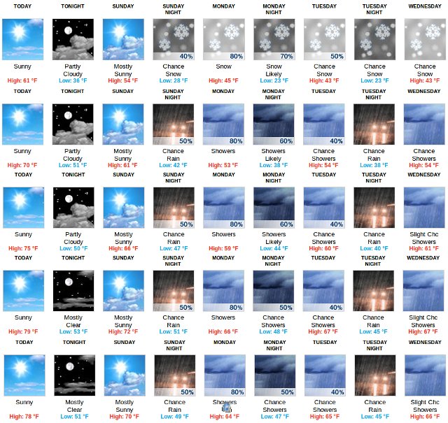
The graphic above should give you a good indication of weather at the different elevations in the county. It starts at Bear Valley and drops to Arnold, Murphys, Angels Camp and Copperopolis. |
|
Read More
| 0 Comments
|
|
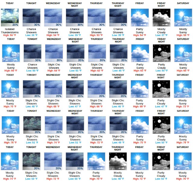
Showers in the Forecast This Week |
|
Posted by: thepinetree on 10/09/2012 09:12 AM
|
Murphys, CA...Today Mostly sunny, with a high near 70. Light and variable wind becoming west southwest 5 to 9 mph in the morning. Tonight A 20 percent chance of showers after 11pm. Mostly cloudy, with a low around 48. West wind 5 to 8 mph becoming north northeast after midnight. Wednesday A 20 percent chance of showers. Partly sunny, with a high near 68. Light and variable wind becoming west southwest 5 to 8 mph in the afternoon. Wednesday Night A 20 percent chance of showers before 11pm. Mostly cloudy, with a low around 47. North northwest wind 6 to 8 mph. Thursday A 20 percent chance of showers after 11am. Partly sunny, with a high near 66. Northeast wind 5 to 8 mph becoming west southwest in the morning. Thursday Night A 20 percent chance of showers before 11pm. Mostly cloudy, with a low around 46...
 |
|
Read More
| 0 Comments
|
|
|
|
|


