| Announcements |
Ya You Betcha...More Snow On The Way |
|
Posted by: thepinetree on 02/24/2010 07:09 PM
|
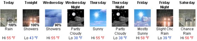
Bear Valley, CA...The morning we took a run up to about 8,000ft in the Bear Valley area at the end of SR207, at the Bear Valley Bus lot, to see what snow accumulation there was from the first wave of the latest storm systems. Bear Valley has been very conservative with their snow reports as they had reported about 6 inches of new snow and in many places there was easily a foot or more. NWS is reporting that tomorrow should be fairly quiet but on Friday we should see another wave that should bring us another foot or more....

The latest weather report is enclosed.. |
|
Read More
|
|
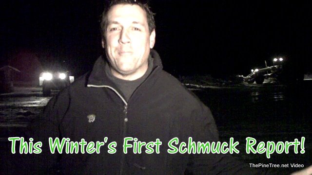
Saturday Morning Schmuck Report |
|
Posted by: thepinetree on 01/23/2010 11:51 PM
|
Bear Valley, CA...Saturday morning we checked in with the Bear Valley crew to see how they fared under the onslaught of snow last week. They made it through and from the looks of the full parking lots Bear Valley was filled with powder freaks in search of bottomless powder. Bear Valley ended up getting about 9 feet of new snow this week...
 |
|
Read More
| 0 Comments
|
|
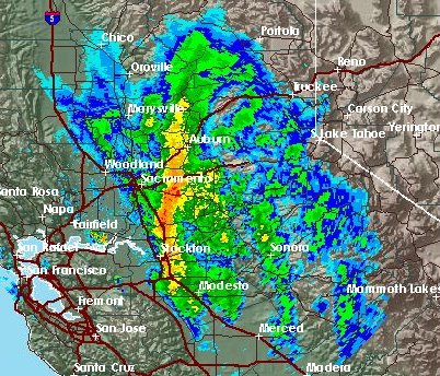
Another Storm Wave Rumbles Through |
|
Posted by: thepinetree on 01/21/2010 10:50 PM
|
Avery, CA...Our area is getting pounded by another storm wave that is making it's way east. The latest advisories are enclosed and the latest radar image is below.
 |
|
Read More
| 0 Comments
|
|
Eye of The Storm? |
|
Posted by: thepinetree on 01/21/2010 09:15 AM
|
Avery, CA...The latest radar images show the bulk of activity just to the north and south of Calaveras County. We should get some activity this afternoon but we may miss the brunt of this wave. The latest weather info and road conditions are always on our weather page. The Murphys forecast is enclosed...
 |
|
Read More
| 0 Comments
|
|
Heavy Winter Storm to Bring Welcome Snow To High Country |
|
Posted by: thepinetree on 01/12/2010 05:46 AM
|
Avery, CA...The first significantly wet winter storm in several weeks is expected to start rolling through soon. From the National Weather Service is the forecast for higher elevations....Today: Snow. High near 37. Breezy, with a south wind between 14 and 22 mph, with gusts as high as 30 mph. Chance of precipitation is 100%. Total daytime snow accumulation of 5 to 9 inches possible...
Above is graphics for lower and higher elevations for this storm... |
|
Read More
| 0 Comments
|
|
Lot's of Fresh New Snow in Bear Valley! |
|
Posted by: Kim_Hamilton on 12/21/2009 11:05 PM
|
Bear Valley, CA...The latest round of storms is bringing an early Christmas present to Bear Valley. So pack your bags and wax your sticks & boards and make plans to head on up to our Winter Wonderland for your holiday season! By the time this latest system rolls through the sierra's, we should have another foot of white stuff. We sent our intrepid reporter out into the cold to see what the conditions looked like this eve......
Video Enclosed... |
|
Read More
|
|
Another Weather System On The Way |
|
Posted by: thepinetree on 12/09/2009 02:57 PM
|
Murphys, CA...Another system is on it's way that is quite a bit warmer than the last one that is still wreaking havoc on the local roadways. According to the National Weather Service we should start seeing precipitation tomorrow....
The NWS Bear Valley Graphic is above. We always have the latest road and weather conditions on our weather page... |
|
Read More
|
|
Latest Schmuck Weather Report with John Hamilton |
|
Posted by: Kim_Hamilton on 02/06/2009 08:32 AM
|
Bear Valley, CA...We just sent one of our lowly field corespondents out into the elements for our current Schmuck Report so we could video their pain and shivering for your enjoyment. It is snowing hard right now with about 6 inches of snow accumulation so far with snow in the forecast as far out as the radar can see. Tomorrow looks to be a very light day so it will be a perfect day to come up and play! Video and the latest National Weather Service Forecast is enclosed...
  |
|
Read More
|
|
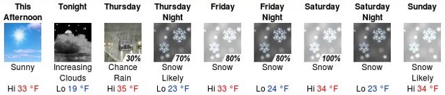
Snow Could Fall as Low as 6500' by Sunday Morning....Moderate to Heavy Snow Accumulations Likely Above 8000' Today |
|
Posted by: Kim_Hamilton on 11/01/2008 01:03 PM
|
There is a Winter storm warning in effect through the weekend through Monday. Cold and Wintery conditions returning to the highest elevations of the sierra. A series of systems will move across Northern California through Monday. These systems will bring periods of heavy rain and higher elevation snow to the Sierra Nevada. Snow levels will remain above 8000' through today. However, cooler air will slowly move into the region tonight, gradually lowering snow levels to around 6500' by Sunday morning. This early season storm will bring enough cold air and moisture to produce significant snowfall above 8000' through Sunday morning affecting some of the higher elevation passes, such as Sonora, Ebbetts and Carson Pass....
 |
|
Read More
| 0 Comments
|
|
Excessive Heat Watch for This Week..Temps Could Reach 113 Degrees in Angels Camp on Wednesday |
|
Posted by: Anonymous on 07/07/2008 11:56 PM
|
The National Weather Service is Stating there will be an "Excessive Heat Watch" for the next several days for portions of Northern California. Strong high pressure building over the area will result in near record to record temperatures over portions of interior Northern California over the next several days. Over the next several days, in addition, northerly wind will help reduce smoke in the the northern Sacramento and surrounding mountains allowing for greater heating during the day and warmer temps overnight. Wednesday is expected to be the hottest day with a gradual decrease in heat through the remainder of the week.....

|
|
Read More
| 0 Comments
|
|


