|
Traffic and Fire
Traffic & Fire Updates |
| Announcements |
The Big Creek TCU Fire Update...204 Acres, Evacuations Lifted, 35% Contained |
|
Posted by: thepinetree on 07/31/2015 02:09 PM
|
Groveland, CA...Current Situation: Acreage and containment continue holding steady since yesterday, but the extreme and historically dry fuel conditions remain a serious concern. With frequent spotting, this fire still remains a threat to firefighters and residents. Motorists driving in the area of the fire, especially on Highway 120, are asked to exercise great caution to avoid fire equipment and crews. Evacuations: Lifted at 6 p.m. 7-30-15, and residents were allowed to return to their homes.
 |
|
Read More
| 0 Comments
|
|
CAL FIRE and the USFS Announce Arrest & Cause of Big Creek Fire |
|
Posted by: thepinetree on 07/31/2015 02:15 PM
|
San Andreas – On Thursday, July 30th the cause of the Big Creek Fire was determined to be an escaped debris fire. A suspect was identified and at 6:00 p.m. an arrest was made in connection with the start of the fire. Lisa Ann Vilmur was arrested and booked into Tuolumne County Jail for one count of recklessly causing a fire, a felony violation of Penal Code § 452(c). Her bail has been set in the amount of $100,000...
 |
|
Read More
| 0 Comments
|
|
Big Creek Fire TCU Incident Update |
|
Posted by: thepinetree on 07/30/2015 03:50 PM
|
Groveland, CA...The increase in fire acreage is the result of better mapping. Fire fighters are working hard to construct containment lines around the fire even as conditions deteriorate with this afternoon’s rising air temperatures and wind speed. The surrounding drought-stressed forest with its thousands of dead trees has created an unprecedented danger to firefighters and residents alike. Frequent spot fires across the line into this dense, dry, heavy timber are major challenges, raising the possibility of steadily worsening fire activity. Power lines in the area have been de-energized at CAL FIRE’s request to protect firefighter safety. The line will be re-energized upon CAL FIRE’s request. There’s been no damage to the distribution system in the area due to the fire.
   |
|
Read More
| 0 Comments
|
|
Ebbetts Pass Scenic Byway Still Scenic After Washington Fire (Video) |
|
Posted by: thepinetree on 07/11/2015 01:44 PM
|
Markleeville, CA...Last weekend we had to drop an offspring for summer camp and thought it would be a good time to take a quick drive over Ebbetts Pass and to see how the Markleeville area looked after the over 15,000 acre Washington fire. We started taking shots in Bear Valley, Lake Alpine, Mosquito Lake Is At the 3:29 point, Hermit Valley and more before we got to the fire area. The Fire closed Hwy 4 and Hwy 89 for almost a week. The Hwy 4 area actually looks pretty good. Some burned areas but it looked like it was fairly fast moving in these areas and some of the trees will probably survive...
Ebbetts Pass Drive In HD |
|
Read More
| 0 Comments
|
|
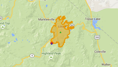
Fire Update...Washington Fire Reaches 37% Containment & Hwy 4 Now Open |
|
Posted by: thepinetree on 06/28/2015 07:18 PM
|
Markleeville, CA...Fire crews continued to increase the percent containment near Markleeville as they mopped up and patrolled the fire perimeter throughout the day. Hotshot crews on the eastern fire edge will continue to construct direct handline in steep and rocky terrain while being supported from the air with water-dropping helicopters. Light precipitation occurred over the northeastern section of the fire yesterday afternoon aiding in suppression activities.
 |
|
Read More
| 0 Comments
|
|
“If you fly, we can’t!” Drones Make It Unsafe For Fire Fighting Aircraft |
|
Posted by: thepinetree on 06/27/2015 06:15 AM
|
Monterey, CA – CAL FIRE has reported several instances of unmanned aircraft systems (UAS), otherwise known has Hobby Drones, flying in the vicinity of the Lake fire in San Bernardino County. The intrusion of these drones in the air space of firefighting aircraft resulted in all air operations being suspended until the drones were located and grounded. CAL FIRE San Benito-Monterey Unit would like to remind everyone that intrusion of the air space around a fire incident is highly dangerous to firefighting aircraft and firefighters on the ground. Here are a few keep points to remember regarding the critical air space around a fire incident.

|
|
Read More
| 0 Comments
|
|
Making Progress On Washington Fire...Hwy 4 Still Closed But Bear Valley, Lake Alpine Areas Open & Largely Smoke Free |
|
Posted by: thepinetree on 06/26/2015 08:48 AM
|
Markleeville, CA...Firefighters on the Washington Fire, 3 miles south of Markleeville, California continued to optimize lower wind conditions to increase containment. Significant progress has been made towards containing the western flank of the fire south of Markleeville. The fire has burned 16,490 acres and is 15 percent contained. The reduction in the reported fire size is due to more accurate mapping. The fire was most active overnight and today on the southern flank west of Wolf Creek Meadows in the Carson Iceberg Wilderness.
 |
|
Read More
| 0 Comments
|
|
Crews Making Progress On Washington Fire..Bear Valley & Lake Alpine Areas Open |
|
Posted by: thepinetree on 06/25/2015 11:47 AM
|
Markleeville, CA...Fire fighters continued to make progress on the Washington Fire, 8 miles south of Markleeville, California. The Bear Valley & Lake Alpine areas are open and largely smoke free. The fire which began last Friday has burned 17,205 acres and is 10 percent contained. For the safety of the public and due to fire suppression activities, Highways 4 and 89 in the Monitor and Ebbetts Pass areas remain closed. Several campgrounds along Highway 4 south of Markleeville as well as the Turtle Rock and Indian Creek campgrounds north of Markleeville remain closed. The Pacific Crest Trail remains open. Markleeville residents are under an evacuation advisory issued by Alpine County Sherriff’s office. No mandatory evacuations are in effect at this time...
 |
|
Read More
| 0 Comments
|
|
Yosemite Fire Update – June 12, 2015 #1.1 |
|
Posted by: thepinetree on 06/12/2015 10:05 PM
|
Yosemite, CA...Active Fires being monitored for multiple objectives: The current fires were started during the recent thunderstorms over the Sierra Nevada Mountains and Yosemite since early June. Precipitation associated with the recent lightning caused fires has put some out. The national weather service is predicting continued thunderstorm activity through the weekend at the Sierra Crest. All the fires are being monitored by Yosemite National Park firefighters.

|
|
Read More
| 0 Comments
|
|
Fire Update...Glencoe Area Fire Quickly Contained |
|
Posted by: thepinetree on 06/10/2015 02:23 AM
|
Glencoe, CA....On the afternoon of June 8th, there was a full wildland response to a vegetation fire on Hwy 26 in Glencoe. Firefighters made quick work of the blaze and kept it to a large spot fire. Details are enclosed...
 |
|
Read More
| 0 Comments
|
|
|
|
|


