|
Posted by: thepinetree on 01/20/2024 01:54 PM
Updated by: thepinetree on 01/20/2024 01:54 PM
Expires: 01/01/2029 12:00 AM
:
Winter Storm Warnings for Mountains & Flood Watch for Mother Lode
Arnold, CA...Detailed forecast from the National Weather Service for West Slope Northern Sierra Nevada. Tonight, At lower elevations, rain showers. At higher elevations, rain and snow showers until early morning, then heavy rain and snow showers likely late in the night. Colder. Lows 23 to 38 higher elevations...34 to 44 lower elevations. No snow accumulation lower elevations...1 to 7 inches higher elevations. Snow level 6500 feet. Prevailing south winds 10 to 20 mph with gusts to around 35 mph. Over ridges, prevailing southwest winds 20 to 35 mph decreasing to 15 to 25 mph after midnight.
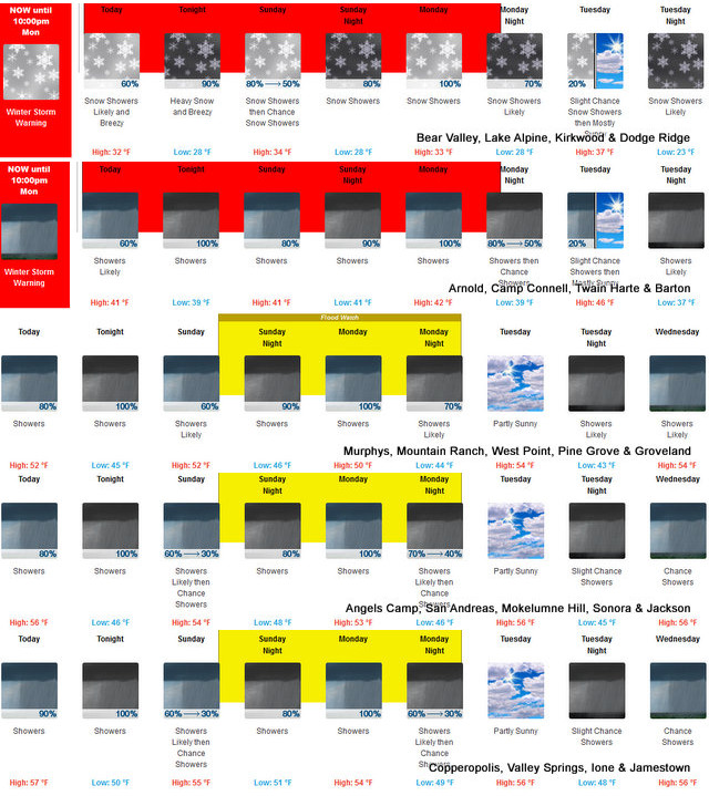
Sunday
At lower elevations, rain showers likely in the morning, then a chance of rain showers in the afternoon. At higher elevations, rain and snow showers likely. Highs 29 to 44 higher elevations...41 to 51 lower elevations. No snow accumulation lower elevations...2 to 4 inches higher elevations. Snow level 6500 feet. Prevailing south winds 5 to 15 mph.
Sunday Night
At lower elevations, rain showers. At higher elevations, rain showers and a chance of snow showers in the evening, then rain and snow showers after midnight. Lows 24 to 39 higher elevations...35 to 45 lower elevations. No snow accumulation lower elevations...up to 2 inches higher elevations. Snow level 6500 feet. Prevailing south winds 10 to 20 mph.
Monday
Rain and snow showers. Highs 29 to 44 higher elevations...40 to 48 lower elevations. No snow accumulation lower elevations...3 to 6 inches higher elevations. Snow level 6500 feet. Prevailing south winds 10 to 20 mph.
Monday Night
Mostly cloudy. Rain and snow showers likely in the evening, then a chance of rain and snow showers after midnight. Lows 21 to 36 higher elevations...33 to 43 lower elevations. No snow accumulation lower elevations...up to 3 inches higher elevations. Snow level 6500 feet. Prevailing south winds up to 10 mph.
Tuesday
Mostly cloudy with a slight chance of rain and snow showers. Not as cool. Highs 37 to 52.
Tuesday Night
Mostly cloudy with a chance of rain and snow showers. Lows 24 to 39.
Wednesday
Rain and snow showers likely. Light snow accumulations possible. Highs 34 to 49.
Wednesday Night And Thursday
Mostly cloudy with a chance of rain and snow showers. Lows 24 to 39. Highs 36 to 51.
Thursday Night
Partly cloudy with a slight chance of rain and snow showers. Lows 25 to 40.
Friday
Partly cloudy with a slight chance of rain showers. Not as cool. Highs 40 to 55.
Friday Night And Saturday
Mostly cloudy with a slight chance of rain showers. Lows 30 to 45. Highs 42 to 57.
Detailed forecast for
Motherlode
Tonight
Rain showers and a slight chance of thunderstorms early in the evening, then rain showers in the late evening and overnight. Lows 40 to 50. Prevailing south winds 5 to 15 mph.
Sunday
Mostly cloudy. Rain showers likely in the morning, then a chance of rain showers in the afternoon. Highs 46 to 58. Prevailing southeast winds 5 to 15 mph.
Sunday Night
Rain showers. Lows 41 to 51. Prevailing southeast winds 5 to 15 mph with gusts to around 30 mph.
Monday
Rain showers. Highs 46 to 56. Prevailing southeast winds 5 to 15 mph.
Monday Night
Mostly cloudy. Rain showers likely in the evening, then a chance of rain showers after midnight. Lows 38 to 48. Prevailing southeast winds up to 10 mph.
Tuesday
Mostly cloudy with a slight chance of rain showers. Highs 52 to 60.
Tuesday Night
Mostly cloudy with a chance of rain showers. Lows 39 to 47.
Wednesday
Mostly cloudy with rain showers likely. Highs 47 to 57.
Wednesday Night And Thursday
Mostly cloudy with a chance of rain showers. Lows 38 to 46. Highs 51 to 61.
Thursday Night And Friday
Partly cloudy with a slight chance of rain showers. Lows 38 to 46. Highs 54 to 62.
Friday Night And Saturday
Mostly cloudy with a slight chance of rain showers. Lows 42 to 48. Highs 56 to 64.
weather.gov
National Weather Service
Watches, Warnings & Advisories
Go to the NOAA Homepage
NWS Homepage
Local weather forecast by "City, St" or zip code
One product issued by NWS for: 11 Miles WSW Ebbets Pass CA
Winter Storm Warning
URGENT - WINTER WEATHER MESSAGE
National Weather Service Sacramento CA
1221 PM PST Sat Jan 20 2024
CAZ068-069-211400-
/O.CON.KSTO.WS.W.0005.000000T0000Z-240123T0600Z/
Western Plumas County/Lassen Park-
West Slope Northern Sierra Nevada-
Including the cities of Chester, Quincy, and Blue Canyon
1221 PM PST Sat Jan 20 2024
...WINTER STORM WARNING REMAINS IN EFFECT UNTIL 10 PM PST
MONDAY...
* WHAT...Periods of heavy snow. 8 to 16 inches between 6000 and
7000 feet, with 1 to 2 feet above 7000 feet. Winds gusting as
high as 45 mph.
* WHERE...Western Plumas County/Lassen Park and West Slope
Northern Sierra Nevada including Interstate 80 over Donner
Pass, Highway 50 over Echo Summit and Highway 88 over Carson
Pass.
* WHEN...Until 10 PM PST Monday.
* IMPACTS...Travel could be very difficult to impossible. Gusty
winds could bring down tree branches.
* ADDITIONAL DETAILS...Heavy, wet snow expected with this system. Snow
levels 6000 to 7000 feet today, briefly down to 5500 feet
Sunday morning, then rising to 6500 to 7500 feet Sunday evening.
Heaviest snow tonight and again on Monday.
PRECAUTIONARY/PREPAREDNESS ACTIONS...
If you must travel, keep an extra flashlight, food, and water in
your vehicle in case of an emergency.
The latest road conditions for the state you are calling from can
be obtained by calling 5 1 1.
Flood Watch
Flood Watch
National Weather Service Sacramento CA
1242 PM PST Sat Jan 20 2024
CAZ015>017-063-066-067-211400-
/O.CON.KSTO.FA.A.0001.240122T0000Z-240123T1200Z/
/00000.0.ER.000000T0000Z.000000T0000Z.000000T0000Z.OO/
Northern Sacramento Valley-Central Sacramento Valley-Southern
Sacramento Valley-Mountains Southwestern Shasta County to Western
Colusa County-Northeast Foothills/Sacramento Valley-Motherlode-
Including the cities of Marysville/Yuba City, Sacramento, Alder
Springs, Oroville, Grass Valley, Redding, Red Bluff, Jackson,
Paradise, and Chico
1242 PM PST Sat Jan 20 2024
...FLOOD WATCH REMAINS IN EFFECT FROM SUNDAY AFTERNOON THROUGH LATE
MONDAY NIGHT...
* WHAT...Flooding caused by excessive rainfall continues to be
possible.
* WHERE...A portion of northern California, including the following
areas, Central Sacramento Valley, Motherlode, Mountains
Southwestern Shasta County to Western Colusa County, Northeast
Foothills/Sacramento Valley, Northern Sacramento Valley and
Southern Sacramento Valley.
* WHEN...From Sunday afternoon through late Monday night.
* IMPACTS...Excessive runoff may result in flooding of rivers,
creeks, streams, and other low-lying and flood-prone locations.
Creeks and streams may rise out of their banks. Flooding may occur
in poor drainage and urban areas. Low-water crossings may be
flooded. Storm drains and ditches may become clogged with debris.
* ADDITIONAL DETAILS...
- Urban and small stream flooding from prolonged heavy rain
through Monday. Cottonwood and Cow creeks over Shasta county
and Battle creek over Butte county may be at higher risk for
flooding.
- http://www.weather.gov/safety/flood
PRECAUTIONARY/PREPAREDNESS ACTIONS...
You should monitor later forecasts and be alert for possible Flood
Warnings. Those living in areas prone to flooding should be prepared
to take action should flooding develop.
&&
|
| Comments - Make a comment |
| The comments are owned by the poster. We are not responsible for its content. We value free speech but remember this is a public forum and we hope that people would use common sense and decency. If you see an offensive comment please email us at news@thepinetree.net
No Subject
Posted on: 2024-01-20 15:07:35
By: Anonymous
|
|
Just received a courtesy call from PG&E power will be going out at 4 pm for Calaveras County for high voltage emergency work
[Reply
]
|
Re:
Posted on: 2024-01-20 15:33:12
By: Anonymous
|
|
^You are a fuking liar!
[Reply
]
|
Re:
Posted on: 2024-01-20 16:13:13
By: Anonymous
|
|
That's not nice, Fuk You.
[Reply
]
|
Re:
Posted on: 2024-01-20 16:17:32
By: Anonymous
|
|
1st poster isn't the brightest color crayon in the box...must be a dumba 💩
[Reply
]
|
Re:
Posted on: 2024-01-20 16:31:57
By: Anonymous
|
|
Yup, power's off. I'll be darned, you're right.
I bet nobody has ever told you you're right before. HAHAHAHAHOHOHOHO
[Reply
]
|
|
| What's Related |
| These might interest you as well
Local News
Photo Albums
|
|
|


