|
Posted by: thepinetree on 08/19/2023 10:20 PM
Updated by: thepinetree on 08/19/2023 10:20 PM
Expires: 01/01/2028 12:00 AM
:
Hillary Bringing Thunderstorms, Rain Showers & More Our Way
Arnold, CA...Hillary Bringing Thunderstorms, Rain Showers & More Our Way. She made a noisy entrance this evening. Luckily we are not going to feel her full wrath.
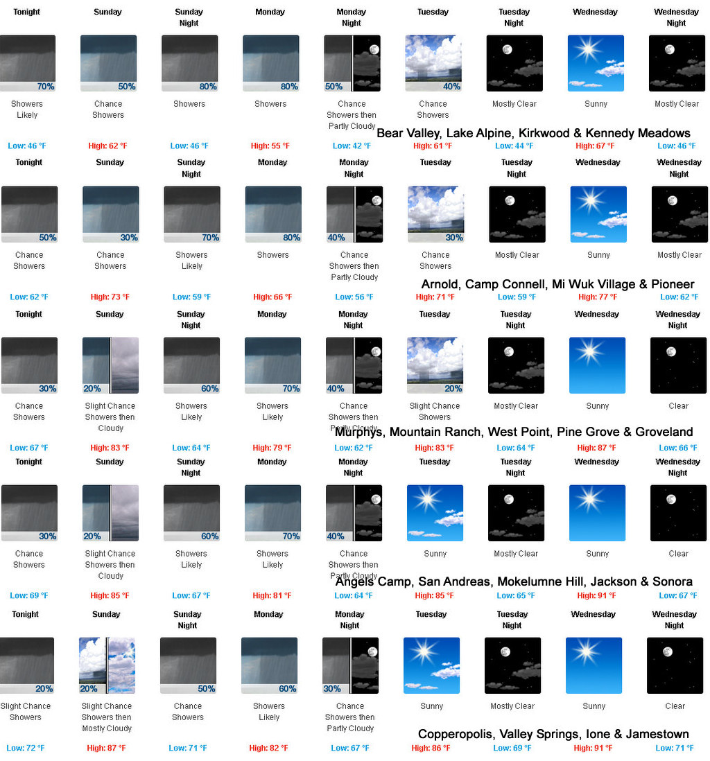

Detailed forecast for
West Slope Northern Sierra Nevada
Tonight
Mostly cloudy. A chance of showers and thunderstorms early in the evening, then a chance of rain showers and a slight chance of thunderstorms in the late evening and overnight. Cooler. Lows 44 to 59 higher elevations...54 to 68 lower elevations. Prevailing south winds up to 10 mph shifting to the east after midnight.
Sunday
Mostly cloudy. A chance of rain showers in the morning, then a chance of rain showers and a slight chance of thunderstorms in the afternoon. Highs 57 to 72 higher elevations...73 to 83 lower elevations. Prevailing east winds up to 15 mph.
Sunday Night
Cloudy. A chance of rain showers and a slight chance of thunderstorms in the evening, then rain showers after midnight. Lows 42 to 57 higher elevations...52 to 64 lower elevations. Prevailing east winds 5 to 15 mph.
Monday
Rain showers in the morning, then rain showers and a slight chance of thunderstorms in the afternoon. Highs 51 to 66 higher elevations...65 to 75 lower elevations. Prevailing south winds 5 to 15 mph.
Monday Night
Mostly cloudy with a chance of rain showers and a slight chance of thunderstorms in the evening, then partly cloudy with a slight chance of showers and thunderstorms after midnight. Colder. Lows 39 to 54 higher elevations...49 to 64 lower elevations. Prevailing southwest winds up to 10 mph shifting to the east after midnight.
Tuesday
Partly cloudy with a chance of rain showers. Warmer. Highs 61 to 76.
Tuesday Night
Mostly clear. Lows 45 to 60.
Wednesday And Wednesday Night
Clear. Highs 67 to 82. Lows 47 to 62.
Thursday And Thursday Night
Mostly clear. Highs 68 to 83. Lows 48 to 63.
Friday Through Saturday
Clear. Highs 68 to 83. Lows 48 to 63.
Detailed forecast for
Motherlode
Tonight
Mostly cloudy. A slight chance of thunderstorms early in the evening. A chance of rain showers in the evening, then a slight chance of rain showers after midnight. A slight chance of thunderstorms late in the night. Lows 63 to 73. Prevailing southwest winds up to 10 mph shifting to the east after midnight.
Sunday
Mostly cloudy. A slight chance of rain showers in the morning. Highs 78 to 90. Prevailing northeast winds up to 10 mph shifting to the west in the afternoon.
Sunday Night
Cloudy with a chance of rain showers. Lows 59 to 71. Prevailing north winds up to 10 mph shifting to the east after midnight.
Monday
Rain showers likely in the morning, then rain showers likely and a slight chance of thunderstorms in the afternoon. Highs 71 to 85. Prevailing south winds 5 to 15 mph.
Monday Night
Mostly cloudy with a chance of rain showers and a slight chance of thunderstorms in the evening, then partly cloudy with a slight chance of rain showers after midnight. Lows 57 to 67. Prevailing southwest winds up to 10 mph in the evening becoming light.
Tuesday
Partly cloudy with a slight chance of rain showers. Highs 76 to 88.
Tuesday Night
Clear. Lows 59 to 69.
Wednesday Through Saturday
Clear. Highs 82 to 96. Lows 59 to 71.
|
| Comments - Make a comment |
| The comments are owned by the poster. We are not responsible for its content. We value free speech but remember this is a public forum and we hope that people would use common sense and decency. If you see an offensive comment please email us at news@thepinetree.net
|
| What's Related |
| These might interest you as well
Local News
Photo Albums
|
|
|


