|
Posted by: thepinetree on 03/19/2023 10:57 AM
Updated by: thepinetree on 03/19/2023 10:57 AM
Expires: 01/01/2028 12:00 AM
:
Winter Returns, Snow Level Dropping to 4,000 Feet Monday & Storms Continue
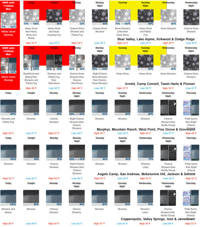
Arnold, CA...Following are the latest NWS Forecasts for the West Slope & Mother Lode. Detailed forecast for West Slope Northern Sierra Nevada. Today, At lower elevations, rain showers, patchy fog late in the morning. Areas of fog in the afternoon. At higher elevations, a chance of rain and snow showers early in the morning, then heavy rain and snow showers in the late morning and afternoon, areas of freezing fog late in the morning. Areas of fog in the late morning and afternoon. Areas of freezing fog late in the afternoon, areas of freezing fog late in the morning. Areas of fog in the late morning and afternoon. Areas of freezing fog late in the afternoon. Breezy. Highs 29 to 44 higher elevations... 39 to 49 lower elevations. No snow accumulation lower elevations...3 to 9 inches higher elevations. Snow level 6000 feet. Prevailing south winds 10 to 25 mph with gusts to around 40 mph.
Tonight
At lower elevations, rain showers in the evening, then rain showers and a slight chance of thunderstorms after midnight, rain showers through the night. A slight chance of thunderstorms after midnight. At higher elevations, heavy rain and snow showers, heavy rain and snow showers. Areas of fog and freezing fog through the night. Breezy, colder. Lows 19 to 34 higher elevations...32 to 40 lower elevations. No snow accumulation lower elevations...6 to 11 inches higher elevations. Snow level 6500 feet decreasing to 5500 feet after midnight. Prevailing southwest winds 10 to 25 mph.
Monday
Mostly cloudy. Patchy fog in the morning. A chance of rain and snow showers. Highs 28 to 43 higher elevations...40 to 50 lower elevations. Little or no snow accumulation lower elevations...1 to 2 inches higher elevations. Snow level 4000 feet. Prevailing southwest winds 5 to 15 mph with gusts to around 30 mph...except southwest 10 to 25 mph over ridges.
Monday Night
Mostly cloudy. A slight chance of rain and snow showers in the evening, then a chance of snow showers after midnight. Colder. Lows 14 to 29 higher elevations...27 to 37 lower elevations. Little or no snow accumulation lower elevations...up to 1 inch higher elevations. Snow level 4000 feet. Prevailing south winds up to 10 mph shifting to the southeast after midnight.
Tuesday
Snow showers likely in the morning, then heavy rain and snow showers in the afternoon. Highs 26 to 41 higher elevations...38 to 46 lower elevations. Snow accumulation up to 2 inches lower elevations...except 3 to 9 inches higher elevations. Snow level 4000 feet. Prevailing southeast winds up to 15 mph.
Tuesday Night
Heavy rain and snow showers. Moderate snow accumulations possible. Lows 20 to 35.
Wednesday
Snow showers likely. Moderate snow accumulations possible. Highs 27 to 42.
Wednesday Night And Thursday
Mostly cloudy with a chance of rain and snow showers. Lows 18 to 33. Highs 28 to 43.
Thursday Night
Rain and snow showers likely. Moderate snow accumulations possible. Lows 20 to 35.
Friday Through Saturday
Mostly cloudy with a chance of heavy snow showers. Highs 27 to 42. Lows 16 to 31.
Detailed forecast for
Motherlode
Today
Rain showers. Patchy fog in the late morning and afternoon. Breezy. Highs 45 to 57. Prevailing southeast winds 5 to 15 mph increasing to 15 to 25 mph in the afternoon.
Tonight
Patchy fog in the evening. Rain showers in the evening, then a chance of rain showers and a slight chance of thunderstorms after midnight. Lows 37 to 45. Prevailing south winds 5 to 15 mph with gusts to around 30 mph.
Monday
Mostly cloudy. A chance of rain showers in the morning, then a slight chance of rain showers in the afternoon. Highs 46 to 56. Prevailing south winds up to 10 mph.
Monday Night
Partly cloudy with a slight chance of rain showers in the evening, then mostly cloudy with a chance of rain showers after midnight. Lows 33 to 43. Prevailing south winds up to 10 mph in the evening becoming light.
Tuesday
Rain and snow showers likely in the morning, then rain showers in the afternoon. Highs 42 to 52. Little or no snow accumulation. Prevailing east winds up to 10 mph shifting to the south in the afternoon.
Tuesday Night
Rain showers. Lows 34 to 42.
Wednesday
Rain showers likely. Highs 40 to 52.
Wednesday Night Through Friday
Mostly cloudy with a chance of rain showers. Lows 34 to 43. Highs 41 to 56.
Friday Night
Mostly cloudy with a chance of rain and snow showers. Colder. Lows 27 to 35.
Saturday
Partly cloudy with a slight chance of rain and snow showers. Highs 43 to 55.
|
| Comments - Make a comment |
| The comments are owned by the poster. We are not responsible for its content. We value free speech but remember this is a public forum and we hope that people would use common sense and decency. If you see an offensive comment please email us at news@thepinetree.net
|
| What's Related |
| These might interest you as well
Photo Albums
Local News
- Big Trees Market Weekly Ad, Grocery, Produce, Meat & Deli Specials Thr...
- Big Trees Market Weekly Ad, Grocery, Produce, Meat & Deli Specials Thr...
- Bear Valley Music Festival is July 19th - August 4th! Get Your Tickets...
- Bear Valley Music Festival ~ CVB Feature
- Bear Valley Music Festival is July 19th - August 4th! Get Your Tickets...
- Big Trees Market Weekly Ad, Grocery, Produce, Meat & Deli Specials Thr...
- Big Trees Market Weekly Ad, Grocery, Produce, Meat & Deli Specials Thr...
- Repairs Completed on Hwy 4 Over Ebbetts Pass in Time for 43rd Annual D...
- Big Trees Market Weekly Ad, Grocery, Produce, Meat & Deli Specials Thr...
phpws Business Directory
Calendar
Web Pages
Link Manager
|
|
|


