|
Posted by: thepinetree on 02/26/2023 10:45 AM
Updated by: thepinetree on 02/26/2023 12:59 PM
Expires: 01/01/2028 12:00 AM
:
Up to Seven Feet of New Snow, High Winds & Snow Levels Down to Hwy 49 Levels Heading Our Way
Arnold, CA...More precipitation in many forms, wind & snow levels down to the 1,500 ft level are in our future. The latest detailed storm warnings, wind warnings & forecasts from the National Weather Service for the West Slope and Mother Lode are below...

Detailed forecast for
West Slope Northern Sierra Nevada
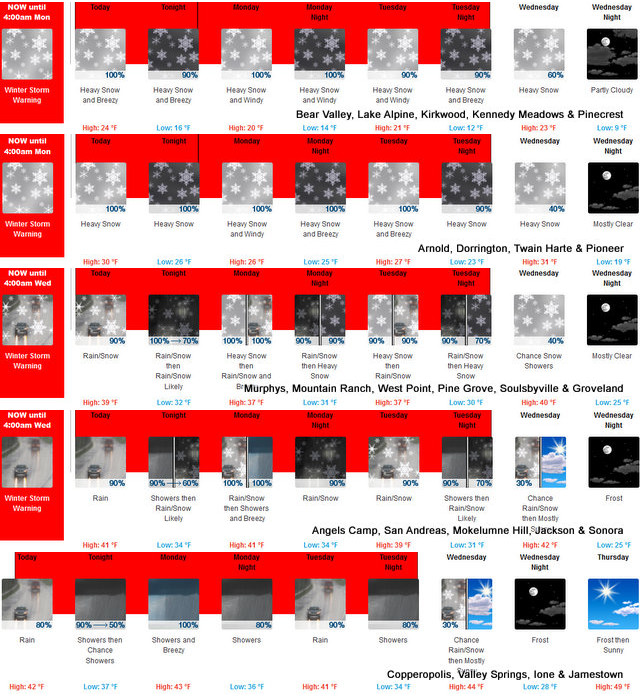
Today
Breezy. A chance of snow in the morning, then heavy snow early in the afternoon. Heavy snow showers late in the afternoon. Highs 19 to 34 higher elevations...30 to 38 lower elevations. Snow accumulation of 7 to 12 inches. Prevailing south winds 5 to 15 mph increasing to 15 to 25 mph in the afternoon. Gusts up to 40 mph.
Tonight
Heavy snow showers. Blowing snow after midnight. Windy. Visibility one quarter mile or less at times after midnight. Lows 10 to 25 higher elevations...23 to 31 lower elevations. Snow accumulation of 3 to 9 inches lower elevations... Except 9 to 14 inches higher elevations. Prevailing south winds 15 to 30 mph with gusts to around 50 mph. Over ridges, prevailing southwest winds 25 to 35 mph increasing to 30 to 45 mph after midnight.
Monday
Heavy snow likely in the morning, then heavy snow showers in the afternoon. Windy. Highs 15 to 30 higher elevations...27 to 35 lower elevations. Snow accumulation of 12 to 17 inches. Prevailing south winds 15 to 25 mph with gusts to around 45 mph increasing to 25 to 35 mph with gusts to around 65 mph in the afternoon. Over ridges, prevailing southwest winds 30 to 40 mph increasing to 30 to 50 mph with gusts to around 70 mph in the afternoon.
Monday Night
Heavy snow showers and a slight chance of thunderstorms in the evening, then heavy snow showers after midnight. Windy. Lows 10 to 25 higher elevations...23 to 31 lower elevations. Snow accumulation of 11 to 16 inches. Prevailing southwest winds 15 to 35 mph with gusts to around 60 mph. Over ridges, prevailing southwest winds 35 to 55 mph with gusts to around 70 mph decreasing to 30 to 45 mph after midnight.
Tuesday
Heavy snow in the morning, then heavy snow showers in the afternoon. Windy. Highs 16 to 31 higher elevations...28 to 36 lower elevations. Snow accumulation of 13 to 18 inches. Prevailing southwest winds 20 to 35 mph with gusts up to 45 mph increasing to 60 mph in the afternoon....except southwest 20 to 50 mph over ridges.
Tuesday Night
Heavy snow showers. Breezy. Heavy snow accumulations possible. Lows 11 to 26.
Wednesday
Mostly cloudy with a chance of heavy snow showers. Highs 22 to 37.
Wednesday Night And Thursday
Mostly clear. Lows 8 to 23. Highs 32 to 47.
Thursday Night And Friday
Mostly clear. Lows 15 to 30. Highs 33 to 48.
Friday Night
Mostly cloudy with a slight chance of snow. Lows 17 to 32.
Saturday
Mostly cloudy with a chance of heavy snow. Breezy. Highs 25 to 40.
Detailed forecast for
Motherlode
Today
Breezy. A chance of rain and snow in the morning, then rain and heavy snow early in the afternoon. Rain showers and snow showers late in the afternoon. Highs 34 to 44. Little or no snow accumulation lower elevations...1 to 7 inches higher elevations. Prevailing southeast winds 5 to 15 mph shifting to the south 10 to 25 mph in the afternoon.
Tonight
Rain and snow showers in the evening, then a chance of rain and snow showers after midnight. Lows 28 to 38. No snow accumulation lower elevations...2 to 4 inches higher elevations. Prevailing south winds 10 to 20 mph.
Monday
Rain and snow likely in the morning, then rain showers and heavy snow showers in the afternoon. Windy. Highs 31 to 45. Snow accumulation 2 to 4 inches lower elevations...except 4 to 10 inches higher elevations. Snow level 2000 feet. Prevailing southeast winds 5 to 15 mph shifting to the south 15 to 30 mph in the afternoon.
Monday Night
Rain showers, heavy snow showers and a slight chance of thunderstorms. Breezy. Lows 28 to 36. Snow accumulation up to 2 inches lower elevations...except 3 to 9 inches higher elevations. Snow level 2000 feet. Prevailing south winds 10 to 25 mph decreasing to 5 to 15 mph after midnight.
Tuesday
Heavy rain and snow in the morning, then rain showers and heavy snow showers in the afternoon. Breezy. Highs 33 to 43. Snow accumulation 3 to 5 inches lower elevations...except 6 to 12 inches higher elevations. Snow level 2000 feet. Prevailing south winds 10 to 25 mph.
Tuesday Night
Rain showers, heavy snow showers and a slight chance of thunderstorms. Heavy snow accumulations possible. Lows 25 to 35.
Wednesday
Partly cloudy with a chance of rain and snow showers. Highs 36 to 48.
Wednesday Night
Mostly clear. Widespread frost. Lows 22 to 28.
Thursday
Mostly sunny. Not as cool. Highs 41 to 53.
Thursday Night
Mostly clear. Areas of frost. Lows 27 to 33.
Friday
Mostly sunny. Highs 44 to 56.
Friday Night
Mostly cloudy with a slight chance of rain. Lows 30 to 38.
Saturday
Mostly cloudy with a chance of rain and snow. Highs 38 to 52.
Winter Storm Warning
URGENT - WINTER WEATHER MESSAGE
National Weather Service Sacramento CA
205 AM PST Sun Feb 26 2023
CAZ069-270000-
/O.CON.KSTO.WS.W.0007.230226T1800Z-230227T1200Z/
/O.CON.KSTO.BZ.W.0001.230227T1200Z-230301T1200Z/
West Slope Northern Sierra Nevada-
Including the city of Blue Canyon
205 AM PST Sun Feb 26 2023
...WINTER STORM WARNING REMAINS IN EFFECT FROM 10 AM THIS MORNING
TO 4 AM PST MONDAY...
...BLIZZARD WARNING REMAINS IN EFFECT FROM 4 AM MONDAY TO 4 AM
PST WEDNESDAY...
* WHAT...Heavy snow and strong winds expected. Blizzard conditions
Monday morning through Tuesday night. Total snow accumulations
of 3 to 7 feet. Winds gusting as high as 70 mph.
* WHERE...West Slope Northern Sierra Nevada including Interstate
80 over Donner Pass, Highway 50 over Echo Summit and Highway 88
over Carson Pass.
* WHEN...For the Winter Storm Warning, from 10 AM this morning
to 4 AM PST Monday. For the Blizzard Warning, from 4 AM Monday
to 4 AM PST Wednesday.
* IMPACTS...Travel will be extremely dangerous to impossible with
extended road closures likely. Blowing snow will cause white-
out conditions at times. Downed trees and tree limbs with power
outages are possible due to heavy snow and gusty winds.
PRECAUTIONARY/PREPAREDNESS ACTIONS...
If you must travel, keep an extra flashlight, food, and water in
your vehicle in case of an emergency.
Travel should be restricted to emergencies only. If you must
travel, have a winter survival kit with you. If you get stranded,
stay with your vehicle.
The latest road conditions for the state you are calling from can
be obtained by calling 5 1 1.
&&
$$
Blizzard Warning
URGENT - WINTER WEATHER MESSAGE
National Weather Service Sacramento CA
205 AM PST Sun Feb 26 2023
CAZ069-270000-
/O.CON.KSTO.WS.W.0007.230226T1800Z-230227T1200Z/
/O.CON.KSTO.BZ.W.0001.230227T1200Z-230301T1200Z/
West Slope Northern Sierra Nevada-
Including the city of Blue Canyon
205 AM PST Sun Feb 26 2023
...WINTER STORM WARNING REMAINS IN EFFECT FROM 10 AM THIS MORNING
TO 4 AM PST MONDAY...
...BLIZZARD WARNING REMAINS IN EFFECT FROM 4 AM MONDAY TO 4 AM
PST WEDNESDAY...
* WHAT...Heavy snow and strong winds expected. Blizzard conditions
Monday morning through Tuesday night. Total snow accumulations
of 3 to 7 feet. Winds gusting as high as 70 mph.
* WHERE...West Slope Northern Sierra Nevada including Interstate
80 over Donner Pass, Highway 50 over Echo Summit and Highway 88
over Carson Pass.
* WHEN...For the Winter Storm Warning, from 10 AM this morning
to 4 AM PST Monday. For the Blizzard Warning, from 4 AM Monday
to 4 AM PST Wednesday.
* IMPACTS...Travel will be extremely dangerous to impossible with
extended road closures likely. Blowing snow will cause white-
out conditions at times. Downed trees and tree limbs with power
outages are possible due to heavy snow and gusty winds.
PRECAUTIONARY/PREPAREDNESS ACTIONS...
If you must travel, keep an extra flashlight, food, and water in
your vehicle in case of an emergency.
Travel should be restricted to emergencies only. If you must
travel, have a winter survival kit with you. If you get stranded,
stay with your vehicle.
The latest road conditions for the state you are calling from can
be obtained by calling 5 1 1.
Winter Storm Warning
URGENT - WINTER WEATHER MESSAGE
National Weather Service Sacramento CA
205 AM PST Sun Feb 26 2023
CAZ067-270000-
/O.CON.KSTO.WS.W.0007.230226T1800Z-230301T1200Z/
Motherlode-
Including the cities of Grass Valley and Jackson
205 AM PST Sun Feb 26 2023
...WINTER STORM WARNING REMAINS IN EFFECT FROM 10 AM THIS MORNING
TO 4 AM PST WEDNESDAY...
* WHAT...Heavy snow expected. Total snow accumulations of 1 to 3
feet above 2000 feet. Lighter accumulations down to 1500 feet.
Winds gusting as high as 50 mph.
* WHERE...Motherlode.
* WHEN...From 10 AM this morning to 4 AM PST Wednesday.
* IMPACTS...Travel could be very difficult to impossible with
extended road closures. Downed trees and limbs with local power
outages are possible due to heavy snow and gusty winds.
* ADDITIONAL DETAILS...Snow levels 2500 to 3000 feet today
lowering to 1500 to 2000 feet Monday and Tuesday.
PRECAUTIONARY/PREPAREDNESS ACTIONS...
If you must travel, keep an extra flashlight, food, and water in
your vehicle in case of an emergency.
The latest road conditions for the state you are calling from can
be obtained by calling 5 1 1.
&&
$$
Wind Advisory
URGENT - WEATHER MESSAGE
National Weather Service Sacramento CA
205 AM PST Sun Feb 26 2023
CAZ019-067-270000-
/O.EXA.KSTO.WI.Y.0010.230227T1200Z-230228T0000Z/
Northern San Joaquin Valley-Motherlode-
Including the cities of Stockton, Modesto, Grass Valley,
and Jackson
205 AM PST Sun Feb 26 2023
...WIND ADVISORY IN EFFECT FROM 4 AM TO 4 PM PST MONDAY...
* WHAT...South winds 15 to 25 mph with gusts up to 40 mph
expected.
* WHERE...Northern San Joaquin Valley and Motherlode.
* WHEN...From 4 AM to 4 PM PST Monday.
* IMPACTS...Gusty winds could blow around unsecured objects.
Tree limbs could be blown down and a few power outages may
result.
* ADDITIONAL DETAILS...Strongest winds Monday afternoon.
PRECAUTIONARY/PREPAREDNESS ACTIONS...
Use extra caution when driving, especially if operating a high
profile vehicle. Secure outdoor objects.
|
| Comments - Make a comment |
| The comments are owned by the poster. We are not responsible for its content. We value free speech but remember this is a public forum and we hope that people would use common sense and decency. If you see an offensive comment please email us at news@thepinetree.net
No Subject
Posted on: 2023-02-26 13:26:50
By: Anonymous
|
|
Thank You Lisa for purchasing Chapel of the Pines 2023 Ford F 550 wood truck with dump bed. Maybe god will forgive your past sins. Maybe
[Reply
]
|
Re: sin
Posted on: 2023-02-26 13:43:21
By: Anonymous
|
|
Let he who is without sin cast the first stone.
You must also live in a glass house.
[Reply
]
|
Re: sin
Posted on: 2023-02-27 07:45:33
By: Anonymous
|
|
Go thump on your bible, signed Heathen
[Reply
]
|
No Subject
Posted on: 2023-02-26 18:15:10
By: Anonymous
|
|
Wow!!! Nice Truck! I want that......dump bed is a ++++
[Reply
]
|
Re:
Posted on: 2023-02-26 18:29:27
By: Anonymous
|
|
What sin & a truck have in common is BEYOND me!
[Reply
]
|
Re:
Posted on: 2023-02-27 07:48:12
By: Anonymous
|
|
Dumb Fuk do you know Lisa past?
[Reply
]
|
Re:
Posted on: 2023-02-27 07:51:45
By: Anonymous
|
|
Beyond me maybe that truck should be driven up your ass.
[Reply
]
|
Re:
Posted on: 2023-02-27 09:03:40
By: Anonymous
|
|
Is Lisa still bangin?
[Reply
]
|
|
| What's Related |
| These might interest you as well
Photo Albums
Local News
- Big Trees Market Weekly Ad, Grocery, Produce, Meat & Deli Specials Thr...
- Arnold Chevron & Deli, Eat Where the Locals Eat! Order Lunch Today at ...
- Uniquity Builders, Turning Your Dreams Into Reality Since 1985! Call 2...
- Big Trees Market Weekly Ad, Grocery, Produce, Meat & Deli Specials Thr...
- Over 2,000 PG&E Customers Powerless on Sunday Morning in Our Area (Upd...
- Another Real Estate Happy Ending from Better Altitude Properties
- 14.4 Million Reasons to Shop Local on Marketing Your Business! Buy Our...
- Your Dinner Awaits at Rossetti's @ The 19th Hole! Open Fri - Sun ...
- Chapel in the Pines Sunday Service, April 21, 2024
phpws Business Directory
Calendar
Web Pages
Link Manager
|
|
|


