Posted by: thepinetree on 01/03/2023 09:52 AM
Updated by: thepinetree on 01/03/2023 09:52 AM
Expires: 01/01/2028 12:00 AM
:
A Bit of a Break Today Then Winter Weather Watches, Flood & Wind Warnings Return
Arnold, CA...Detailed forecast from the National Weather Service for West Slope Northern Sierra Nevada. Today, Mostly cloudy. A slight chance of rain and snow showers early in the morning. Patchy fog in the morning. Highs 26 to 41 higher elevations...37 to 49 lower elevations. Little or no snow accumulation lower elevations...up to 1 inch higher elevations. Snow level 5000 feet. Prevailing south winds up to 10 mph with gusts to around 25 mph. Tonight, Partly cloudy in the evening then becoming mostly cloudy. Lows 16 to 31 higher elevations...29 to 39 lower elevations. Prevailing southeast winds up to 10 mph with gusts to around 25 mph.
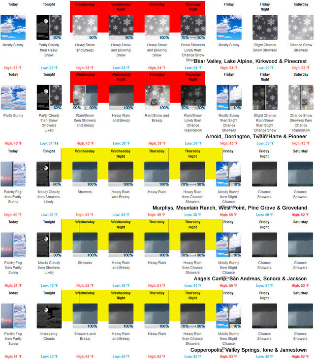

Wednesday
At lower elevations, rain and snow showers likely in the morning, then rain showers in the afternoon. At higher elevations, a chance of snow showers in the morning, then rain showers and heavy snow showers in the afternoon. Patchy blowing snow in the afternoon. Breezy. Not as cool. Visibility one quarter mile or less at times in the afternoon. Highs 31 to 46 higher elevations...42 to 52 lower elevations. Snow accumulation up to 1 inch lower elevations...except 3 to 8 inches higher elevations. Snow level 4500 feet increasing to 7000 feet in the afternoon. Prevailing southeast winds 5 to 15 mph with gusts to around 30 mph increasing to 15 to 25 mph with gusts to around 50 mph in the afternoon. Over ridges, prevailing south winds 15 to 25 mph increasing to 25 to 45 mph in the afternoon.
Wednesday Night
Rain showers and heavy snow showers. Blowing snow. Windy. Visibility one quarter mile or less at times. Lows 23 to 38 higher elevations...36 to 44 lower elevations. No snow accumulation lower elevations...4 to 10 inches higher elevations. Snow level 6500 feet. Prevailing south winds 20 to 30 mph with gusts to around 55 mph...except south 20 to 55 mph over ridges.
Thursday
Heavy rain and snow showers. Blowing snow in the morning. Areas of blowing snow in the afternoon. Windy. Visibility one quarter mile or less at times. Highs 27 to 42 higher elevations...39 to 47 lower elevations. No snow accumulation lower elevations...4 to 10 inches higher elevations. Snow level 5500 feet. Prevailing south winds 10 to 30 mph with gusts to around 50 mph. Over ridges, prevailing south winds 30 to 50 mph becoming southwest 25 to 35 mph in the afternoon.
Thursday Night
Mostly cloudy with rain and snow showers likely. Colder. Moderate snow accumulations possible. Lows 22 to 37.
Friday
Mostly cloudy with a chance of rain and snow showers. Highs 33 to 48.
Friday Night
Mostly cloudy with a slight chance of rain and snow showers. Lows 21 to 36.
Saturday
Mostly cloudy with a chance of rain and snow showers. Highs 33 to 48.
Saturday Night And Sunday
Mostly cloudy with rain showers likely and a chance of heavy snow showers. Heavy snow accumulations possible. Lows 25 to 40. Highs 31 to 46.
Sunday Night
Mostly cloudy with a chance of rain showers and heavy snow showers. Lows 26 to 41.
Monday
Rain showers and heavy snow showers likely. Areas of blowing snow. Not as cool. Visibility one quarter mile or less at times. Heavy snow accumulations possible. Highs 34 to 49.
Detailed forecast for Motherlode
Today
Mostly cloudy. A slight chance of rain showers in the morning. Patchy fog until late afternoon. Highs 44 to 54. Prevailing southeast winds up to 10 mph.
Tonight
Mostly cloudy. Lows 35 to 43. Prevailing southeast winds up to 10 mph.
Wednesday
Rain showers. Breezy. Highs 49 to 57. Prevailing southeast winds up to 10 mph with gusts to around 30 mph increasing to 15 to 25 mph with gusts to around 45 mph in the afternoon.
Wednesday Night
Rain showers. Windy. Lows 41 to 49. Prevailing southeast winds 15 to 30 mph with gusts to around 50 mph.
Thursday
Rain showers and a slight chance of thunderstorms. Breezy. Some thunderstorms may produce heavy rainfall. Highs 44 to 54. Prevailing south winds 10 to 25 mph. Gusts up to 45 mph in the morning.
Thursday Night
Mostly cloudy with rain showers likely. Lows 37 to 45.
Friday
Mostly cloudy with a slight chance of rain showers. Highs 48 to 56.
Friday Night And Saturday
Mostly cloudy with a chance of rain showers. Lows 36 to 44. Highs 48 to 56.
Saturday Night Through Monday
Rain showers likely. Lows 39 to 48. Highs 46 to 56.
Winter Storm Warning
URGENT - WINTER WEATHER MESSAGE
National Weather Service Sacramento CA
345 AM PST Tue Jan 3 2023
CAZ063-068-069-040000-
/O.UPG.KSTO.WS.A.0001.230104T1800Z-230106T0600Z/
/O.NEW.KSTO.WS.W.0001.230104T1500Z-230106T1200Z/
Mountains Southwestern Shasta County to Western Colusa County-
Western Plumas County/Lassen Park-
West Slope Northern Sierra Nevada-
Including the cities of Alder Springs, Chester, Quincy,
and Blue Canyon
345 AM PST Tue Jan 3 2023
...WINTER STORM WARNING IN EFFECT FROM 7 AM WEDNESDAY TO 4 AM PST
FRIDAY...
* WHAT...Heavy, wet snow possible. Total snow accumulations of 6
to 15 inches above 5000 ft, 20 to 36 inches above 6000 ft. Winds
could gust as high as 65 mph in the Sierra and up to 50 mph in
the Coastal Range and Southern Cascades.
* WHERE...Mountains Southwestern Shasta County to Western Colusa
County, Western Plumas County/Lassen Park and West Slope
Northern Sierra Nevada Counties, including Interstate 80 over
Donner Pass and Highway 50 over Echo Summit.
* WHEN...From 7 AM Wednesday to 4 AM PST Friday.
* IMPACTS...Travel could be very difficult to impossible.
Widespread blowing snow could significantly reduce visibility.
The hazardous conditions could impact the morning or evening
commute. Strong winds could cause tree damage and power outages.
* ADDITIONAL DETAILS...Snow levels will start out between
3,500-4,500 feet early Wednesday, briefly rising to 6,000-7,000
feet Wednesday evening, then decreasing again to 5,000-5,500
feet early Thursday.
PRECAUTIONARY/PREPAREDNESS ACTIONS...
If you must travel, keep an extra flashlight, food, and water in
your vehicle in case of an emergency.
The latest road conditions for the state you are calling from can
be obtained by calling 5 1 1.
&&
$$
Flood Watch
Flood Watch
National Weather Service Sacramento CA
353 AM PST Tue Jan 3 2023
CAZ015>019-063-066-067-041200-
/O.EXT.KSTO.FA.A.0001.230104T1200Z-230106T1800Z/
/00000.0.ER.000000T0000Z.000000T0000Z.000000T0000Z.OO/
Northern Sacramento Valley-Central Sacramento Valley-Southern
Sacramento Valley-Carquinez Strait and Delta-Northern San Joaquin
Valley-Mountains Southwestern Shasta County to Western Colusa
County-Northeast Foothills/Sacramento Valley-Motherlode-
Including the cities of Grass Valley, Sacramento, Modesto,
Jackson, Red Bluff, Alder Springs, Chico, Marysville/Yuba City,
Oroville, Stockton, Redding, Fairfield/Suisun, and Paradise
353 AM PST Tue Jan 3 2023
...FLOOD WATCH NOW IN EFFECT FROM EARLY WEDNESDAY THROUGH FRIDAY
MORNING...
* WHAT...Flooding caused by excessive rainfall continues to be
possible.
* WHERE...Sacramento Valley, Northern San Joaquin Valley, Carquinez
Strait and Delta, Motherlode, Sierra Foothills, and the Mountains
of Southwestern Shasta County to Western Colusa County.
* WHEN...From early Wednesday morning through Friday morning.
* IMPACTS...Excessive runoff may result in flooding of rivers,
creeks, streams, and other low-lying and flood-prone locations.
Creeks and streams may rise out of their banks. Flooding may occur
in poor drainage and urban areas. Low-water crossings may be
flooded. Storm drains and ditches may become clogged with debris.
Extensive street flooding and flooding of creeks and rivers are
possible. Area rivers, creeks, and streams are running high,
particularly along the Consumes and Mokelumne Rivers, and are
expected to rise with more heavy rain.
* ADDITIONAL DETAILS...
- http://www.weather.gov/safety/flood
PRECAUTIONARY/PREPAREDNESS ACTIONS...
You should monitor later forecasts and be alert for possible Flood
Warnings. Those living in areas prone to flooding should be prepared
to take action should flooding develop.
&&
High Wind Watch
URGENT - WEATHER MESSAGE
National Weather Service Sacramento CA
132 AM PST Tue Jan 3 2023
CAZ015>019-063-066-067-040000-
/O.CON.KSTO.HW.A.0001.230104T1800Z-230106T0000Z/
Northern Sacramento Valley-Central Sacramento Valley-
Southern Sacramento Valley-Carquinez Strait and Delta-
Northern San Joaquin Valley-
Mountains Southwestern Shasta County to Western Colusa County-
Northeast Foothills/Sacramento Valley-Motherlode-
Including the cities of Redding, Red Bluff, Chico, Oroville,
Marysville/Yuba City, Sacramento, Fairfield/Suisun, Stockton,
Modesto, Alder Springs, Paradise, Grass Valley, and Jackson
132 AM PST Tue Jan 3 2023
...HIGH WIND WATCH REMAINS IN EFFECT FROM WEDNESDAY MORNING
THROUGH THURSDAY AFTERNOON...
* WHAT...South to southeast winds 25 to 35 mph with gusts up to
55 mph possible.
* WHERE...Sacramento Valley, Carquinez Strait and Delta, Northern
San Joaquin Valley, Mountains Southwestern Shasta County to
Western Colusa County, Northeast Foothills/Sacramento Valley and
Motherlode.
* WHEN...From Wednesday morning through Thursday afternoon.
* IMPACTS...Damaging winds could blow down trees and power
lines. Widespread power outages are possible. Travel could be
difficult, especially for high profile vehicles.
* ADDITIONAL DETAILS...Saturated ground and weakened trees from
recent storms will increase the potential for trees to be blown
down.
PRECAUTIONARY/PREPAREDNESS ACTIONS...
Monitor the latest forecasts and warnings for updates on this
situation. Fasten loose objects or shelter objects in a safe
location prior to the onset of winds.
&&
|


