|
Posted by: thepinetree on 12/16/2022 01:25 PM
Updated by: thepinetree on 12/16/2022 01:25 PM
Expires: 01/01/2027 12:00 AM
:
CAL FIRE Releases Updated Fire Hazard Severity Zone Map for Public Comment, Will Host 57 Public Hearings throughout California
Sacramento, CA...CAL FIRE - Office of the State Fire Marshal this week will begin a public comment period for the regulatory adoption process to update the existing map that captures Fire Hazard Severity Zones (FHSZ), which is a comprehensive map that ranks California’s State Responsibility Area (SRA)—or rural, unincorporated areas—based on the likelihood different areas will experience wildfire.
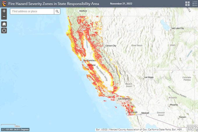
After years of work to develop a sound scientific basis and methodology with a range of experts and stakeholders, updates to this map bring this valuable tool and statutory requirement current in a way that accurately reflects today’s reality for wildfire hazard throughout the state. More specifically, this process includes a few details to know below:
•This current revision only updates areas in California’s unincorporated, rural areaswhere wildfires tend to be frequent—called the “SRA” or “State Responsibility Area.” Thisdoes not include cities or large urban areas.
•This process does not change rules or requirements for homes or properties in these areasrelated to wildfire prevention, preparedness, and mitigation. The same requirements will remainregardless of whether a particular area is reclassified or not.
•The last Wildfire Hazard Severity Zone map was updated in 2007 and required anupdate. A lot has happened since 2007. Using the best available science with academicresearchers and others, this updated map reflects the impacts of a changing climate andincludes a variety of other key factors.
•This is the beginning of a nearly two-month public process. These maps are being shared foryour comments and questions during the regulatory process. A total of 57 public hearings willbe held throughout the state with the goal of hearing from you.
•An online public toolkit and interactive map is available to help answer your questions.Take some time to explore your address, read the FAQs, learn about the process and where toturn. A hotline is also available to help answer your questions directly and to help increaseaccess.
“Ensuring Californians know the wildfire hazard in their area is critical to ensuring we all take the appropriate steps to prepare for wildfires,” said Chief Daniel Berlant, CAL FIRE Deputy Director of Community Wildfire Preparedness and Mitigation. “The updated map is the product of years of discussions and incorporates the latest science to provide a long-term outlook of an area’s wildfire hazard.”
CAL FIRE’s fire scientists and wildfire mitigation experts developed the map using a science-based and field-tested model that assigns a hazard score based on the factors that influence fire likelihood and fire behavior. Many factors are considered, such as fire history, existing and potential fuel (natural vegetation), predicted flame length, blowing embers, terrain, and typical fire weather for an area. These zones fall into the following classifications – moderate, high, and very high.
Working closely with the Department of Insurance and other agencies, CAL FIRE is creating a shared approach to further reduce wildfire risk that assists residents and businesses with accessing affordable insurance. The Department’s first-ever report on climate insurance recommended updated wildfire hazard mapping to improve public safety. Insurance companies and researchers, along with insurance agents and brokers, have been involved throughout this process to ensure cooperation between all sectors to better support Californians. And while insurance companies use similar methodologies to calculate risk as they price their insurance offerings to consumers, insurance risk models also incorporate many factors beyond this process, and many of these factors can change more frequently than those that CAL FIRE includes in its hazard mapping.
CAL FIRE remains committed to answering all questions from the public and working with the Department of Insurance, the insurance industry, and consumer groups throughout this process.
“Making California safer from wildfires is our top priority, and my Department of Insurance will continue to work closely with the first responders at CAL FIRE to better prepare our communities,” said Insurance Commissioner Ricardo Lara, who issued the Safer from Wildfires insurance framework with CAL FIRE and other agencies earlier this year as well as finalizing his new regulation to increase access to wildfire safety discounts and to ensure consumers can learn more about wildfire risks being considered by their insurance company. “Public education about where current wildfire hazards exist is essential to reducing the threat to local communities and maintaining access to affordable insurance. I encourage Californians to ask questions in this public process and to learn more about the tools that exist to help communities and governments reduce their local risks.”
Overall, the map shows increased fire hazard, reflecting California’s increase in wildfire occurrence and severity because of many factors, including a changing climate. The map has been updated to more accurately reflect the zones in California that are susceptible to wildfire, to help provide transparency for planning and preparedness efforts, and to provide communities a forecasting tool so that the public can take steps to prevent and prepare for wildfire. The hazard mapping process incorporates local climate data and changes in burn probability based on recent trends in fire occurrence. The model was reviewed and validated by members of the science community, as well as with outreach with various stakeholders including insurance, building, fire, and local agencies.
“Counties acknowledge the importance of accurately mapping fire hazard severity zones,” said Doug Teeter, Butte County Supervisor and Incoming Chair, Rural County Representatives of California. “RCRC member counties appreciate CAL FIRE’s continued engagement of local governments in this important effort.”
The State Fire Marshal is mandated by California Public Resource Code 4202-4204 to classify lands within the SRA into FHSZs and the most recent SRA FHSZ map was last updated in 2007. The FHSZ zones are used for several purposes, including to designate areas where California’s defensible space standards, wildland-urban interface building codes, and the State Minimum Fire Safe Regulations are required. They can be a factor in real estate disclosure, and local governments may consider them in their general plan.
However, officials stress it is important to note that within the SRA mitigation requirements already apply to all zones. A designation change for an area does not affect the legal requirements for mitigations since they are already required consistently across the SRA. “As we continue to focus on addressing California’s housing crisis, we support the importance of building so that structures are safely designed and built to mitigate an area’s wildfire hazard,” said Dan Dunmoyer, President and CEO of the California Building Industry Association. “To build more fire safe communities in the future, it is critically important for CAL FIRE to update these maps to ensure we all can take steps to build a more resilient California.”
Ways to stay informed and join the conversation As part of the adoption process of the map, CAL FIRE invites public comment on the proposed map between December 16, 2022, and February 3, 2023. The public may submit written comment at the address below or through email at FHSZcomments@fire.ca.gov. In addition, CAL FIRE will host a public comment hearing in all 56 counties that have SRA to receive public comment. Information on the hearings can be found on CAL FIRE’s website at osfm.fire.ca.gov/FHSZ. Written comments may be submitted by U.S. mail to the following address: Office of the State Fire Marshal C/O: FHSZ Comments California Department of Forestry and Fire Protection P.O. Box 944246 Sacramento, CA 94244-2460
To determine the FHSZ of a property, the public can easily search an address using a new FHSZ Viewer at osfm.fire.ca.gov/FHSZ. In order to help California residents better understand the FHSZ map and answer questions, CAL FIRE has created a public toolkit on its website to include new and easy to follow sections, including maps, frequently asked questions, and an automated “hotline” to contact for specific information. The new website also includes dates, times, and locations of FHSZ public hearings that will be held in the 56 Counties that have FHSZs within the SRA.
For information about FHSZs, visit the program’s website at osfm.fire.ca.gov/FHSZ. The public can also call an automated hotline at (916) 633-7655. Following the adoption of the SRA FHSZ Map, CAL FIRE - Office of the State Fire Marshal will begin providing local governments updated FHSZ maps for Local Responsibility Areas. Under California Government Code 51178, the State Fire Marshal is required to provide local agencies with the areas within their jurisdiction that meet FHSZ criteria for their local adoption and implementation.
###
|
| Comments - Make a comment |
| The comments are owned by the poster. We are not responsible for its content. We value free speech but remember this is a public forum and we hope that people would use common sense and decency. If you see an offensive comment please email us at news@thepinetree.net
No Subject
Posted on: 2022-12-16 15:33:01
By: Anonymous
|
|
Such a bunch of Bull *bleep*!! Calfire “The State” know that they can no longer protect the rural communities. Calfire at the direction of the politicians eliminated state resources. Calfire also eliminated the fire resource delivery system. Calfire uses at the direction of the governors office uses ineffective fire resources on fires. Calfire has over the years completely mismanaged the forest, along with the USFS. It is in no way climate change!! Calfire is soft selling a BS story that is going to impact the citizens of California in a very negative manner. Wake up California!!
[Reply
]
|
Re:
Posted on: 2022-12-16 18:50:40
By: Anonymous
|
|
Because of their failures they want to prevent you from using your own land.
[Reply
]
|
Quit coloring maps
Posted on: 2022-12-16 19:57:07
By: Anonymous
|
|
I wish CalFire would quit coloring maps and start cleaning up the brush.
[Reply
]
|
Re: Quit coloring maps
Posted on: 2022-12-16 20:33:01
By: Anonymous
|
|
We need a pay raise
[Reply
]
|
Re: Quit coloring maps
Posted on: 2022-12-16 21:55:31
By: Anonymous
|
|
Will that hunk Gavin be at our local meeting?? Asking for a friend.
Anti
[Reply
]
|
No Subject
Posted on: 2022-12-17 06:44:57
By: Anonymous
|
|
I like the comment . Nothing to do with climate change. Try everything to do with climate change.
[Reply
]
|
Re: everything has to do with climate change
Posted on: 2022-12-17 09:48:53
By: Anonymous
|
|
Not to the deniers.
[Reply
]
|
Re: Quit coloring maps
Posted on: 2022-12-17 07:23:29
By: Anonymous
|
|
Hahahahahahahaha Hohohohohohoho Fuk U 2 sniveler...
[Reply
]
|
No Subject
Posted on: 2022-12-17 09:04:51
By: Anonymous
|
|
Frankly, 99 dollars is a low cost for those one of a kind digital cards. Please sent trump more of your cash now …
[Reply
]
|
Re: Hey Chump
Posted on: 2022-12-17 13:07:19
By: Anonymous
|
|
Trump's NFT cards allow donors to get around campaign reporting requirements so you vicious libs can't do his donors.
Hahaha! Trump outsmarted you again.
[Reply
]
|
Re: Hey Chump
Posted on: 2022-12-17 17:02:00
By: Anonymous
|
|
RAGA ! Rake America Great Again!
Love
Ronald Chump
[Reply
]
|
Re: Hey Chump
Posted on: 2022-12-17 21:38:39
By: Anonymous
|
|
Explain how climate change is the cause.
[Reply
]
|
|
| What's Related |
| These might interest you as well
Local News
Calendar
Photo Albums
phpws Business Directory
|
|
|


