|
Posted by: thepinetree on 02/26/2014 09:27 AM
Updated by: thepinetree on 02/26/2014 09:34 AM
Expires: 01/01/2019 12:00 AM
:

The Storm Door Opens A Bit. Precipitation Heading Our Way Starting Today!
Bear Valley, CA...Today: Cloudy. At lower elevations...a slight chance of rain in the morning...then rain in the afternoon. At higher elevations... A slight chance of rain and snow in the morning...then rain and snow in the afternoon. Highs 39 to 54 higher elevations...50 to 60 lower elevations. Little or no snow accumulation. Snow level 7000 feet. Prevailing south winds up to 15 mph. Gusts up to 30 mph in the afternoon. Over ridges...prevailing south winds 10 to 20 mph increasing to 15 to 30 mph in the afternoon....
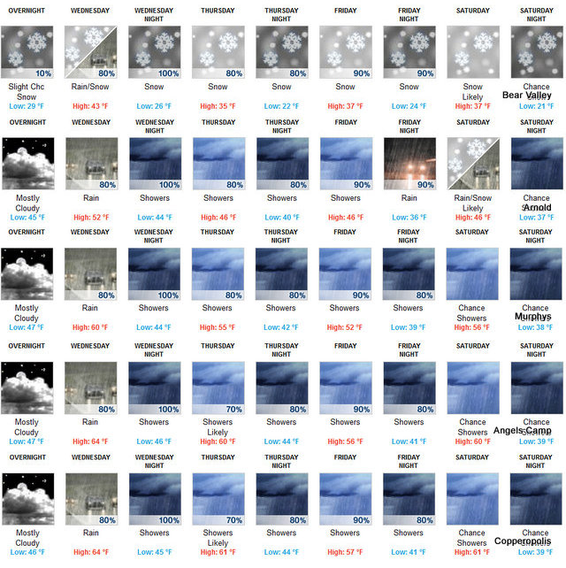
Tonight: At lower elevations...rain in the evening...then rain showers after midnight. At higher elevations...rain and snow in the evening...then rain and snow showers after midnight. Colder. Lows 24 to 39 higher elevations...36 to 44 lower elevations. Snow accumulation 3 to 5 inches higher elevations. Snow level 6500 feet. Prevailing south winds 5 to 15 mph with gusts to around 35 mph. Over ridges...prevailing south winds 20 to 30 mph with gusts to around 45 mph increasing to 30 to 45 mph with gusts to around 60 mph after midnight.
Thursday: Rain showers at lower elevations...and rain and snow showers at higher elevations. Highs 32 to 47 higher elevations... 42 to 54 lower elevations. Snow accumulation of 1 to 4 inches higher elevations. Snow level 6000 feet. Prevailing southwest winds 5 to 15 mph with gusts to around 35 mph. Over ridges... Prevailing southwest winds 25 to 45 mph with gusts to around 65 mph decreasing to 25 to 35 mph with gusts to around 50 mph in the afternoon.
Thursday Night: Partly cloudy with a chance of rain and snow showers in the evening...then mostly cloudy with a chance of rain and snow after midnight. Lows 22 to 37 higher elevations...34 to 44 lower elevations. Snow level 5500 feet. Prevailing southeast winds up to 15 mph. Gusts up to 35 mph in the evening. Over ridges...prevailing southwest winds 25 to 35 mph decreasing to 10 to 20 mph after midnight.
Friday: Rain and snow. Highs 32 to 46 higher elevations...43 to 51 lower elevations. Snow accumulation of 1 to 4 inches higher elevations. Snow level 5500 feet. Prevailing southeast winds up to 15 mph. Over ridges...prevailing south winds 10 to 20 mph with gusts to around 35 mph increasing to 25 to 40 mph in the afternoon.
Friday Night: Rain and snow showers. Moderate snow accumulations possible. Lows 25 to 40.
Saturday: Rain and snow showers likely. Light snow accumulations possible. Highs 36 to 51.
Saturday Night: Mostly cloudy with a chance of rain and snow showers. Lows 23 to 38.
Sunday: Mostly cloudy with a chance of rain and snow showers. Not as cool. Highs 39 to 54.
Sunday Night: Mostly cloudy with a slight chance of rain and snow showers. Lows 23 to 38.
Monday: Mostly cloudy with a chance of rain and snow showers. Highs 40 to 55.
Monday Night: Mostly cloudy with a chance of rain and snow showers. Lows 25 to 40.
Tuesday: Mostly cloudy with a chance of rain and snow showers. Not as cool. Highs 43 to 58.
Winter Weather Advisory
URGENT - WINTER WEATHER MESSAGE
NATIONAL WEATHER SERVICE SACRAMENTO CA
331 AM PST WED FEB 26 2014
CAZ068-069-270000-
/O.CON.KSTO.WW.Y.0006.140227T0000Z-140228T0000Z/
WESTERN PLUMAS COUNTY/LASSEN PARK-
WEST SLOPE NORTHERN SIERRA NEVADA-
331 AM PST WED FEB 26 2014
...WINTER WEATHER ADVISORY REMAINS IN EFFECT FROM 4 PM THIS
AFTERNOON TO 4 PM PST THURSDAY ABOVE 6000 FEET...
* SNOW ACCUMULATIONS: 6 TO 12 INCHES.
* ELEVATION: ABOVE 6000 FEET.
* TIMING: LATE THIS AFTERNOON INTO THURSDAY. HEAVIEST SNOWFALL IS
EXPECTED TONIGHT INTO THURSDAY MORNING.
* LOCATIONS INCLUDE: LASSEN NATIONAL PARK...DONNER PASS...ECHO
SUMMIT...CARSON PASS.
* WINDS: SOUTH 10 TO 20 MPH WITH GUSTS UP TO 35 MPH.
* IMPACTS: TRAVEL DELAYS LIKELY WITH CHAIN CONTROLS THROUGH THE
HIGH NORTHERN SIERRA PASSES.
* CONFIDENCE: HIGH.
* FOR A DETAILED VIEW OF THE HAZARD AREA...VISIT
HTTP://WWW.WEATHER.GOV/SACRAMENTO/HAZARDS.
PRECAUTIONARY/PREPAREDNESS ACTIONS...
A WINTER WEATHER ADVISORY MEANS THAT PERIODS OF SNOW WILL CAUSE
TRAVEL DIFFICULTIES. BE PREPARED FOR SLIPPERY ROADS AND LIMITED
VISIBILITIES...AND USE CAUTION WHILE DRIVING.
&&
INTERACT WITH US VIA SOCIAL MEDIA
WWW.FACEBOOK.COM/NWS.SACRAMENTO
WWW.TWITTER.COM/NWSSACRAMENTO
$$
|
| Comments - Make a comment |
| The comments are owned by the poster. We are not responsible for its content. We value free speech but remember this is a public forum and we hope that people would use common sense and decency. If you see an offensive comment please email us at news@thepinetree.net
|
| What's Related |
| These might interest you as well
Local News
Photo Albums
phpws Business Directory
Calendar
Link Manager
Web Pages
|
|
|


