Posted by: Staff_Writer on 09/21/2013 09:14 AM
Updated by: Staff_Writer on 09/21/2013 09:22 AM
Expires: 01/01/2018 12:00 AM
:

Snow Levels 7,900 Feet Today...Clear By Tomorrow with Highs in the 70's At Lower Elevations
Bear Valley, CA...We have our first white flakes of the season on the forecast and lets hope this light system will take the rest of the heat out of the Rim Fire. For Today...Rain showers before 5pm, then rain, possibly mixed with snow showers. Temperature rising to near 50 by 11am, then falling to around 43 during the remainder of the day. Breezy, with a southwest wind 18 to 22 mph, with gusts as high as 33 mph. Chance of precipitation is 80%. Little or no snow accumulation expected. Tonight Rain and snow showers likely, becoming all rain showers after 8pm, then gradually ending. Snow level 7900 feet. Mostly cloudy, with a low around 29. Southwest wind 7 to 16 mph, with gusts as high as 24 mph. Chance of precipitation is 70%. Little or no snow accumulation expected...
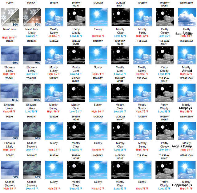
Sunday Mostly sunny, with a high near 59. Calm wind becoming west 5 to 7 mph in the afternoon.
Sunday Night Partly cloudy, with a low around 40. West wind 5 to 10 mph becoming light and variable in the evening.
Monday Sunny, with a high near 66. Light and variable wind becoming southwest 8 to 13 mph in the afternoon. Winds could gust as high as 20 mph.
Monday Night Mostly clear, with a low around 42.
Tuesday Mostly sunny, with a high near 62.
Tuesday Night Partly cloudy, with a low around 35.
Wednesday Partly sunny, with a high near 50.
Wednesday Night Partly cloudy, with a low around 31.
Thursday Mostly sunny, with a high near 54.
Thursday Night Mostly clear, with a low around 34.
Friday Sunny, with a high near 61.
|


