|
Posted by: thepinetree on 08/28/2013 08:13 AM
Updated by: John_Hamilton on 08/28/2013 12:13 PM
Expires: 01/01/2018 12:00 AM
:

Rim Fire Morning Update...187,466 Acres, 23% Contained, 4,191 Personnel, Cost 33 Million
Groveland, CA...Last night, firefighters conducted a burning operation from Paper Cabin Ridge down to the Tuolumne River and south from Duckwall Mountain to Skidmore. Crews secured fireline around spot fires in Reynolds Creek and dozers worked on constructing fireline north from Duckwall Mountain towards Fahey Meadow. In the southern part of the fire, crews secured the line near Pilot Ridge and near the border of Yosemite National Park. For today if conditions allow, crews are expected to begin a large burning operation from Hetch Hetchy Reservoir south to Tioga Road in Yosemite National Park in an effort to stop the spread of the fire to the east, as well as a burning operation from Highway 120 to Pilot Peak...
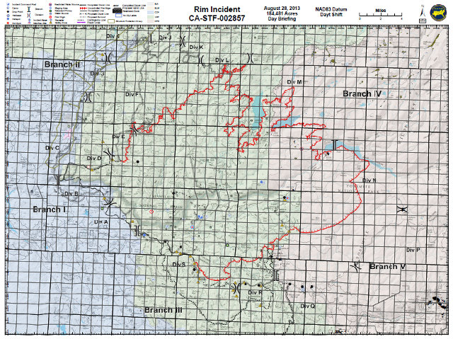
The Detailed Incident Briefing Map for Today's Rim Fire Fight
Update #18
Release for Wednesday, August 28, 2013/Time: 6:00 AM
Incident Statics
Acres Burned: 187,466 Structures Threatened: 4,500
Containment: 23% Structures Destroyed: 111
Fire Start Date: August 17, 2013 Injuries: 3
Fire Cause: Under Investigation Total Personnel: 4,191
Cost to date: $33 Million
Fire Update
Last night, firefighters conducted a burning operation from Paper Cabin Ridge down to the Tuolumne River and south from Duckwall Mountain to Skidmore. Crews secured fireline around spot fires in Reynolds Creek and dozers worked on constructing fireline north from Duckwall Mountain towards Fahey Meadow. In the southern part of the fire, crews secured the line near Pilot Ridge and near the border of Yosemite National Park. For today if conditions allow, crews are expected to begin a large burning operation from Hetch Hetchy Reservoir south to Tioga Road in Yosemite National Park in an effort to stop the spread of the fire to the east, as well as a burning operation from Highway 120 to Pilot Peak.
Park and Forest Closures
Yosemite National Park has closed Tamarack Flat and Yosemite Creek Campgrounds, both located along the Tioga Road. White Wolf Campground and White Wolf Lodge will remain closed. If you have questions about Yosemite National Park please call 209-372-0327 or 209-372-0329. The Stanislaus National Forest has issued an area closure for the entire Groveland Ranger District and for the Mi-Wok Ranger District east of Highway 108. Additional details are available from the Groveland Ranger District, 209-962-7825
Road Closures
Highway 120 remains closed to all inbound and outbound Yosemite National Park traffic to Crane Flat Campground. A portion of the Tioga Road, from Crane Flat to White Wolf, will be temporarily closed to all vehicular traffic beginning tomorrow, Wednesday, August 28, 2013, at 12:00 noon. Highway 120 east/Tioga Road remains open from White Wolf east to the Tioga Pass entrance. Also closed are Graham Ranch Road, Cherry Lake at Highway 120, Evergreen Road and Old Yosemite Road. Highway 120 from Ferretti Road to Buck Meadows remains open only for local residents and business only.
Evacuations and Advisories
A Mandatory Evacuation has been issued for residences north of Old Yosemite Road (Forest Road 2S01). Highway 120 at the Yosemite National Park boundary west to Buck Meadows has been evacuated. An evacuation center is located at the Mother Lode Fairgrounds in Sonora. An evacuation advisory is in effect from Tuolumne City and the area east of Highway 108 to Pinecrest Lake. An Evacuation Warning has been issued for all residences north of Bull Creek Road (Forest Road 2S02), Bondurant Mine Road, Texas Hill Road, and Wampum Hill.
For more information on this press release or if you have questions regarding the information, please contact the Rim Fire at 805-727-4775 or 805-727-4746. Updated information can also be obtained at http://www.inciweb.org/incident/3660/. All media is requested to report to the Incident Command Post to check in with the Public Information Officers.
|
| Comments - Make a comment |
| The comments are owned by the poster. We are not responsible for its content. We value free speech but remember this is a public forum and we hope that people would use common sense and decency. If you see an offensive comment please email us at news@thepinetree.net
|
| What's Related |
| These might interest you as well
Local News
Calendar
phpws Business Directory
Photo Albums
|
|
|


