|
Posted by: thepinetree on 08/27/2013 03:40 PM
Updated by: thepinetree on 08/27/2013 04:13 PM
Expires: 01/01/2018 12:00 AM
:

Rim Fire Afternoon Update...$27,229,744, 179,481 Acres, 31 Residences 80 Outbuildings Lost
Tuolumne, CA...Firefighters worked overnight on yesterday’s spot fires and continued with line construction throughout the fire. Crews were successful in getting a dozer line around spot fires at Duckwall Mountain. Firefighters were able to get line in, and successfully burn out the adjacent to Yosemite National Park south of Highway 120 to slow the spread of the fire. Today, fire crews will continue working the spot fires and structure defense north and south of Highway 120 from pilot Ridge to Yosemite National Park. Fire fighters will also continue with contingency line construction in advance of the communities in the Highway 108 corridor...
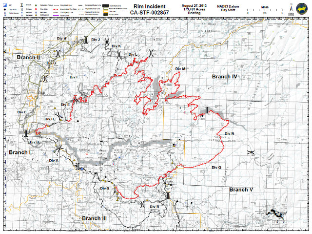
For those following the rim fire in detail this map is a treasure trove and is the second day we have been able to provide copies of the incident briefing maps.
Fire Update as of August 27, 2013
Firefighters worked overnight on yesterday’s spot fires and continued with line construction throughout the fire. Crews were successful in getting a dozer line around spot fires at Duckwall Mountain. Firefighters were able to get line in, and successfully burn out the adjacent to Yosemite National Park south of Highway 120 to slow the spread of the fire. Today, fire crews will continue working the spot fires and structure defense north and south of Highway 120 from pilot Ridge to Yosemite National Park. Fire fighters will also continue with contingency line construction in advance of the communities in the Highway 108 corridor.
Basic Information
Incident Type Wildfire
Cause Under Investigation
Date of Origin Saturday August 17th, 2013 approx. 03:15 PM
Location Groveland Range District, Stanislaus NF
Incident Commander Wilkins/lawshe
Current Situation
Total Personnel 3,752
Size 179,481 acres
Percent Contained 20%
Fuels Involved
Brush, Oaks, and Pine
Fire Behavior
Fire activity remained fairly active overnight with active surface fire and torching and spotting.
Significant Events
Mandatory evacuations south of Highway 120 and north of Old Yosemite Road. Structure defense is in place for this area of the fire by ground and aerial resources. An evacuation advisory has been extended on the Highway 108 corridor from Tuolumne City to Pinecrest. A Forest Closure is in effect for locations near and in advance of the fire. Several locations on the west side of Yosemite National Park have had closures implemented as a result of the fires spread. Contingency planning, indirect line construction and preparation to the east of Highway 108. Access and difficult terrain remain concerns for crews and equipment. Good progress was made with constructing and securing lines along the southwestern edge of the fire. Good progress is being achieved with construction of contingency control lines along the northeastern edge of the fire.
Outlook
Planned Actions
Continued line construction where accessibility and safety allows.
Growth Potential
Extreme
Terrain Difficulty
Extreme
Remarks
Damage assessments from the Berkeley Tuolumne Camp revealed extensive losses of infrastructure. Rapid fire growth and extreme fire behavior are hampering suppression efforts. A significant utilization and reliance upon aerial resources with heavy air tankers including DC-10s and MAFFS (C-130's) is occurring with structure defense prep of locations in advance of the fires spread, control of spot fires and slowing the fires advancement through terrain inaccessible to ground resources.
Current Weather
Wind Conditions 15 mph SW
Temperature 89 degrees
Humidity 21%
|
| Comments - Make a comment |
| The comments are owned by the poster. We are not responsible for its content. We value free speech but remember this is a public forum and we hope that people would use common sense and decency. If you see an offensive comment please email us at news@thepinetree.net
|
| What's Related |
| These might interest you as well
Local News
Calendar
phpws Business Directory
Photo Albums
|
|
|


