| Coming Soon... |
| Sunday, May 5 |
| All Day | Our Sunday Edition with Local Features, Local Specials & More Every Sunday All Day Long! |
| Sunday, May 12 |
| All Day | Our Sunday Edition with Local Features, Local Specials & More Every Sunday All Day Long! |
| Thursday, May 16 |
| All Day | Calaveras County Fair & Jumping Frog Jubilee Gold Pans and Cattle Brands May 16-19, 2024 |
| All Day | California Gold Rush History Comes to Life at Columbia State Historic Park |
| Friday, May 17 |
| All Day | Calaveras County Fair & Jumping Frog Jubilee Gold Pans and Cattle Brands May 16-19, 2024 |
| All Day | California Gold Rush History Comes to Life at Columbia State Historic Park |
| Saturday, May 18 |
| All Day | Calaveras County Fair & Jumping Frog Jubilee Gold Pans and Cattle Brands May 16-19, 2024 |
| All Day | California Gold Rush History Comes to Life at Columbia State Historic Park |
| 07:00 AM | Steps Against Melanoma Fundraising Walk |
|
|
Posted by: thepinetree on 08/09/2012 10:32 AM
Updated by: thepinetree on 08/09/2012 11:56 AM
Expires: 01/01/2017 12:00 AM
:

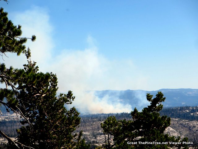
225 Acre Wheats Fire Starting to Close Trails Near Spicer Reservoir
Bear Valley, CA..Current Situation: The fire is consuming red fir within the Carson-Iceberg Wilderness of the Stanislaus National Forest sending up occasional plumes of smoke. Advance of the fire is impeded by dispersed granite rock formations and light winds. Plans include switching out fire crews and establishing indirect fire lines. A fire camp has been established at the Spicer Reservoir Group Campground with a boat ride and a 20 minute hike to access the northern perimeter of the fire. The Forest has closed several trails in the area (see attached map for details). Because legislation restricts the use of mechanical devices in wilderness areas special authority has been granted to use chainsaws and water pumps. The very steep and rugged isolated terrain is a cause of concern for firefighter safety. A Type 3 Incident Commander is in-charge of the response. About 225 acres have burned. Possible thunder storm clouds could develop over the next few days.....
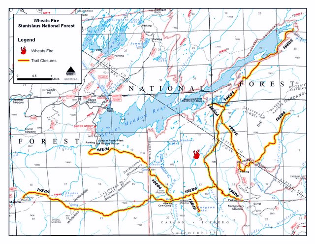
Additional Details and Larger Map is Enclosed...
Basic Information
Incident Type Wildfire
Cause Lightning
Date of Origin Monday August 06th, 2012 approx. 08:00 AM
Location Summit and Calaveras Ranger Districts
Current Situation
Total Personnel 60
Size 130 acres
Percent Contained 20%
Estimated Containment Date Saturday August 11th, 2012 approx. 12:00 AM
Outlook
Terrain Difficulty
The very steep and rugged isolated terrain is a cause of concern for firefighter safety.
Remarks
Smoke has been reported from Highway 108 in Tuolumne County and may be seen from Highway 4 in Calaveras County.
|
| Comments - Make a comment |
| The comments are owned by the poster. We are not responsible for its content. We value free speech but remember this is a public forum and we hope that people would use common sense and decency. If you see an offensive comment please email us at news@thepinetree.net
|
| What's Related |
| These might interest you as well
Local News
- Big Trees Market Weekly Ad, Grocery, Produce, Meat & Deli Specials Thr...
- Big Trees Market Weekly Ad, Grocery, Produce, Meat & Deli Specials Thr...
- Don't Miss the High Sierra Bike-a-Palooza on May 4th!
- The Arnold Summer Pancake Breakfasts Return for Memorial Day, July 4th...
- The 2024 Arnold Firewise Community Meeting is May 4th!
- Traffic Update...Vehicle vs Motorcycle Near Post Office on Blagen Road
- James Nicholson 1930 ~ 2024
- Mornings with the One Percent™ This Morning's Replay is Below!
- The Trout Spot Is Your Destination For All Things Fly & Trout Fishing,...
- Chapel in the Pines Sunday Service, April 28, 2024
phpws Business Directory
Photo Albums
Calendar
Link Manager
Web Pages
|
|
|


