|
Posted by: John_Hamilton on 12/01/2011 05:17 AM
Updated by: John_Hamilton on 12/01/2011 05:36 AM
Expires: 01/01/2016 12:00 AM
:
Blustery Weather Forecast...Wind Gusts Up to 100mph
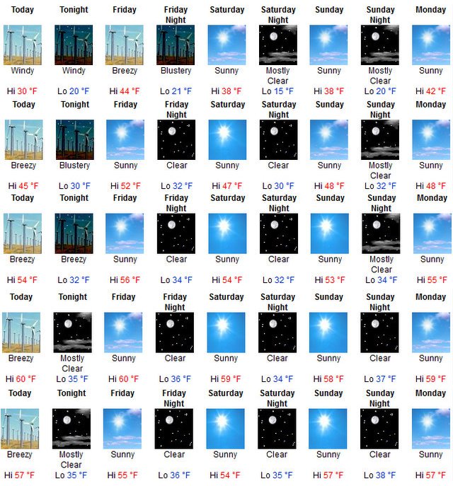
Arnold, CA...Today: Sunny, with a high near 45. Breezy, with a northeast wind 23 to 26 mph decreasing to between 15 and 18 mph. Winds could gust as high as 40 mph. Tonight: Mostly clear, with a low around 30. Blustery, with a east northeast wind around 26 mph, with gusts as high as 40 mph...

The graphic above starts in Bear Valley and includes Arnold, Murphys, Angels Camp & Copperopolis
Friday: Sunny, with a high near 52. Northeast wind 13 to 16 mph decreasing to between 5 and 8 mph. Winds could gust as high as 24 mph.
Friday Night: Clear, with a low around 32. Northeast wind between 5 and 10 mph.
Saturday: Sunny, with a high near 47. East wind between 6 and 13 mph.
Saturday Night: Clear, with a low around 30.
Sunday: Sunny, with a high near 48.
Sunday Night: Mostly clear, with a low around 32.
Monday: Sunny, with a high near 48.
Monday Night: Partly cloudy, with a low around 33.
Tuesday: Sunny, with a high near 50.
Tuesday Night: Mostly clear, with a low around 33.
Wednesday: Sunny, with a high near 50.
High Wind Warning
URGENT - WEATHER MESSAGE
NATIONAL WEATHER SERVICE SACRAMENTO CA
246 AM PST THU DEC 1 2011
CAZ068-069-020200-
/O.CON.KSTO.HW.W.0003.000000T0000Z-111202T1400Z/
WESTERN PLUMAS COUNTY/LASSEN PARK-
WEST SLOPE NORTHERN SIERRA NEVADA-
INCLUDING THE CITIES OF...CHESTER...QUINCY
246 AM PST THU DEC 1 2011
...HIGH WIND WARNING REMAINS IN EFFECT UNTIL 6 AM PST FRIDAY...
A HIGH WIND WARNING REMAINS IN EFFECT UNTIL 6 AM PST FRIDAY.
* TIMING...BECOMING VERY WINDY EARLY THIS MORNING AND CONTINUING
OVERNIGHT.
* WIND SPEEDS ABOVE 4500 FEET...AREAS OF NORTHEAST WINDS 35 TO
50 MPH WITH GUSTS TO 80 MPH OVER EXPOSED AREAS AND THROUGH
AND BELOW FAVORED PASSES AND CANYONS...GUSTS UP TO 100 MPH
OVER HIGHEST RIDGES.
* BETWEEN 3000 AND 4500 FEET...AREAS OF NORTHEAST WINDS 25 TO
45 MPH WITH GUSTS AROUND 60 MPH OVER EXPOSED AREAS AND
THROUGH AND BELOW FAVORED PASSES AND CANYONS.
* IMPACTS...DOWNED TREES AND POWER LINES WILL BE POSSIBLE.
TRAVEL WILL BE VERY HAZARDOUS OVER THE SIERRA PASSES...
ESPECIALLY TO HIGHER PROFILE VEHICLES.
PRECAUTIONARY/PREPAREDNESS ACTIONS...
A HIGH WIND WARNING MEANS A HAZARDOUS HIGH WIND EVENT IS EXPECTED
OR OCCURRING. SUSTAINED WIND SPEEDS OF AT LEAST 40 MPH OR GUSTS
OF 58 MPH OR MORE CAN LEAD TO PROPERTY DAMAGE.
&&
$$
Hazardous Weather Outlook
HAZARDOUS WEATHER OUTLOOK
NATIONAL WEATHER SERVICE SACRAMENTO CA
700 AM PST WED NOV 30 2011
CAZ013>019-063-064-066>069-011500-
SHASTA LAKE AREA/NORTHERN SHASTA COUNTY-
BURNEY BASIN/EASTERN SHASTA COUNTY-NORTHERN SACRAMENTO VALLEY-
CENTRAL SACRAMENTO VALLEY-SOUTHERN SACRAMENTO VALLEY-
CARQUINEZ STRAIT AND DELTA-NORTHERN SAN JOAQUIN VALLEY-
MOUNTAINS SOUTHWESTERN SHASTA TO NORTHERN LAKE COUNTIES-
CLEAR LAKE/SOUTHERN LAKE COUNTY-MOTHERLODE-
EAST FOOTHILLS/NORTH SACRAMENTO VALLEY-
WESTERN PLUMAS COUNTY/LASSEN PARK-WEST SLOPE NORTHERN SIERRA NEVADA-
700 AM PST WED NOV 30 2011
THIS HAZARDOUS WEATHER OUTLOOK IS FOR INTERIOR NORTHERN CALIFORNIA.
.DAY ONE...TODAY
IT WILL BECOME WINDY TODAY IN THE VALLEY AND FOOTHILLS...DECREASING
TONIGHT OVER THE EASTERN SIDE OF THE VALLEY AND BECOMING WINDY AGAIN
THURSDAY. NORTHERLY WINDS 20 TO 40 WITH GUSTS TO AROUND 50 MPH ARE
EXPECTED. WINDS IN THE MOUNTAINS WILL INCREASE THIS AFTERNOON
BECOMING VERY WINDY TONIGHT THROUGH THURSDAY NIGHT.
NORTHEAST WINDS INCREASING TO 35 TO 50 MPH WITH GUSTS TO 80 MPH.
GUSTS UP TO 100 MPH ARE POSSIBLE OVER HIGHEST RIDGES. NORTHEAST
WINDS 25 TO 45 MPH WITH GUSTS TO 60 MPH AT ELEVATIONS BETWEEN 3000
AND 5000 FEET.
* HIGH WIND WARNING..........SEE WWUS76 KSTO - NPWSTO FOR DETAILS *
* WIND ADVISORY..............SEE WWUS76 KSTO - NPWSTO FOR DETAILS *
.DAYS TWO THROUGH SEVEN... THURSDAY THROUGH TUESDAY
SEE ABOVE TEXT FOR DAY ONE.
* HIGH WIND WARNING..........SEE WWUS76 KSTO - NPWSTO FOR DETAILS *
* WIND ADVISORY..............SEE WWUS76 KSTO - NPWSTO FOR DETAILS *
.SPOTTER INFORMATION STATEMENT...
WEATHER SPOTTERS ARE ENCOURAGED TO REPORT SIGNIFICANT WEATHER
CONDITIONS TO THEIR LOCAL NATIONAL WEATHER SERVICE OFFICE.
THE LATEST WEATHER INFORMATION IS AVAILABLE ON THE INTERNET AT
(LOWER CASE): HTTP://WWW.WRH.NOAA.GOV/STO
$$
|
| Comments - Make a comment |
| The comments are owned by the poster. We are not responsible for its content. We value free speech but remember this is a public forum and we hope that people would use common sense and decency. If you see an offensive comment please email us at news@thepinetree.net
|
| What's Related |
| These might interest you as well
Local News
Photo Albums
phpws Business Directory
Calendar
Link Manager
Web Pages
|
|
|


