Posted by: Kim_Hamilton on 01/08/2011 11:29 AM
Updated by: Kim_Hamilton on 01/08/2011 11:29 AM
Expires: 01/01/2016 12:00 AM
:
Tuolumne River Plan.....Coming Early 2011... Draft Environmental Impact Statement
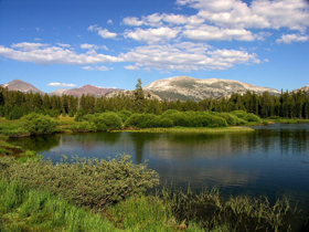
Yosemite National Park, CA.....As seen from Tuolumne Meadows (8,600 feet in elevation), the Tuolumne appears to be a peaceful sleeper of a river, meandering quietly through its meadow channel or sweeping in riffles over the granite river bottom. It originates from two mighty forks deep in Yosemite's wilderness--the Dana and the Lyell.....

These forks meet in Tuolumne Meadows for the river's last gentle pass before plunging and waterwheeling over a series of stair-step cascades to Glen Aulin and on to the Grand Canyon of the Tuolumne River and the Muir Gorge. From lush Pate Valley, the Tuolumne continues for trailless miles to before it tumbles into Hetch Hetchy Reservoir. Beyond O'Shaughnessy Dam, it continues its journey, cascading and meandering through Poopenaut Valley before it leaves the park boundary and continues through the Sierra foothills to the Central Valley. The entire Tuolumne River corridor is rich in natural, cultural, and scenic wonders, as well as opportunities for recreation.
Because of its free-flowing condition and "outstandingly remarkable values," in 1984, Congress added 83 miles of the Tuolumne River to the Wild and Scenic Rivers System, 54 miles of which flow through Yosemite National Park. In accordance with the Wild and Scenic Rivers Act, the NPS must prepare a comprehensive management plan to establish the long-term guidance for protecting water quality, free-flowing condition, and unique values for the portion of the Tuolumne River that flows through the park. The process to create the Tuolumne Wild and Scenic River Comprehensive Management Plan and its accompanying environmental impact statement (Tuolumne River Plan/EIS) began in 2006, and a draft document for public review is anticipated for release in early 2011. If approved, the plan will become finalized by the end of 2011.
|


