The Latest Forecast Update....Snow Level Starts To Drop Tonight
Posted by: thepinetree on 01/08/2017 02:04 PM
Arnold, CA...The latest from West Slope Northern Sierra Nevada Rest Of Today Heavy rain and isolated thunderstorms. Windy. Not as cool. Highs 37 to 49 higher elevations...46 to 54 lower elevations. Prevailing south winds 20 to 35 mph with gusts to around 60 mph...except south 35 to 50 mph with gusts to around 65 mph over ridges. Tonight At lower elevations, heavy rain showers. At higher elevations, heavy rain showers in the evening, then heavy rain showers and heavy snow showers after midnight. Windy, colder. Lows 25 to 39 higher elevations...36 to 44 lower elevations. No snow accumulation lower elevations...4 to 10 inches higher elevations. Snow level 7500 feet after midnight. Prevailing southwest winds 15 to 30 mph with gusts to around 50 mph...except southwest 25 to 45 mph over ridges.
Sacramento, CA....The National Weather Service has updated their flood watch warning to run through Wednesday afternoon. Please use caution on our area roadways and make plans if you live in a low lying area. Full text of the updated warnings updated this morning area below...
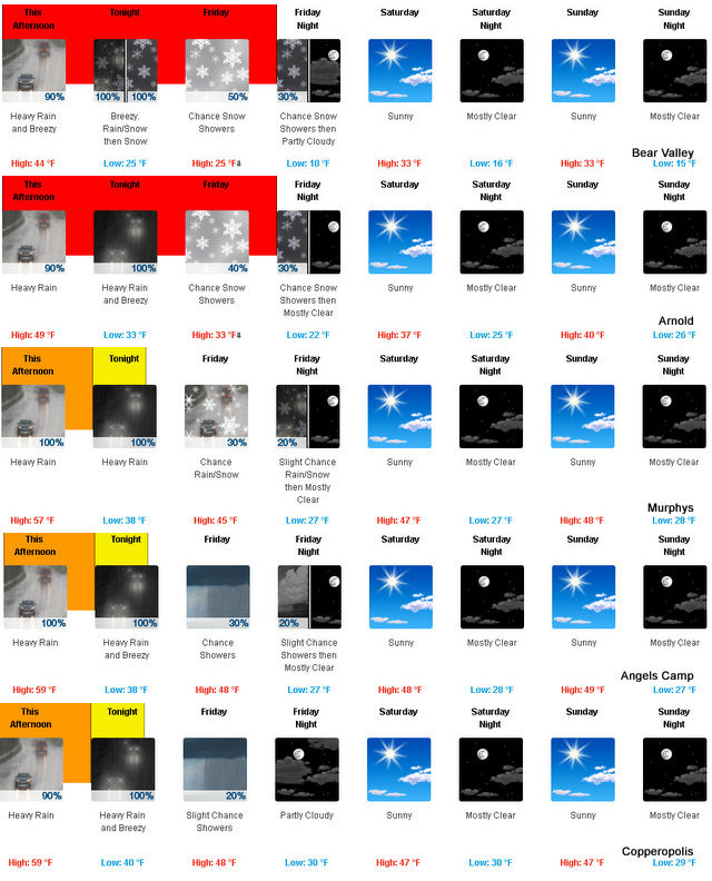
Batten Down Your Hatches Calaveras! ~ Storm Predicted Saturday Through Monday
Posted by: News_Desk on 01/06/2017 02:53 PM
Calaveras County, CA...National Weather Service Forecasts Storm for Saturday with Heavy Precipitation Sunday Through Monday Morning. Possibility of Debris Flows Over Burn Scars. Stay Alert During Emergencies.
The Latest Forecast, Advisories & Storm Warnings For West Slope Northern Sierra Nevada.
Posted by: thepinetree on 01/06/2017 10:20 PM
Arnold, CA...Rest Of Tonight Mostly cloudy. Scattered rain and snow showers after midnight. Lows 19 to 34 higher elevations...30 to 40 lower elevations. Little or no new snow accumulation lower elevations... Except new snow accumulation up to 1 inch higher elevations. Snow level 3500 feet after midnight. Prevailing southeast winds up to 15 mph. Gusts up to 35 mph after midnight. Saturday At lower elevations, widespread heavy rain showers and heavy snow showers in the morning, then heavy rain in the afternoon. At higher elevations, widespread snow showers and heavy rain showers in the morning, then heavy rain and snow in the afternoon. Breezy. Not as cool. Highs 33 to 47 higher elevations...43 to 51 lower elevations. No snow accumulation lower elevations...4 to 9 inches higher elevations. Snow level 6000 feet increasing to 7000 feet in the afternoon. Prevailing south winds 15 to 25 mph with gusts to around 45 mph...except south 25 to 45 mph over ridges.
Calaveras County Sand Bag Locations Stocked In Preparation For Upcoming Storms (County Bringing More Sand & Sandbags To Westpoint)
Posted by: News_Desk on 01/05/2017 02:35 PM
Calaveras County, CA...(Update...The county has brought sand and bags to the West Point Volunteer Fire Station) All Sand Bag Stations are stocked and open in preparation of the upcoming storm systems. The weather service is calling for Significant Rain and Flooding this Weekend-Early Next Week. Moderate precipitation starts Saturday (7th), but the brunt of storm will be Sunday and Monday. Some localized minor flooding has occurred however; Road crews are out working to keep Calaveras County roads open and clear. Hawver Ranch Road is still closed from Victory to Jesus Maria Rd. Plan Ahead, be prepared! For Safety Tips go to: http://bit.ly/2hTOBSw
Weather Outlook For Calaveras County ~ Severe Weekend Conditions
Posted by: News_Desk on 01/05/2017 05:56 PM
Calaveras County, CA...Widespread Weather for Northern California is forecasted for the January 7, 2017 through January 10, 2017. The National Weather Service is predicting that Calaveras County will likely be impacted by this storm. The following information is from the National Weather Service:
Sand Bags Available To Angels Camp Residents For Severe Weekend Weather
Posted by: News_Desk on 01/05/2017 01:28 PM
Angels Camp, CA...With a possibility of severe weather and flooding this weekend, City of Angels residents are welcome to fill sand bags for free behind the Police Department located at 200 Monte Verda Street.
Sandbags & Sand Available At Copperopolis Fire Station ~ Open 24 Hours
Posted by: News_Desk on 01/05/2017 01:18 PM
Copperopolis, CA...With the expectation of extreme weather conditions through the weekend, there is a strong possibility of flooding. Your Copperopolis Fire Protection District has set up a self-service sandbag area behind the Fire Station next to the storage containers. There you will find sand, shovels and sandbags.
2017 Starts Off With A Busy And Wintery Weather Week
Posted by: thepinetree on 01/02/2017 04:13 PM
Bear Valley, CA...The National Weather Service is projecting a busy weather week along the West Slope Northern Sierra Nevada Tonight Snow showers. Lows 13 to 28 higher elevations...26 to 34 lower elevations. Snow accumulation of 3 to 6 inches. Prevailing south winds 5 to 15 mph with gusts to around 35 mph... Except south 20 to 35 mph over ridges. Tuesday Snow showers. Not as cold. Highs 23 to 37 higher elevations...34 to 42 lower elevations. Snow accumulation of 1 to 6 inches lower elevations...except 3 to 5 inches higher elevations. Prevailing southeast winds 5 to 15 mph with gusts to around 30 mph...except south 15 to 30 mph over ridges.
Our Weather Page always has the latest road conditions and weather forecasts!
This Storm Wave Bringing Heavy Rain & Up To 15 Inches Of Snow At Higher Elevations
Posted by: thepinetree on 12/15/2016 02:34 PM
Bear Valley, CA...West Slope Northern Sierra Nevada. Today At lower elevations, rain likely in the morning, then heavy rain in the afternoon. At higher elevations, rain and snow likely in the morning, then heavy rain and heavy snow in the afternoon. Windy. Highs 36 to 50 higher elevations...46 to 54 lower elevations. No snow accumulation lower elevations...2 to 4 inches higher elevations. Snow level above 8000 feet. Prevailing south winds 15 to 30 mph with gusts to around 50 mph... Except southwest 25 to 45 mph with gusts to around 60 mph over ridges.