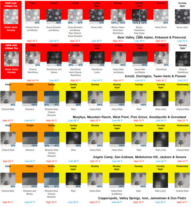
Winter Storm Warning with Snow Down to 1,000 Feet Through Saturday
Posted by: thepinetree on 02/21/2023 08:43 AM
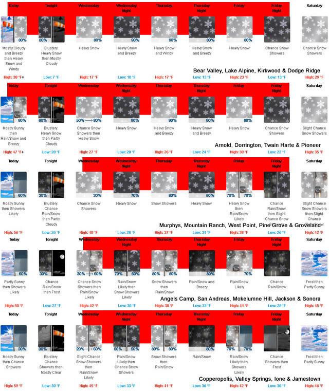
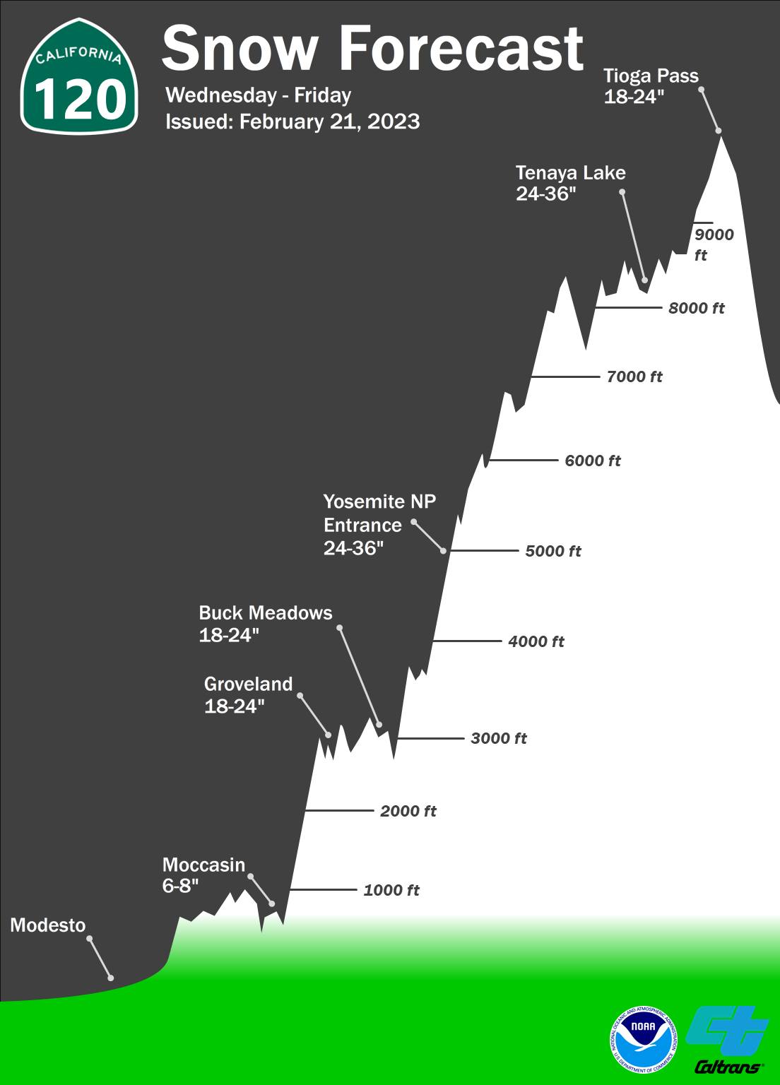
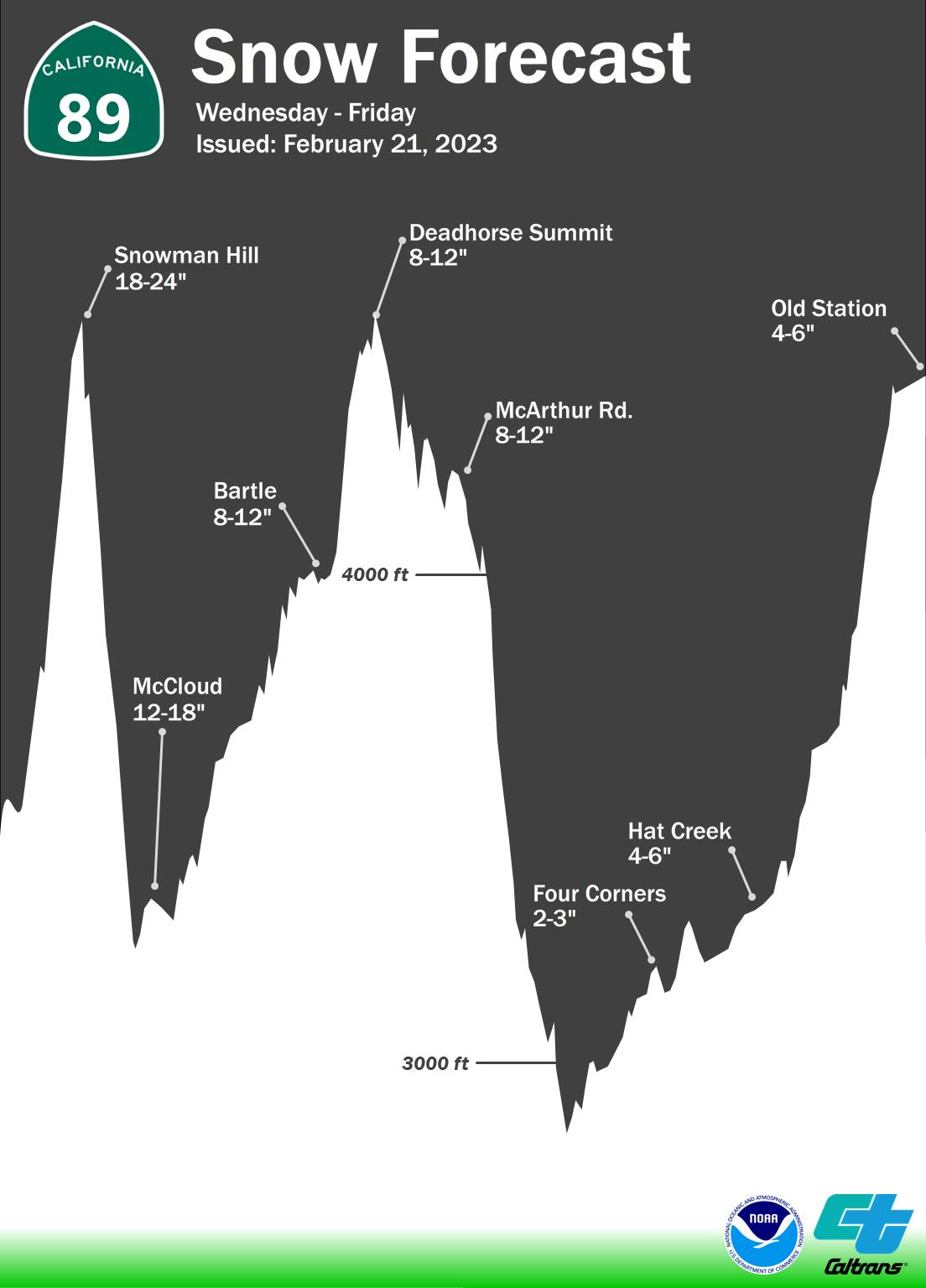
Arnold, CA...So you thought that Mother Nature was done with us for this winter? Well, Well...think again. This batch of systems are forecasted to bring snow down to the lowest elevations of the year. Heavy snow expected. Total snow accumulations of 1 to 3 feet, with locally higher amounts. Winds gusting as high as 70 mph.
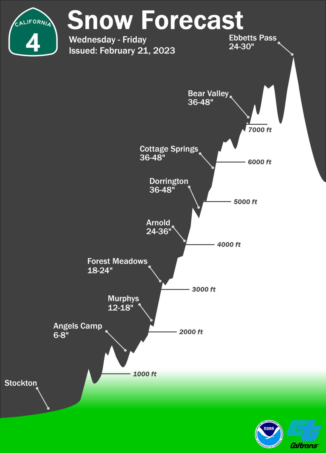
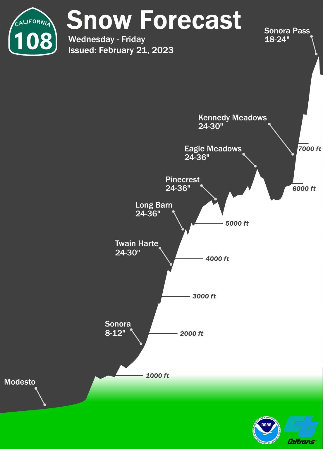
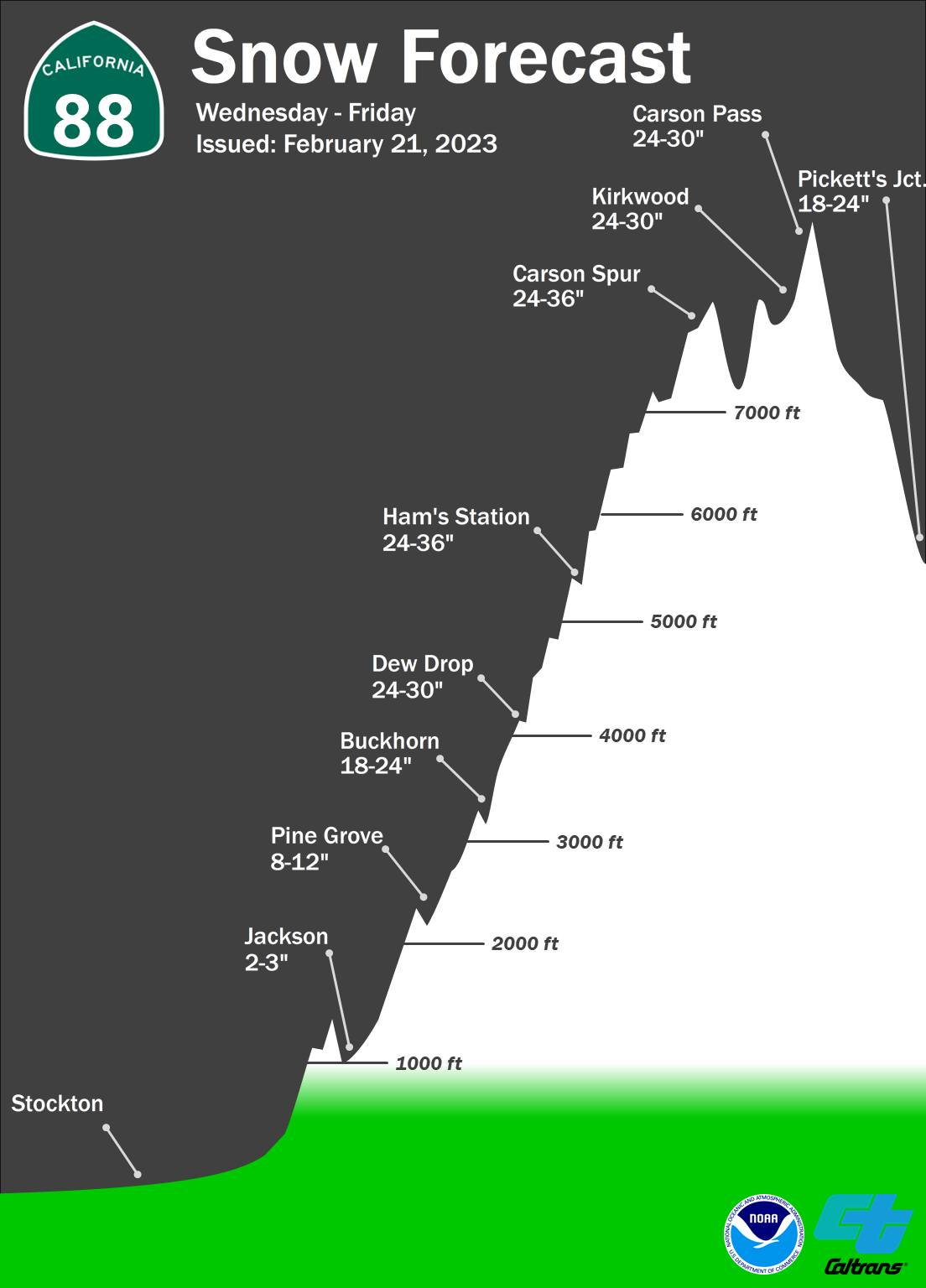
Arnold, CA...To help you plan ahead and be prepared, the National Weather Service has provided these snow cross sections for highways and interstates in District 10, effective Wednesday afternoon through Friday morning.
Beautiful, Crisp President's Weekend Ahead! Time to Go Out & Play!
Posted by: thepinetree on 02/16/2023 12:14 PM
Arnold, CA...A Beautiful President's Weekend is ahead. Go out & play! The West Slope & Mother Lode forecasts are below. Detailed NWS forecast for West Slope Northern Sierra Nevada. Tonight, Mostly cloudy. Lows 12 to 27 higher elevations...26 to 36 lower elevations. Prevailing southeast winds up to 10 mph. Friday, Mostly cloudy in the morning then clearing. Not as cool. Highs 33 to 48 higher elevations...47 to 57 lower elevations. Prevailing east winds up to 10 mph shifting to the north in the afternoon.
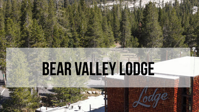
Bear Valley, CA... What To Expect On 2/5/23 at Bear Valley Ski Resort. MORE POW IS ON THE WAY!!! Last Night – Things kick into high gear as 17-23″ looks to fall overnight but the bigger element is high winds increasing into the mid 30’s on average with 50mph+ gusts and even sustained for a bit after the midnight hour. Sunday 2/5 – Another 10-14″ looks to fall during the day Sunday with winds decreasing slightly but still into the mid 30’s or so. The system looks to exit east overnight Sunday making way for another day on Monday for quality POW riding.
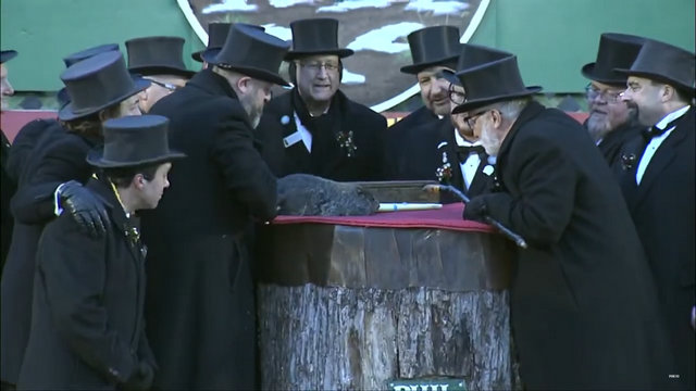
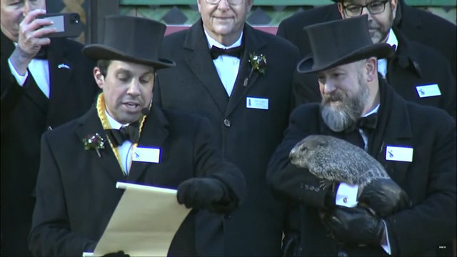
San Andreas, CA....Shortly after Punxsutawney Phil predicted another six weeks of winter this morning the CCSO said they wanted to bring the rodent in for questioning.
Winter Returns with Storm Watch & Up To 28 Inches of Snow Above 6,000 Ft.
Posted by: thepinetree on 02/02/2023 02:49 PM
Arnold, CA...NWS Sacramento has issued a Winter Storm Watch from Saturday afternoon through Sunday evening.. Heavy snow possible. Total snow accumulations of 6 to 15 inches above 4000 feet with 15 to 28 inches above 6000 feet. Winds could gust as high as 55 mph. The Detailed forecast for West Slope Northern Sierra Nevada. Today, Mostly sunny in the morning then becoming partly cloudy. Highs 36 to 51 higher elevations...49 to 59 lower elevations. Prevailing southeast winds 5 to 15 mph. Tonight, Mostly cloudy. Lows 21 to 36 higher elevations...34 to 44 lower elevations. Prevailing south winds 5 to 15 mph with gusts to around 35 mph...except south 10 to 30 mph over ridges.
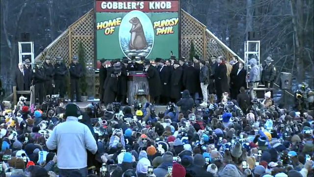
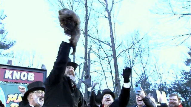
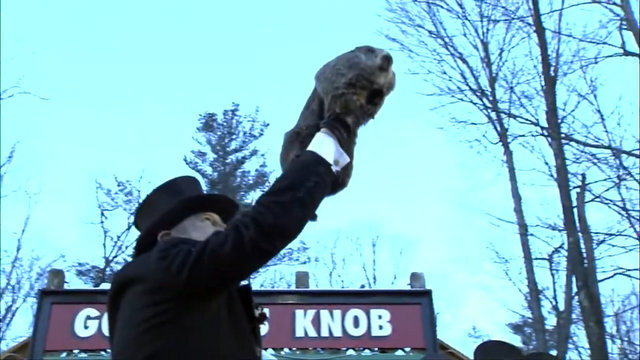
Punxsutawney Phil Predicts Another Six Weeks of Winter
Posted by: thepinetree on 02/02/2023 04:12 PM
Punxsutawney, PA...Hear ye! Hear ye! Now on this February 2nd Punxsutawney Phil, The seer of seers, Was awakened from his wintery nap At dawn on Gobbler’s Knob. Phil looked to the skies and then, Speaking in Groundhogese, Directed this President Dunkel To the proper scroll, which reads.. I see the morning has brought the finest people, I see their bravery and spirit, The time has come – I can feel it, The excitement – I can hear it, I see the folks with gray in their hair, And the kids all young and scrawny, Their eyes and cheeks aglow, From the cold, clean air of sweet Punxsutawney, I see that everyone knows their part, And I am merely the sage, But above all else, I see a SHADOW on my stage! So no matter how you measure, It’s 6 more weeks of winter weather!
Winter Storm Warning on Sunday as a Bit of Snow Heads to Our Way.
Posted by: thepinetree on 01/28/2023 08:11 PM
Arnold, CA...Detailed forecast for from the National Weather Service & Winter Storm Warning for the West Slope Northern Sierra Nevada. Tonight, Mostly clear. Lows 14 to 29 higher elevations...27 to 35 lower elevations. Prevailing south winds up to 15 mph. Gusts up to 30 mph after midnight. Sunday, At lower elevations, patchy dense fog in the morning, a chance of rain showers through the day. A chance of snow showers in the morning, then heavy snow showers likely in the afternoon. Highs 21 to 36 higher elevations...33 to 41 lower elevations. Snow accumulation 2 to 4 inches lower elevations...except 4 to 9 inches higher elevations. Prevailing south winds 5 to 15 mph with gusts to around 30 mph.
County & City Enjoying Respite Following Tornado Touchdown by Lake Hogan, Awaits Inclusion in Governor's State of Emergency
Posted by: thepinetree on 01/11/2023 04:41 PM
San Andreas, CA...County, City, CalTrans, and PG&E emergency operations staff are thankful for a day of respite from working around the clock to keep roadways open, communities safe, and our power running. As of last night, PG&E has restored power to approximately 4,800 customers and power restoration efforts continue.
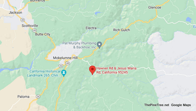
Mokelumne Hill, CA...Please be advised Calaveras County Public Works has issued a complete road closure of Jesus Maria Road at Hawver Road to ½ mile east. The road will be reopened as soon as possible. Please use local detour routes to avoid the impacted area.