| Announcements |
Excessive Heat Watch for Labor Day Weekend Some Areas May See Temps as High as 115 |
|
Posted by: thepinetree on 08/30/2022 11:07 AM
|
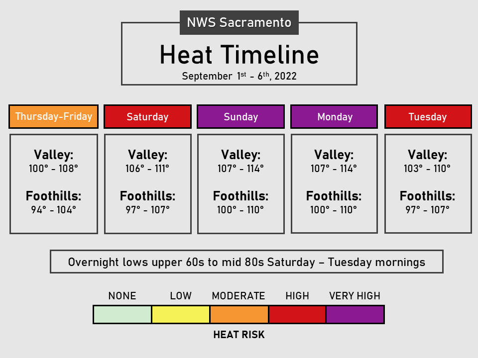
Sacramento, CA...Excessive Heath Watch from Saturday through Tuesday! Extreme heat will significantly increase the potential for heat related illnesses, particularly for those working or participating in outdoor activities over the holiday weekend. Hottest days forecast to occur Sunday and Monday. There will be limited overnight relief from the heat, with lows in the upper 60s to mid 80s.
|
|
Read More
| 8 Comments
|
|
Heat Returns to the West Slope & Mother Lode This Week |
|
Posted by: thepinetree on 08/13/2022 09:11 AM
|
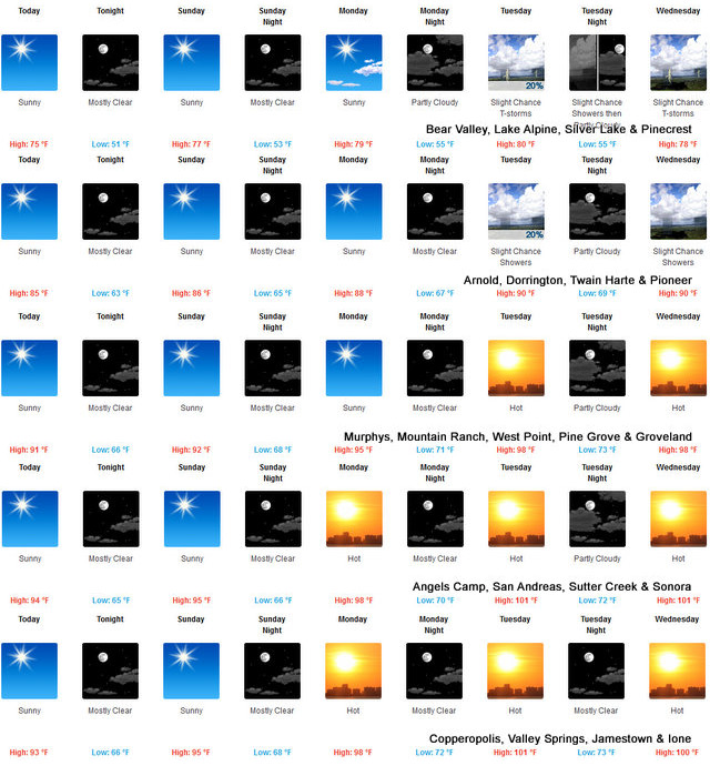
Arnold, CA...The Detailed forecasts for the Mother Lode and West Slope from the National Weather Service are below. Rising temps and chance of thunderstorms in the high country and well just plain ole heat at lower elevations. For West Slope Northern Sierra Nevada Today Sunny. Highs 70 to 85 higher elevations...82 to 92 lower elevations. Prevailing southeast winds up to 10 mph shifting to the southwest in the afternoon. Tonight Clear. Lows 47 to 62 higher elevations...56 to 70 lower elevations. Prevailing southwest winds up to 10 mph shifting to the east after midnight.
|
|
Read More
| 0 Comments
|
|
Perfect Independence Day Weather Ahead for West Slope & Mother Lode! |
|
Posted by: thepinetree on 06/27/2022 01:37 PM
|
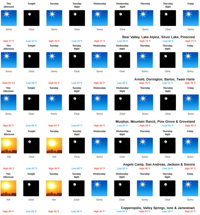
Arnold, CA...Detailed forecast from the National Weather Service for West Slope Northern Sierra Nevada. Today, Sunny. Highs 71 to 86 higher elevations...85 to 95 lower elevations. Prevailing east winds up to 10 mph shifting to the southwest with gusts to around 30 mph in the afternoon. Tonight, Clear. Lows 48 to 63 higher elevations...59 to 71 lower elevations. Prevailing west winds 5 to 15 mph shifting to the southeast after midnight.
 |
|
Read More
| 1 Comments
|
|
Head for the Mountains, Lake or Both as Heat Returns this Week! |
|
Posted by: thepinetree on 06/20/2022 02:40 PM
|
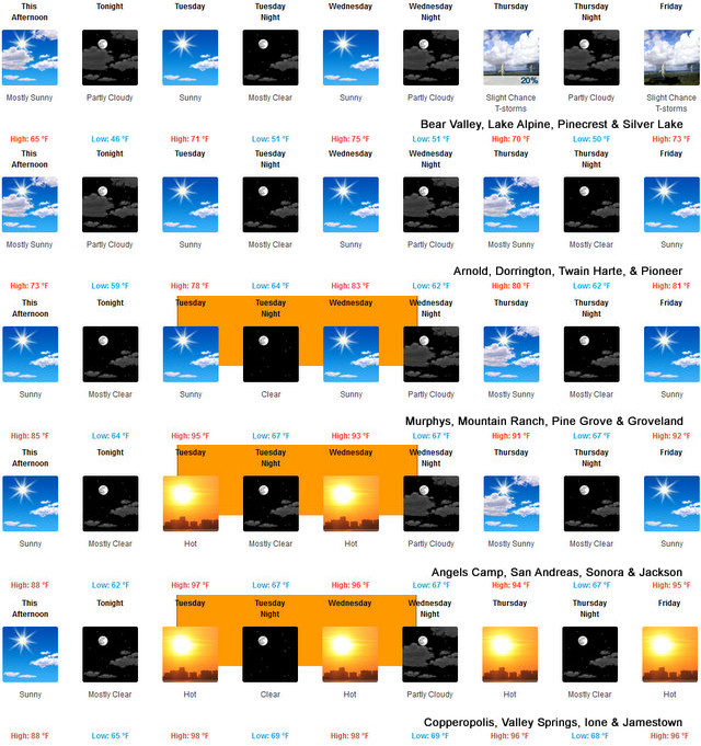
Arnold, CA...Detailed forecast for the West Slope Northern Sierra Nevada from the National Weather Service in Sacramento. Tonight, Mostly cloudy in the evening then clearing. Lows 42 to 57 higher elevations...55 to 67 lower elevations. Prevailing northwest winds up to 10 mph shifting to the east after midnight. Gusts up to 30 mph. Tuesday, Sunny, warmer. Highs 68 to 83 higher elevations... 83 to 93 lower elevations. Prevailing east winds 5 to 15 mph shifting to the south in the afternoon. Gusts up to 30 mph.

|
|
Read More
| 18 Comments
|
|
Video from Kevin Strey of California Outdoor Adventures of this Afternoon's Storm |
|
Posted by: thepinetree on 04/21/2022 10:29 PM
|
Valley Springs, CA...This is Kevin's video from the Valley Springs area during and after the tornado warning and the storm passed through this afternoon.
|
|
| 5 Comments
|
|
Winter Storm Watch Starting Wednesday Afternoon into Thursday |
|
Posted by: thepinetree on 12/06/2021 06:21 PM
|
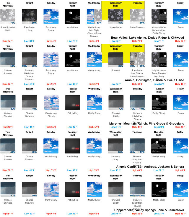
Arnold, CA....The National Weather Service is forecasting a Winter Storm Watch starting Wednesday afternoon..."Winter storm will bring mountain snow late Wednesday afternoon into Thursday. A storm system will approach northern California on Wednesday afternoon, bringing with it accumulating snowfall into Thursday afternoon. Snow levels start out 6000 to 7000 feet falling to 4500 to 5500 feet Thursday morning. The heaviest snow is expected Wednesday night into Thursday morning with the majority of the accumulation above 5500 feet but some light accumulation is possible down to 4500 feet. If you have mountain travel plans be prepared for winter driving conditions, chain controls, and travel delays.
 |
|
Read More
| 1 Comments
|
|
A Beautiful Thanksgiving Weather Week Awaits for West Slope & Mother Lode |
|
Posted by: thepinetree on 11/21/2021 10:20 AM
|
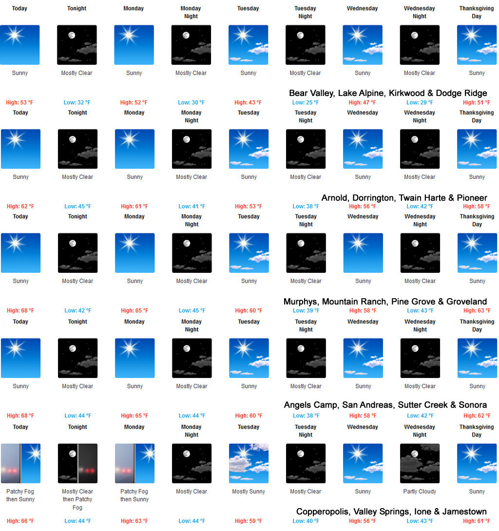
Arnold, CA...The National Weather Service in Sacramento says we have an almost perfect Thanksgiving weather week ahead. The complete forecasts are below...
 |
|
Read More
| 6 Comments
|
|
Red Flag Warning & Blustery Winds Tomorrow Through Tuesday |
|
Posted by: thepinetree on 10/10/2021 10:20 AM
|
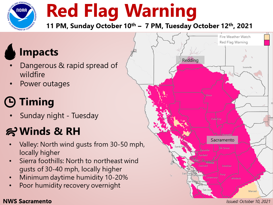
Sacramento, CA...Red Flag Warning late this evening into Tuesday evening for the Central Valley, Coast Range, and the foothill and lower elevations of the southern Cascades...and Monday afternoon into Tuesday evening across the northern Sierra foothills. Gusty north to northeast winds will develop late tonight and continue through Tuesday across much of interior Northern California. The strongest, most impactful, winds are expected on Monday across the Central Valley and foothills of the Coast Range. These winds combined with low humidity and dry fuels will lead to critical fire weather conditions into Tuesday evening.
 |
|
Read More
| 10 Comments
|
|
Red Flag Warning Through August 5th Evening |
|
Posted by: thepinetree on 08/04/2021 10:31 PM
|
Sacramento, CA...The Red Flag Warning has been expanded for portions of Northern California for this afternoon - tomorrow evening. Breezy winds & extremely dry conditions will create critical fire weather conditions. Are you prepared for wildfire? Visit readyforwildfire.org for preparedness tips. The full Red Flag Warning is below...
 |
|
Read More
| 0 Comments
|
|
NWS Issues Excessive Heat Watch for Friday Through Monday! |
|
Posted by: thepinetree on 07/07/2021 08:27 AM
|
Arnold, CA....The latest, updated excessive heat watch from the National Weather Service in Sacramento. "Dangerously hot conditions may impact the Central Valley and surrounding foothills and mountains. Triple digit heat along with warm overnight lows are possible late this week and into early next week. The combination of the very hot afternoons and warm nights will result in a period of high to very high heat risk. Consequently, an Excessive Heat Watch is in effect Friday through Monday evening.
 |
|
Read More
| 0 Comments
|
|


