|
Posted by: thepinetree on 03/12/2022 11:35 AM
Updated by: thepinetree on 03/12/2022 11:35 AM
Expires: 01/01/2027 12:00 AM
:
Well, At Least Some Moisture Heading Our Way this Week.
Arnold, CA...The National Weather Service's latest for forecast for West Slope Northern Sierra Nevada. Today. Sunny. Highs 40 to 55 higher elevations...54 to 64 lower elevations. Prevailing southeast winds up to 10 mph shifting to the southwest in the afternoon. Gusts up to 35 mph. Over ridges... Prevailing southwest winds 10 to 20 mph increasing to 15 to 30 mph in the afternoon. Tonight, Mostly clear in the evening, then mostly cloudy with a chance of rain and snow showers after midnight. Lows 22 to 37 higher elevations...32 to 44 lower elevations. No snow accumulation lower elevations...up to 1 inch higher elevations. Snow level 5000 feet after midnight. Prevailing southwest winds 10 to 20 mph with gusts to around 45 mph...except southwest 20 to 35 mph with gusts to around 50 mph over ridges.
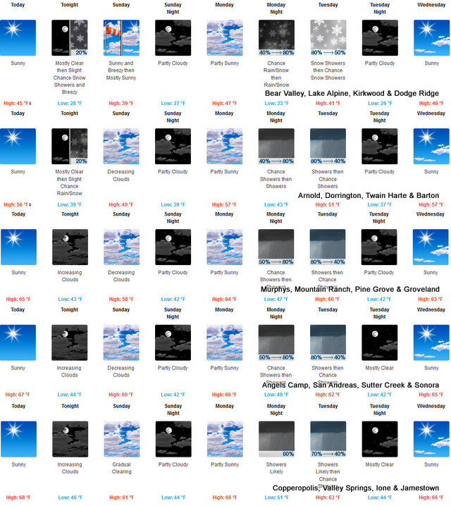
Sunday
Mostly cloudy with a slight chance of rain and snow showers in the morning, then partly cloudy in the afternoon. Highs 33 to 48 higher elevations...45 to 57 lower elevations. No snow accumulation lower elevations...up to 1 inch higher elevations. Snow level 5000 feet. Prevailing southwest winds 10 to 20 mph with gusts to around 40 mph. Over ridges, prevailing southwest winds 25 to 40 mph decreasing to 15 to 30 mph in the afternoon.
Sunday Night
Partly cloudy. Lows 22 to 37 higher elevations... 33 to 45 lower elevations. Prevailing southwest winds up to 10 mph shifting to the east after midnight. Gusts up to 25 mph.
Monday
Mostly cloudy. Not as cool. Highs 42 to 57 higher elevations...53 to 65 lower elevations. Prevailing southeast winds up to 10 mph shifting to the southwest in the afternoon.
Monday Night
Mostly cloudy with a chance of rain and snow showers. Lows 31 to 46.
Tuesday
Mostly cloudy with a chance of rain and snow showers. Highs 40 to 55.
Tuesday Night
Partly cloudy. Colder. Lows 25 to 40.
Wednesday And Wednesday Night
Mostly clear. Highs 46 to 61. Lows 26 to 41.
Thursday
Partly cloudy. Highs 46 to 61.
Thursday Night And Friday
Mostly clear. Lows 28 to 43. Highs 49 to 64.
Detailed forecast for Motherlode
Today
Sunny. Highs 60 to 70. Prevailing southeast winds up to 10 mph shifting to the south in the afternoon.
Tonight
Mostly clear in the evening, then cloudy with a slight chance of rain showers after midnight. Lows 39 to 47. Prevailing south winds up to 15 mph.
Sunday
Cloudy with a slight chance of rain showers in the morning, then partly cloudy in the afternoon. Highs 53 to 63. Prevailing southwest winds up to 10 mph.
Sunday Night
Partly cloudy. Lows 38 to 46. Prevailing west winds up to 10 mph in the evening becoming light.
Monday
Mostly cloudy. Highs 60 to 68. Light winds becoming southwest up to 10 mph in the afternoon.
Monday Night
Mostly cloudy with a chance of rain showers. Lows 44 to 52.
Tuesday
Mostly cloudy with a chance of rain showers. Highs 55 to 65.
Tuesday Night
Mostly clear. Colder. Lows 38 to 46.
Wednesday
Sunny. Highs 61 to 69.
Wednesday Night Through Friday
Mostly clear. Lows 40 to 48. Highs 61 to 71.
|
| Comments - Make a comment |
| The comments are owned by the poster. We are not responsible for its content. We value free speech but remember this is a public forum and we hope that people would use common sense and decency. If you see an offensive comment please email us at news@thepinetree.net
Record Drought
Posted on: 2022-03-12 18:04:24
By: Anonymous
|
|
Please be aware this is a serious drought, this is record drought.
Fires are already breaking out.
Please remember -Only You Can Prevent Fires.
99% of fires are from the general Public-You.
It's early in the usual scheme of things- This aint Normal, this is a historic drought.
Please have a "July mindset" NOW.
A few .5" of rain will just settle the dust.
Please be fire conscious NOW.
[Reply
]
|
Re: Record Drought
Posted on: 2022-03-12 18:11:10
By: Anonymous
|
|
BS the drought is a Hoax.
A Calaveras Citizen.
[Reply
]
|
Re: Record Drought....a hoax
Posted on: 2022-03-12 20:00:25
By: Anonymous
|
|
Must be a dotard that believes the Earth is flat, man never walked on the moon, and Trump won the 2020 elect.
Drought means lack of precipitation over an extended period of time. How can you dispute that we have not had normal precipitation over several years?
[Reply
]
|
|
| What's Related |
| These might interest you as well
Photo Albums
phpws Business Directory
Local News
Calendar
Web Pages
|
|
|


