|
Posted by: thepinetree on 12/02/2014 08:50 AM
Updated by: thepinetree on 12/02/2014 09:00 AM
Expires: 01/01/2019 12:00 AM
:

Rain & Snow Returns & Winter Storm Warning In Effect
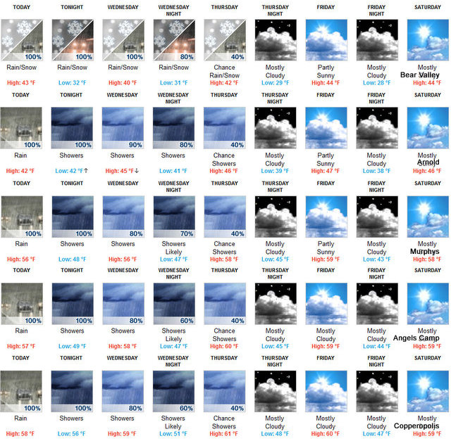
Bear Valley, CA...Today At lower elevations...a chance of rain in the morning... Then rain in the afternoon. At higher elevations...snow and a chance of rain in the morning...then rain and snow in the afternoon. Highs 36 to 50 higher elevations...48 to 54 lower elevations. Snow accumulation up to 2 inches higher elevations. Snow level above 8000 feet. Prevailing southeast winds up to 10 mph...except southeast 10 to 25 mph over ridges. Tonight At lower elevations...rain showers and a slight chance of thunderstorms in the evening...then rain showers after midnight. At higher elevations...rain showers...snow showers and a slight chance of thunderstorms in the evening...then rain and snow showers after midnight. Lows 29 to 43 higher elevations... 41 to 49 lower elevations. Snow accumulation up to 2 inches higher elevations. Snow level above 8000 feet. Prevailing south winds up to 10 mph with gusts to around 25 mph...except south 20 to 35 mph over ridges....
The Latest Weather & Road Conditions Are Always On Our Weather Page
Wednesday At lower elevations...rain showers and a chance of thunderstorms in the morning...then rain showers in the afternoon. At higher elevations...rain and snow showers. Highs 34 to 48 higher elevations...47 to 53 lower elevations. Snow accumulation up to 3 inches higher elevations. Snow level 7000 feet. Prevailing south winds 5 to 15 mph with gusts to around 30 mph. Over ridges...prevailing south winds 25 to 35 mph increasing to 30 to 45 mph in the afternoon. Gusts up to 60 mph over ridges.
Wednesday Night Rain and snow showers. Lows 28 to 42 higher elevations...41 to 47 lower elevations. Snow accumulation up to 2 inches higher elevations. Snow level 7500 feet. Prevailing south winds 5 to 15 mph...except southwest 20 to 35 mph over ridges.
Thursday Mostly cloudy with a chance of rain and snow showers. Highs 36 to 51 higher elevations...49 to 55 lower elevations. Snow accumulation up to 1 inch higher elevations. Snow level 7000 feet. Prevailing south winds up to 10 mph. Over ridges... Prevailing southwest winds 15 to 25 mph decreasing to 5 to 15 mph in the afternoon.
Thursday Night Mostly cloudy with a slight chance of rain showers. Lows 29 to 44.
Friday Mostly cloudy with a slight chance of rain showers. Highs 40 to 55.
Friday Night And Saturday Mostly cloudy with a slight chance of rain showers. Lows 28 to 43. Highs 40 to 55.
Saturday Night And Sunday Partly cloudy. Lows 27 to 42. Highs 41 to 56.
Sunday Night Partly cloudy with a slight chance of rain showers. Lows 28 to 43.
Monday Mostly cloudy. Highs 42 to 57.
Winter Storm Warning
URGENT - WINTER WEATHER MESSAGE
NATIONAL WEATHER SERVICE SACRAMENTO CA
330 AM PST TUE DEC 2 2014
CAZ068-069-030000-
/O.CON.KSTO.WS.W.0009.141202T2000Z-141204T1200Z/
WESTERN PLUMAS COUNTY/LASSEN PARK-
WEST SLOPE NORTHERN SIERRA NEVADA-
330 AM PST TUE DEC 2 2014
...WINTER STORM WARNING REMAINS IN EFFECT FROM NOON TODAY TO 4 AM
PST THURSDAY ABOVE 7000 FEET FOR THE WEST SLOPES OF THE NORTHERN
SIERRA NEVADA AND LASSEN NATIONAL PARK...
* IMPACTS: TRAVELERS MAY EXPERIENCE DELAYS. CHAIN RESTRICTIONS
LIKELY THROUGH THE PASSES.
* CONFIDENCE: HIGH.
* TIMING: A STRONG WINTER STORM WILL BEGIN TO AFFECT THE REGION
TODAY AND WILL CONTINUE INTO THURSDAY. THE PERIOD OF HEAVIEST
SNOWFALL IS EXPECTED TONIGHT AND WEDNESDAY.
* LOCATIONS INCLUDE: DONNER PASS...ECHO SUMMIT...CARSON PASS.
* SNOW ACCUMULATIONS: 12 TO 18 INCHES WITH 2 TO 3 FEET OVER THE
HIGHER PEAKS.
* FOR A DETAILED VIEW OF THE HAZARD AREA...VISIT
HTTP://WWW.WEATHER.GOV/SACRAMENTO/HAZARDS.
PRECAUTIONARY/PREPAREDNESS ACTIONS...
A WINTER STORM WARNING FOR HEAVY SNOW MEANS SEVERE WINTER WEATHER
CONDITIONS ARE EXPECTED OR OCCURRING. SIGNIFICANT AMOUNTS OF SNOW
ARE FORECAST THAT WILL MAKE TRAVEL DIFFICULT. IF YOU MUST
TRAVEL...KEEP AN EXTRA FLASHLIGHT...FOOD...AND WATER IN YOUR
VEHICLE IN CASE OF AN EMERGENCY.
&&
INTERACT WITH US VIA SOCIAL MEDIA
WWW.FACEBOOK.COM/NWS.SACRAMENTO
WWW.TWITTER.COM/NWSSACRAMENTO
$$
|
| Comments - Make a comment |
| The comments are owned by the poster. We are not responsible for its content. We value free speech but remember this is a public forum and we hope that people would use common sense and decency. If you see an offensive comment please email us at news@thepinetree.net
|
| What's Related |
| These might interest you as well
Photo Albums
phpws Business Directory
Local News
- Big Trees Market Weekly Ad, Grocery, Produce, Meat & Deli Specials Thr...
- Big Trees Market Weekly Ad, Grocery, Produce, Meat & Deli Specials Thr...
- Mornings with the One Percent™ Classic Rewind, The 2018 Arnold Indep...
- Make Plans to Visit Hinterhaus Many Times This Summer
- The Perfect Bike for You Awaits at Bear Valley Bicycles! Shop or Rent...
- Chapel in the Pines Sunday Service, June 2nd, 2024
- Home Invasion Leads to Violent Confrontation.
- Arnold Chevron & Deli, Eat Where the Locals Eat! Order Lunch Today at ...
- Al Reita Painter 1946 ~ 2024
- California State Parks Plans Prescribed Burn at Calaveras Big Trees State...
- Some Summer Offices are Better Than Others! Make Bear Lake Yours!
- Your High Country Adventures Await with Boat Rentals from BVAC!
- Big Trees Market Weekly Ad, Grocery, Produce, Meat & Deli Specials Thr...
- Your High Country Adventures Await with Boat Rentals from BVAC!
- Big Trees Market Weekly Ad, Grocery, Produce, Meat & Deli Specials Thr...
- Big Trees Market Weekly Ad, Grocery, Produce, Meat & Deli Specials Thr...
- Big Trees Market Weekly Ad, Grocery, Produce, Meat & Deli Specials Thr...
- Big Trees Market Weekly Ad, Grocery, Produce, Meat & Deli Specials Thr...
Calendar
Web Pages
Link Manager
|
|
|


