|
Posted by: John_Hamilton on 08/10/2012 12:53 PM
Updated by: John_Hamilton on 08/10/2012 12:55 PM
Expires: 01/01/2017 12:00 AM
:
Head for The Lakes and Hills...Hot Weekend Ahead
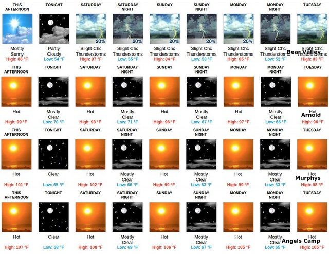
Bear Valley, CA...With the heat that is upon us it may be time to head for the hills and lakes and get cooled off. Following this is the Bear Valley forecast and the Muphys forecast including weather warnings is enclosed. This Afternoon Mostly sunny, with a high near 86. Southwest wind 13 to 16 mph, with gusts as high as 24 mph. Tonight Partly cloudy, with a low around 54. West southwest wind 9 to 14 mph becoming light and variable. Winds could gust as high as 21 mph. Saturday A 20 percent chance of showers and thunderstorms after 11am. Mostly sunny, with a high near 87. Southeast wind 5 to 13 mph becoming southwest in the afternoon. Winds could gust as high as 20 mph. New rainfall amounts of less than a tenth of an inch, except higher amounts possible in thunderstorms. Saturday Night A 20 percent chance of showers and thunderstorms before 11pm. Partly cloudy, with a low around 55. West southwest wind 5 to 10 mph becoming light and variable in the evening....

Sunday A 20 percent chance of showers and thunderstorms after 11am. Mostly sunny, with a high near 84. Calm wind becoming west southwest 5 to 9 mph in the afternoon.
Sunday Night A 20 percent chance of showers and thunderstorms before 11pm. Partly cloudy, with a low around 53.
Monday A 20 percent chance of showers and thunderstorms after 11am. Mostly sunny, with a high near 85.
Monday Night A slight chance of showers and thunderstorms. Partly cloudy, with a low around 52.
Tuesday A slight chance of showers and thunderstorms. Mostly sunny, with a high near 83.
Tuesday Night A slight chance of showers and thunderstorms. Partly cloudy, with a low around 50.
Wednesday A slight chance of showers and thunderstorms. Mostly sunny, with a high near 82.
Wednesday Night A slight chance of showers and thunderstorms. Partly cloudy, with a low around 51.
Thursday Mostly sunny, with a high near 81.
Murphys, CA...
7-DAY FORECAST
This Afternoon Sunny and hot, with a high near 101. West southwest wind 7 to 9 mph.
Tonight Clear, with a low around 65. West wind 5 to 9 mph becoming east after midnight.
Saturday Sunny and hot, with a high near 102. East wind 5 to 7 mph becoming southwest in the afternoon.
Saturday Night Mostly clear, with a low around 66. West wind around 7 mph becoming northeast in the evening.
Sunday Sunny and hot, with a high near 99. East northeast wind 5 to 8 mph becoming west southwest in the morning.
Sunday Night Mostly clear, with a low around 63.
Monday Sunny and hot, with a high near 99.
Monday Night Mostly clear, with a low around 63.
Tuesday Sunny and hot, with a high near 98.
Tuesday Night Mostly clear, with a low around 62.
Wednesday Sunny and hot, with a high near 98.
Wednesday Night Mostly clear, with a low around 61.
Thursday Sunny, with a high near 95.
Special Weather Statement
SPECIAL WEATHER STATEMENT
NATIONAL WEATHER SERVICE SACRAMENTO CA
424 AM PDT FRI AUG 10 2012
CAZ013>019-063-064-066>069-111130-
SHASTA LAKE AREA / NORTHERN SHASTA COUNTY-
BURNEY BASIN / EASTERN SHASTA COUNTY-NORTHERN SACRAMENTO VALLEY-
CENTRAL SACRAMENTO VALLEY-SOUTHERN SACRAMENTO VALLEY-
CARQUINEZ STRAIT AND DELTA-NORTHERN SAN JOAQUIN VALLEY-
MOUNTAINS SOUTHWESTERN SHASTA COUNTY TO NORTHERN LAKE COUNTY-
CLEAR LAKE/SOUTHERN LAKE COUNTY-
NORTHEAST FOOTHILLS/SACRAMENTO VALLEY-MOTHERLODE-
WESTERN PLUMAS COUNTY/LASSEN PARK-
WEST SLOPE NORTHERN SIERRA NEVADA-
424 AM PDT FRI AUG 10 2012
...HOT WEATHER FOR INTERIOR NORTHERN CALIFORNIA INTO NEXT WEEK...
STRONG HIGH PRESSURE WILL REMAIN OVER NORTHERN CALIFORNIA THROUGH
THE WEEKEND. THIS WILL RESULT IN A PROLONGED PERIOD OF HOT
TEMPERATURES FOR THE REGION POTENTIALLY LASTING INTO NEXT WEEK.
CURRENT FORECASTS INDICATE THE HOTTEST DAYS WILL BE TODAY AND
SATURDAY WHEN HIGHS IN THE CENTRAL VALLEY ARE EXPECTED TO RANGE
FROM 105 TO 110 WITH TEMPERATURES IN THE MOUNTAINS IN THE 80S AND
90S. OVERNIGHT MINIMUM TEMPERATURES WILL ALSO BE WARM WITH VALLEY
READINGS IN THE MID 60S TO LOWER 70S WITH MAINLY 50S AND 60S IN
THE MOUNTAINS. WARMER FOOTHILL LOCALES MAY SEE SEVERAL DAYS WITH
OVERNIGHT MINIMUMS ONLY IN THE 70S.
HOT WEATHER SAFETY TIPS...
1. DRINK PLENTY OF WATER.
2. AVOID STRENUOUS ACTIVITY DURING THE HOTTEST PART OF THE DAY.
3. NEVER LEAVE CHILDREN OR PETS UNATTENDED IN A VEHICLE.
4. WEAR LIGHT WEIGHT AND LIGHT COLORED CLOTHING.
$$
Hazardous Weather Outlook
HAZARDOUS WEATHER OUTLOOK
NATIONAL WEATHER SERVICE SACRAMENTO CA
426 AM PDT FRI AUG 10 2012
CAZ013>019-063-064-066>069-111130-
SHASTA LAKE AREA / NORTHERN SHASTA COUNTY-
BURNEY BASIN / EASTERN SHASTA COUNTY-NORTHERN SACRAMENTO VALLEY-
CENTRAL SACRAMENTO VALLEY-SOUTHERN SACRAMENTO VALLEY-
CARQUINEZ STRAIT AND DELTA-NORTHERN SAN JOAQUIN VALLEY-
MOUNTAINS SOUTHWESTERN SHASTA COUNTY TO NORTHERN LAKE COUNTY-
CLEAR LAKE/SOUTHERN LAKE COUNTY-
NORTHEAST FOOTHILLS/SACRAMENTO VALLEY-MOTHERLODE-
WESTERN PLUMAS COUNTY/LASSEN PARK-
WEST SLOPE NORTHERN SIERRA NEVADA-
426 AM PDT FRI AUG 10 2012
THIS HAZARDOUS WEATHER OUTLOOK IS FOR PORTIONS OF NORTHERN
CALIFORNIA.
.DAY ONE...TODAY AND TONIGHT
HOT TEMPERATURES FOR THE AREA TODAY.
.DAYS TWO THROUGH SEVEN...SATURDAY THROUGH THURSDAY
HOT WEATHER WILL CONTINUE INTO THE WEEKEND. MODELS INDICATE A
COOLING TREND BY THE MIDDLE OF NEXT WEEK.
NO HAZARDOUS WEATHER IS EXPECTED AT THIS TIME.
.SPOTTER INFORMATION STATEMENT...
SPOTTER ACTIVATION WILL NOT BE NEEDED.
$$
|
| Comments - Make a comment |
| The comments are owned by the poster. We are not responsible for its content. We value free speech but remember this is a public forum and we hope that people would use common sense and decency. If you see an offensive comment please email us at news@thepinetree.net
|
| What's Related |
| These might interest you as well
Photo Albums
phpws Business Directory
Local News
Calendar
Link Manager
Web Pages
|
|
|


