|
Posted by: thepinetree on 03/22/2024 10:30 PM
Updated by: thepinetree on 03/22/2024 10:30 PM
Expires: 01/01/2029 12:00 AM
:
Up to 4 Feet of Snow at Higher Elevations & Storm Warning till Sunday Morning.
Arnold, CA....Well is may not be this year's "Snow on the Dogwoods" but we are getting close. Possibly up to 4 feet of snow at higher elevations. Full forecasts for the West Slope & Mother Lode are below...
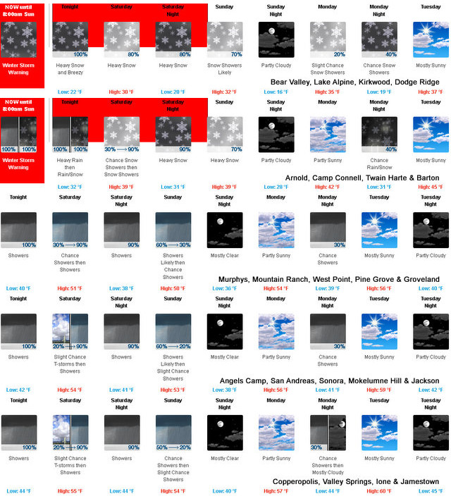
Detailed forecast for
West Slope Northern Sierra Nevada
Today
Partly cloudy until late afternoon, then partly cloudy with a chance of rain showers late in the afternoon. Highs 39 to 54 higher elevations...51 to 63 lower elevations. Snow level 7500 feet in the afternoon. Prevailing south winds up to 20 mph with gusts to around 35 mph. Over ridges, prevailing southwest winds 10 to 20 mph increasing to 20 to 35 mph in the afternoon.
Tonight
At lower elevations, heavy rain showers and a chance of thunderstorms in the evening, then rain showers, a chance of thunderstorms and heavy snow showers after midnight. At higher elevations, rain showers, heavy snow showers and a slight chance of thunderstorms. Breezy, colder. Lows 17 to 31 higher elevations...28 to 40 lower elevations. Little or no snow accumulation lower elevations...8 to 14 inches higher elevations. Snow level 7500 feet decreasing to 5500 feet after midnight. Prevailing southwest winds 15 to 25 mph decreasing to 5 to 15 mph after midnight. Gusts up to 40 mph. Over ridges...prevailing southwest winds 20 to 35 mph.
Saturday
Mostly cloudy. A chance of snow showers in the morning, then rain showers with possible snow showers and thunderstorms in the afternoon. Highs 26 to 41 higher elevations...37 to 49 lower elevations. Snow accumulation up to 1 inch lower elevations...except 3 to 6 inches higher elevations. Snow level 4500 feet. Prevailing south winds 5 to 15 mph with gusts to around 30 mph...except southwest 10 to 30 mph over ridges.
Saturday Night
Heavy snow showers, rain showers and a slight chance of thunderstorms in the evening, then heavy rain and snow showers after midnight. Lows 17 to 32 higher elevations...30 to 38 lower elevations. Snow accumulation up to 3 inches lower elevations...except 6 to 12 inches higher elevations. Snow level 4000 feet. Prevailing southwest winds 5 to 15 mph with gusts to around 30 mph...except southwest 10 to 30 mph over ridges.
Sunday
Mostly cloudy. Snow showers likely in the morning, then a chance of rain and snow showers in the afternoon. Highs 28 to 43 higher elevations...39 to 49 lower elevations. Snow accumulation up to 2 inches lower elevations...except 2 to 5 inches higher elevations. Snow level 4000 feet. Prevailing west winds up to 10 mph.
Sunday Night
Partly cloudy. Colder. Lows 17 to 32.
Monday
Mostly cloudy with a slight chance of snow showers. Not as cool. Highs 34 to 49.
Monday Night
Mostly cloudy with a chance of rain and snow showers. Lows 21 to 36.
Tuesday
Partly cloudy with a slight chance of snow showers. Highs 36 to 51.
Tuesday Night
Partly cloudy. Lows 22 to 37.
Wednesday
Mostly cloudy with a chance of rain and snow showers. Highs 37 to 52.
Wednesday Night And Thursday
Rain and snow showers likely. Breezy. Heavy snow accumulations possible. Lows 23 to 38. Highs 34 to 49.
Detailed forecast for
Motherlode
Today
Partly cloudy until late afternoon, then partly cloudy with a slight chance of showers and thunderstorms late in the afternoon. Highs 58 to 70. Prevailing southeast winds up to 15 mph.
Tonight
Rain showers and a chance of thunderstorms. Colder. Lows 35 to 45. Prevailing southwest winds up to 15 mph.
Saturday
Mostly cloudy. A slight chance of rain showers in the morning, then rain showers and a slight chance of thunderstorms in the afternoon. Highs 43 to 53 higher elevations...48 to 58 lower elevations. Prevailing southeast winds up to 10 mph shifting to the south in the afternoon.
Saturday Night
Rain showers and a chance of thunderstorms in the evening, then rain showers and a slight chance of thunderstorms after midnight. Lows 35 to 45. Prevailing south winds up to 10 mph.
Sunday
Mostly cloudy. A chance of rain showers in the morning, then a slight chance of rain showers in the afternoon. Highs 46 to 58. Prevailing southeast winds up to 10 mph shifting to the southwest in the afternoon.
Sunday Night
Mostly clear. Lows 33 to 41.
Monday
Mostly cloudy with a slight chance of rain showers. Highs 48 to 60.
Monday Night
Mostly cloudy with a chance of rain showers. Lows 36 to 44.
Tuesday And Tuesday Night
Partly cloudy. Highs 52 to 64. Lows 36 to 45.
Wednesday
Mostly cloudy with a chance of rain showers. Highs 51 to 63.
Wednesday Night And Thursday
Rain showers likely. Lows 38 to 46. Highs 47 to 62.
Winter Storm Warning
URGENT - WINTER WEATHER MESSAGE
National Weather Service Sacramento CA
110 PM PDT Fri Mar 22 2024
CAZ069-231400-
/O.CON.KSTO.WS.W.0013.240323T0100Z-240324T1500Z/
West Slope Northern Sierra Nevada-
Including the city of Blue Canyon
110 PM PDT Fri Mar 22 2024
...WINTER STORM WARNING REMAINS IN EFFECT FROM 6 PM PDT THIS
EVENING TO 8 AM PDT SUNDAY...
* WHAT...Heavy snow. Total snow accumulations of 1 to 2 feet, with
3 to 4 feet over the higher peaks. Winds gusting as high as 45
mph.
* WHERE...West Slope Northern Sierra Nevada above 4000 feet.
* WHEN...From 6 PM PDT this evening to 8 AM PDT Sunday.
* IMPACTS...Travel could be very difficult from delays, snow-
covered roads, and chain controls. Gusty winds could bring down
tree branches.
* ADDITIONAL DETAILS...Snow levels 6000 to 7000 feet, lowering to
3500 to 4500 feet early Saturday morning and continuing through
Sunday. Snow rates of 1 to 3 inches per hour expected, heaviest
tonight into early Saturday morning.
PRECAUTIONARY/PREPAREDNESS ACTIONS...
If you must travel, keep an extra flashlight, food, and water in
your vehicle in case of an emergency.
The latest road conditions for the state you are calling from can
be obtained by calling 5 1 1.
|
| Comments - Make a comment |
| The comments are owned by the poster. We are not responsible for its content. We value free speech but remember this is a public forum and we hope that people would use common sense and decency. If you see an offensive comment please email us at news@thepinetree.net
|
| What's Related |
| These might interest you as well
Local News
Photo Albums
phpws Business Directory
Calendar
Web Pages
Link Manager
|
|
|


