Posted by: thepinetree on 02/04/2024 02:16 PM
Updated by: thepinetree on 02/04/2024 02:16 PM
Expires: 01/01/2029 12:00 AM
:
Mother Nature Playing Catch Up! Up to 6 Feet of Snow at Higher Elevations & Flood Watch at Lower Elevations
Arnold, CA...Heavy snow. Additional snow accumulations of snow accumulations of 1 to 3 feet expected with up to 6 feet at the higher mountain peaks. 2 to 8 inches of snow down to 4500 feet. Winds gusting as high as 85 mph.
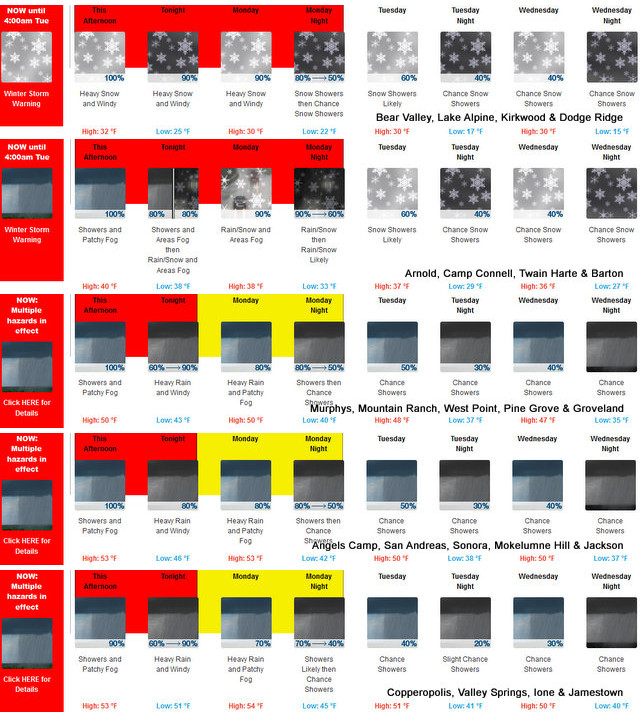

Winter Storm Warning
URGENT - WINTER WEATHER MESSAGE
National Weather Service Sacramento CA
152 PM PST Sun Feb 4 2024
CAZ014-068-069-051430-
/O.CON.KSTO.WS.W.0007.000000T0000Z-240206T1200Z/
Burney Basin / Eastern Shasta County-
Western Plumas County/Lassen Park-
West Slope Northern Sierra Nevada-
Including the cities of Burney, Chester, Quincy, and Blue Canyon
152 PM PST Sun Feb 4 2024
...WINTER STORM WARNING REMAINS IN EFFECT UNTIL 4 AM PST
TUESDAY...
* WHAT...Heavy snow. Additional snow accumulations of snow
accumulations of 1 to 3 feet expected with up to 6 feet at the
higher mountain peaks. 2 to 8 inches of snow down to 4500 feet.
Winds gusting as high as 85 mph.
* WHERE...Western Plumas County/Lassen Park and West Slope
Northern Sierra Nevada, including Interstate 80 over Donner
Pass and Highway 50 over Echo Summit.
* WHEN...Until 4 AM PST Tuesday.
* IMPACTS...Travel could be very difficult to impossible. The
hazardous conditions could impact the morning or evening
commute. Very strong winds could cause extensive tree damage.
* ADDITIONAL DETAILS...Snow levels will be around 5500 to 7000
feet this afternoon, and 4500 to 5500 feet on Monday. Heaviest
snowfall will be today, with snow rates of 1 to 3 inches per
hour. Highest accumulations above 6000 feet.
PRECAUTIONARY/PREPAREDNESS ACTIONS...
If you must travel, keep an extra flashlight, food, and water in
your vehicle in case of an emergency.
The latest road conditions for the state you are calling from can
be obtained by calling 5 1 1.
Flood Watch
Flood Watch
National Weather Service Sacramento CA
1207 AM PST Sun Feb 4 2024
CAZ015>019-066-067-050000-
/O.CON.KSTO.FA.A.0003.240204T1400Z-240206T1200Z/
/00000.0.ER.000000T0000Z.000000T0000Z.000000T0000Z.OO/
Northern Sacramento Valley-Central Sacramento Valley-Southern
Sacramento Valley-Carquinez Strait and Delta-Northern San Joaquin
Valley-Northeast Foothills/Sacramento Valley-Motherlode-
Including the cities of Oroville, Fairfield/Suisun, Redding,
Marysville/Yuba City, Modesto, Red Bluff, Paradise, Stockton,
Sacramento, Jackson, Chico, and Grass Valley
1207 AM PST Sun Feb 4 2024
...FLOOD WATCH REMAINS IN EFFECT FROM 6 AM PST THIS MORNING THROUGH
EARLY TUESDAY MORNING...
* WHAT...Flooding caused by excessive rainfall is possible.
* WHERE...A portion of northern California, including the following
areas, Carquinez Strait and Delta, Sacramento Valley, Motherlode,
Northeast Foothills, Northern San Joaquin Valley.
* WHEN...From 6 AM PST this morning through early Tuesday morning.
* IMPACTS...Excessive runoff may result in flooding of rivers,
creeks, streams, and other low-lying and flood-prone locations.
Creeks and streams may rise out of their banks. Flooding may occur
in poor drainage and urban areas. Low-water crossings may be
flooded. Storm drains and ditches may become clogged with debris.
* ADDITIONAL DETAILS...
- Moderate to heavy rain will move through the region today
and Monday, resulting in the potential for urban and small
stream flooding. Renewed rises expected along mainstem
rivers.
- http://www.weather.gov/safety/flood
PRECAUTIONARY/PREPAREDNESS ACTIONS...
You should monitor later forecasts and be alert for possible Flood
Warnings. Those living in areas prone to flooding should be prepared
to take action should flooding develop.
&&
High Wind Warning
URGENT - WEATHER MESSAGE
National Weather Service Sacramento CA
1258 PM PST Sun Feb 4 2024
CAZ017>019-067-051200-
/O.CON.KSTO.HW.W.0001.000000T0000Z-240205T1200Z/
Southern Sacramento Valley-Carquinez Strait and Delta-
Northern San Joaquin Valley-Motherlode-
Including the cities of Sacramento, Fairfield/Suisun, Stockton,
Modesto, Grass Valley, and Jackson
1258 PM PST Sun Feb 4 2024
...HIGH WIND WARNING REMAINS IN EFFECT UNTIL 4 AM PST MONDAY...
* WHAT...Southeast winds 30 to 45 mph with gusts 50 to 60 mph
expected. Local gusts up to 70 mph are possible.
* WHERE...Southern Sacramento Valley, Carquinez Strait and Delta,
Northern San Joaquin Valley and Motherlode.
* WHEN...Until 4 AM PST Monday.
* IMPACTS...Damaging winds will blow down trees and power lines.
Widespread power outages are expected. Travel will be
difficult, especially for high profile vehicles.
* ADDITIONAL DETAILS...Gusty winds will continue to spread from
south to north today. The strongest winds are expected this
afternoon through the evening hours.
PRECAUTIONARY/PREPAREDNESS ACTIONS...
People should avoid being outside in forested areas and around
trees and branches. If possible, remain in the lower levels of
your home during the windstorm, and avoid windows. Use caution if
you must drive.
|


