Posted by: thepinetree on 09/19/2022 11:35 AM
Updated by: thepinetree on 09/19/2022 11:35 AM
Expires: 01/01/2027 12:00 AM
:
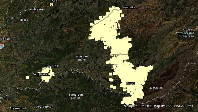
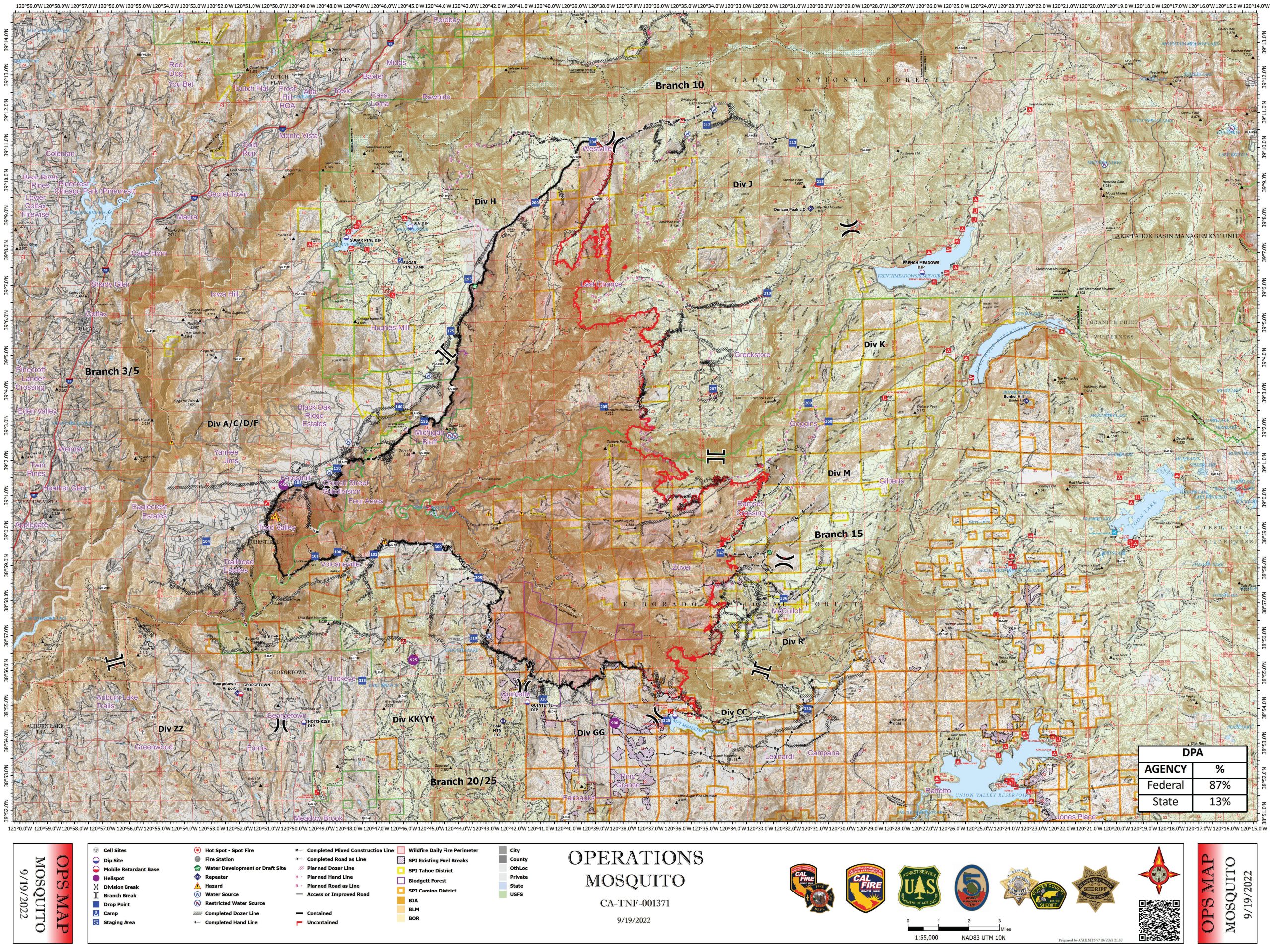
Mosquito Fire Now 76,290 Acres, 39% Contained & Repopulation Accelerating
Foresthill, CA...Repopulation is occurring in some previously evacuated areas in Placer and El Dorado counties. Read the news releases under the announcements tab or view the interactive maps online (links below) for the current status of all evacuation zones. Widespread rain over the fire area continues to reduce fire behavior, but warm, dry weather will return at the end of the week. Fire activity has slowed down, but the firefighters have not. While the rain presents a different set of challenges to the fire-suppression effort, crews continue to work, taking advantage of the lull in fire activity to secure the fire perimeter and increase containment before warm, dry weather returns. They realize many people remain under evacuation orders, and they want to make it safe for everyone to return to their property as soon as possible. For a detailed briefing on the current weather, fire behavior, and fire-suppression accomplishments and plans, watch the daily briefing video (usually posted around 8:30 AM) and read the morning update (article highlighted above).
Evacuations:
Several evacuation orders and warnings in Placer and El Dorado counties have changed recently; however, many orders and warnings remain in effect. Your county's live interactive map is the best place to view the status of evacuation zones, the zone boundaries, and where your property is in relation to them.
Placer County evacuation map (- - changes made on 09-18-22 - - )
El Dorado County evacuation map (- - changes made on 09-18-22 - -)
The decision to evacuate or repopulate a community is not taken lightly. Everyone involved in the decision-making process understands the inconvenience of evacuations and your need to return to homes, communities, and jobs. Obviously, public safety is the priority and informs the decision to evacuate or repopulate an area. The incident management team, incident commanders, county sheriffs, and cooperators meet daily, communicate frequently, and continually assess the evacuation situation. Information will be quickly disseminated when decisions are made to issue or rescind evacuation orders or warnings.
Other Resources:
Mosquito Fire meeting and briefing videos: YouTube
Mosquito Fire photos and videos: Media Assets
Daily Smoke Outlook: English | Español
Rubicon Jeep Trail Closure: Tahoe National Forest | Lake Tahoe Basin Management Unit
Tahoe National Forest: Closure Orders & Maps | Fire Restrictions | Facebook | Twitter
Eldorado National Forest: Closure Orders & Maps | Fire Restrictions | Facebook | Twitter
CAL FIRE AEU: Facebook | Twitter
CAL FIRE NEU: Facebook | Twitter
Placer County: Mosquito Fire Information | Facebook | Twitter
El Dorado County: Mosquito Fire Information | Facebook | Twitter
Damage Assessments:
In both Placer and El Dorado counties, Damage Inspection Specialist (DINS) Teams have completed assessments of all structures within the Mosquito Fire perimeter. The status of each structure can be found on either Placer County’s interactive map or El Dorado County’s interactive map.
Background:
The Mosquito Fire was detected the evening of Tuesday, September 6, and is actively burning east of Foresthill, California, predominantly on the Tahoe and Eldorado National Forests in Placer and El Dorado counties, respectively. The vegetation consists mainly of brush and timber, and the landscape in most places is very steep and rugged. Repopulation of some evacuated communities has begun; however numerous communities in both counties remain under evacuation orders and warnings. Road closures, National Forest closures, and fire restrictions are in effect. California Interagency Incident Management Team 5, a Type 1 team, is managing the fire in unified command with CAL FIRE and Placer County Sheriff's Office.
Source = USFS/Inciweb
|


