Posted by: thepinetree on 09/21/2021 03:00 PM
Updated by: thepinetree on 09/21/2021 03:03 PM
Expires: 01/01/2026 12:00 AM
:
Caldor Post-Fire BAER Soil Burn Severity Map Released
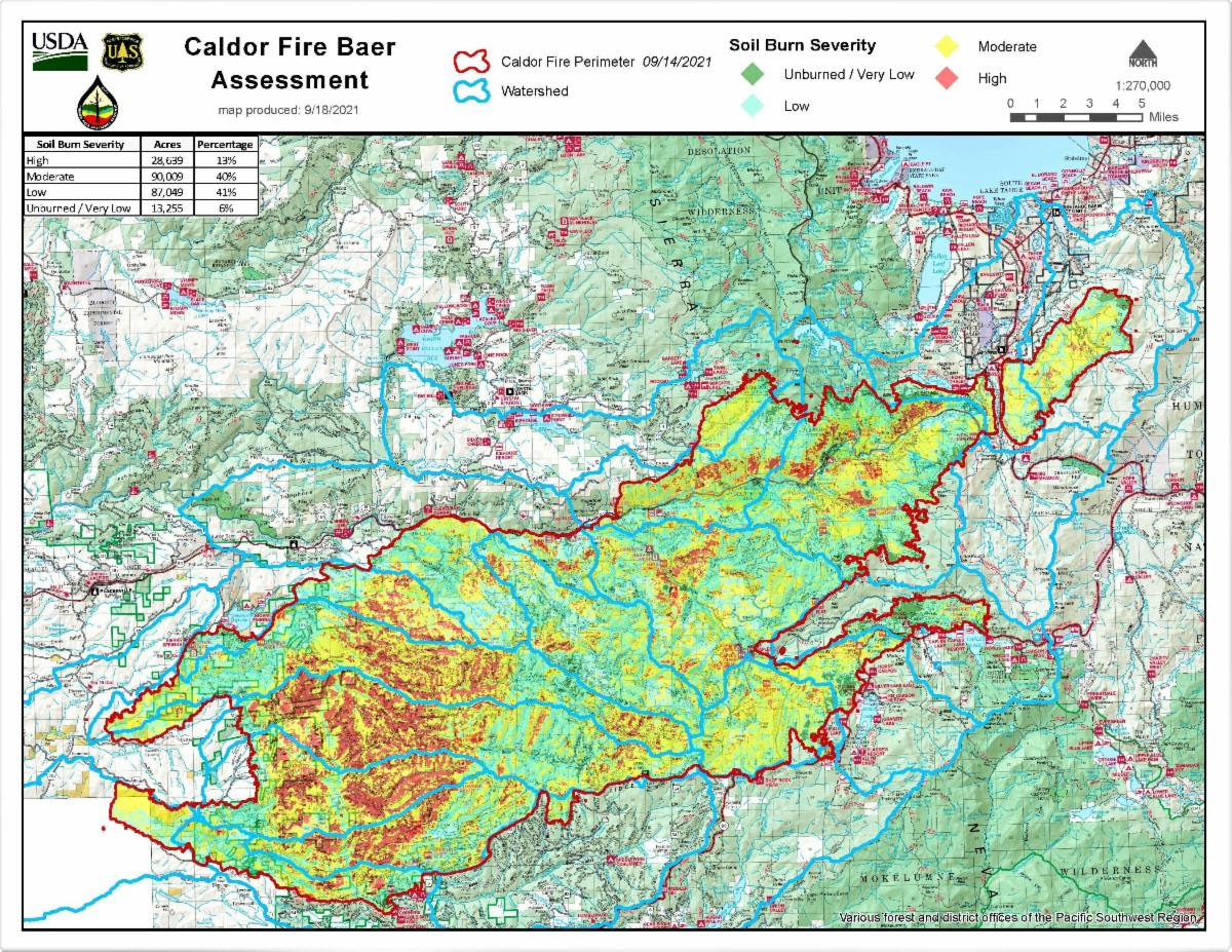
Placerville, CA...USDA Forest Service Burned Area Emergency Response Team (BAER) specialists recently completed their data gathering and analysis of the Caldor burned area to produce a Soil Burn Severity (SBS) map of the 218,952-acre fire.
USDA Forest Service Burned Area Emergency Response (BAER) assessment teams are multi-disciplinary teams sent to federal lands following significant wildfires to characterize the fire effects to watersheds, identify imminent post-fire threats to human life and safety, property, infrastructure, and critical natural and cultural resources. Once the assessment is complete, the team develops BAER emergency treatment recommendations to mitigate identified risks. BAER implementation teams are then brought in after the assessment to implement its recommended treatments and action stabilization measures. These teams begin their assessment immediately after the fire threat passes. The team focuses on the direct damage caused by the fire, rather than from fire suppression activities. Post-fire conditions such as loss of vegetation and the changes in the soils will increase the likelihood of floods and may cause potential debris and sediment flow impacts.
For complex fires such as the Caldor Fire, assessments are done as an inter-agency effort which includes a California State Watershed Emergency Response Team (WERT) ( Watershed Emergency Response Team (acwi.gov). The CalFire WERT assessment team is currently evaluating burned private and state lands from the Caldor Fire. Both assessment teams share information and data as they complete their burned area evaluations, analysis and subsequent reports. The teams also collaborate with other agency, utility and private entities.
BAER specialists recently completed their data gathering and analysis of the Caldor burned area to produce a Soil Burn Severity (SBS) map of the 218,952-acre fire. The map and the data display SBS categories of burn severity to include Unburned/Very Low, Low, Moderate, and High. Approximately 47% of the 218,952 acres are either Unburned/Very Low and/or Low SBS, while 40% sustained a Moderate SBS, and about 13% High SBS.
It is important to note that the BAER team assesses the effects to soils and not the effects to vegetation. Soil burn severity characterizes the effects at the soil surface and below-ground whereas vegetation effects are determined based on mortality and vegetation canopy changes. Forest Service silviculture and ecology specialists will be assessing the effects of the fire on the vegetation burned by the Caldor Fire.
Changes in soil cover, water repellency, and soil physical/biological changes determine the severity level of soil burn severity. Changes in water repellency is a much-discussed fire effect. Water repellency is a natural soil property. Fire can increase the severity and the thickness of the water repellent soil which has significant effects to post-fire water runoff.
Low SBS indicates there was only partial consumption of fine fuels while litter coverage remains relatively intact on the soil surface. Burning time at the soil surface was short, leaving root systems and root structure undamaged. Vegetative recovery time in the low category will vary based on ecological community but is expected to recover in the short-term.
Moderate SBS indicates nearly all soil cover of vegetative litter and fine fuels was consumed or converted to ash. Because soil cover is significantly reduced, accelerated water runoff is expected. Charring of the mineral soil occurs in Moderate SBS as well as shallow root burning. The extent of the burning of the leaves and needles on the trees (aka tree canopy) can be unpredictable and can range from high to relatively low mortality. Water repellency is often found at the surface and is increased for both in severity and thickness of the water repellent soils which reduces the ability of precipitation to infiltrate the soil surface.
High SBS is the result of higher intensity fire behavior or longer burning time at the soil surface. As a result of the high heat, nearly all the soil cover of vegetative litter and fuels has been consumed leaving bare soil prone to the impacts of precipitation and resulting water runoff. The surface mineral soil has been reduced to powder (single grain) and often several inches thick. This single grain soil is very easy transported or moved during rain events resulting in excessive soil erosion and sediment loading in rivers, streams, and creeks. The roots in the High SBS areas tend to be completely consumed by the resulting heat of the fire above the soil surface. Water repellency does not exist at the surface because water repellent compounds have been vaporized and tends to be found below the powdered soil surface, but the repellency thickness and more severe burning tend to be much greater than a Moderate SBS soil. Generally, there is 100% tree mortality in High SBS soils. Fire-adapted shrubs and vegetation such as bear clover, manzanita, and deer brush tend to come back with vigor because of root sprout; however, because seed sources are consumed in these High SBS areas, conifers may take many years to re-establish without tree planting.
The Caldor BAER assessment team used initial remote sensing imagery with its field validated soils data, to develop and produce the final SBS map. The BAER team and the US Geological Survey (USGS) both use the SBS maps as an analysis tool to estimate post-fire flows, debris flow probability, erosion and sedimentation flow rates.
SPECIAL NOTE: Everyone near and downstream from the burned areas should remain alert and stay updated on weather conditions that may result in heavy rains over the burn scars. Flash flooding may occur quickly during heavy rain events-be prepared to take action. Current weather and emergency notifications can be found at the National Weather Service website: www.weather.gov/sto/.
The U.S.D.A Forest Service is an equal opportunity employer. The mission of the Forest Service is to sustain the health, diversity, and productivity of the nation's forests and grasslands to meet the needs of present and future generations.
|
|
|


