|
Posted by: thepinetree on 06/23/2015 01:47 PM
Updated by: thepinetree on 06/23/2015 01:47 PM
Expires: 01/01/2020 12:00 AM
:
Washington Fire Now At 16,541 Acres
Markleeville, CA...The Washington Fire (caused by a hold-over lightning strike reignited with recent strong winds) is burning 8-10 miles south of Markleeville, CA. The fire is being managed by Type 2 Great Basin Incident Management Team 4. Fire size has been updated, per last night's more accurate infrared reconnaissance, to be 16,543 acres (number was corrected at 1355 PST). Initial attack efforts began on Friday June 19 at around 7:00 p.m. There are approximately 11 helicopters, 8 air tankers (including two DC-10's available in the area), 17 engines, 3 water tenders, 15 crews, and 22 overhead; making a total of approximately 500 personnel assigned to the fire. The current containment is 0% due to winds experienced in the area and unsafe conditions for firefighters in the early stages of the fire.
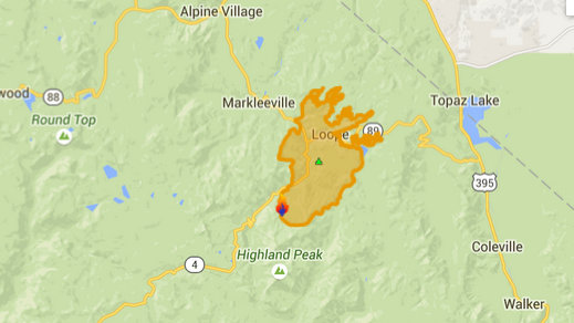
Several campgrounds along Highway 4 to the north end of Markleeville have been evacuated. In addition, Highways 4 and 89 in the Monitor Pass area are closed. Turtle Rock and Indian Creek campgrounds are closed. As a precaution, Markleeville residences have been advised to prepare for an evacuation if the need arises, however, no mandatory evacuations are in effect for Markleeville at this time.
One minor heat-related injury occurred. Once removed from the fireline, the firefighter was treated and is doing fine.
Firefighters plan to continue direct line construction north of Highway 89, as well as utilizing air and ground support. Continuing protection of cultural and historical sites within, and adjacent to the fire area will also be addressed in today's operational period. The tactical priority is to prevent the fire from reaching Markleeville, CA.
Today's weather is expected to be sunny and hazy, 81-85 degrees. Winds up slope/up valley at 5-10 mph. Ridge top winds are expected to be light in the morning. Vegetation is feeling the stress from over three years cumulative drought and historically low snow-pack in the mountains this past winter.
Smoke is dispersing to various areas surrounding the fire. Use precaution when driving, keeping in mind that visibility could be limited. Visit http://www.cdc.gov/Features/Wildfires/ for information regarding the potential effects of wildfire smoke.
Basic Information
Current as of 6/23/2015, 12:58:19 PM
Incident Type Wildfire
Cause Lightning/natural
Date of Origin Friday June 19th, 2015 approx. 07:00 PM
Location On CA Highways 4 and 89, 3 miles south of Markleeville, CA.
Incident Commander Chris Wilcox
Current Situation
Total Personnel 500
Size 16,544 Acres
Fuels Involved
Timber (Litter and Understory)
Significant Events
Active, Short Crown Runs
Outlook
Planned Actions
The primary goal this operational period is to prevent fire spread toward Markleeville.
Projected Incident Activity
Actively burning. Fuel- and slope-driven fire spread. Burning in some drainages off of the East Fork Carson River. Also spread to the north and to the east.
Remarks
Fire is burning in hazardous and inaccessible terrain and approaching an increasing number of structures and impacting travel corridors.
Current Weather
Weather Concerns
Breezy and dry conditions continue into this evening.
|
| Comments - Make a comment |
| The comments are owned by the poster. We are not responsible for its content. We value free speech but remember this is a public forum and we hope that people would use common sense and decency. If you see an offensive comment please email us at news@thepinetree.net
|
|
|


