Posted by: thepinetree on 04/21/2011 07:00 AM
Updated by: Kim_Hamilton on 04/22/2011 09:24 PM
Expires: 01/01/2016 12:00 AM
:

Winter Going Out With a Whimper?
Bear Valley, CA...Winter is still trying to hang on a bit longer with another weak series of systems rolling through. Late Afternoon: A 20 percent chance of snow. Mostly cloudy, with a steady temperature around 42. Southwest wind around 11 mph. Tonight: Snow likely. Cloudy, with a low around 28. Southwest wind between 5 and 10 mph. Chance of precipitation is 60%. New snow accumulation of 1 to 2 inches possible.....
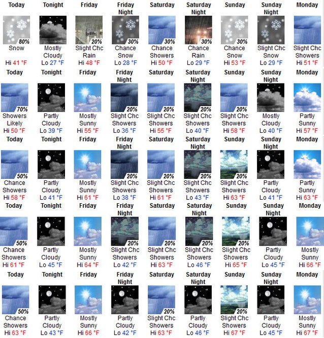
The Weather Snapshot Starts at the top in Bear Valley and includes Arnold, Murphys, Angels Camp and Copperopolis.
Saturday: A 40 percent chance of snow. Mostly cloudy, with a high near 47. South southwest wind between 6 and 11 mph, with gusts as high as 18 mph. Little or no snow accumulation expected.
Saturday Night: A 30 percent chance of snow. Mostly cloudy, with a low around 29. South southwest wind between 7 and 9 mph. Little or no snow accumulation expected.
Sunday: A 30 percent chance of snow. Partly sunny, with a high near 51. South southwest wind between 9 and 11 mph, with gusts as high as 18 mph. Little or no snow accumulation expected.
Sunday Night: A 20 percent chance of snow. Mostly cloudy, with a low around 28.
Monday: A 30 percent chance of snow. Partly sunny, with a high near 48. Little or no snow accumulation expected.
Monday Night: Partly cloudy, with a low around 29.
Tuesday: Mostly sunny, with a high near 56.
Tuesday Night: Partly cloudy, with a low around 31.
Wednesday: Mostly sunny, with a high near 59.
Wednesday Night: Partly cloudy, with a low around 33.
Thursday: Mostly sunny, with a high near 59.
Thursday Night: Partly cloudy, with a low around 30.
Friday: Mostly sunny, with a high near 54.
Hazardous Weather Outlook
THIS HAZARDOUS WEATHER OUTLOOK IS FOR INTERIOR NORTHERN CALIFORNIA.
.DAY ONE...TODAY
A WEAK WEATHER SYSTEM WILL MOVE INTO THE MOUNTAINS THIS AFTERNOON
AND INTO THE VALLEY THIS EVENING BRINGING LIGHT PRECIPITATION. LIGHT
SNOW ACCUMULATIONS ABOVE 6000 FEET ARE POSSIBLE.
.DAYS TWO THROUGH SEVEN... SATURDAY THROUGH THURSDAY
WEAK WEATHER SYSTEMS WILL MOVE THROUGH THE WEEKEND INTO MONDAY
BRINGING A THREAT OF SHOWERS. THE STRONGEST AND WETTEST OF THESE
WILL BE ON MONDAY. PRECIPITATION WILL BE MAINLY IN THE MOUNTAINS
WHERE HIGH ELEVATION SNOW MAY BRING SLIPPERY CONDITIONS.
|


