|
Posted by: thepinetree on 11/19/2014 09:17 AM
Updated by: thepinetree on 11/19/2014 09:28 AM
Expires: 01/01/2019 12:00 AM
:

Weather Forecast For The Western Slope Of The Sierras
Bear Valley, CA...Today Mostly cloudy. At lower elevations...scattered rain showers. At higher elevations...scattered rain and snow showers in the morning...then numerous rain and snow showers in the afternoon. Highs 38 to 52 higher elevations...48 to 58 lower elevations. Little or no snow accumulation. Snow level 6000 feet. Prevailing south winds up to 15 mph...except southwest 20 to 30 mph over ridges. Tonight Mostly cloudy. At lower elevations...a chance of rain showers in the evening...then a slight chance of rain showers after midnight. At higher elevations...rain and snow showers likely in the evening...then a slight chance of rain and snow showers after midnight. Colder. Lows 26 to 40 higher elevations... 36 to 46 lower elevations. Little or no snow accumulation. Snow level 7500 feet. Prevailing south winds up to 10 mph. Over ridges...prevailing southwest winds 20 to 35 mph decreasing to 15 to 25 mph after midnight...
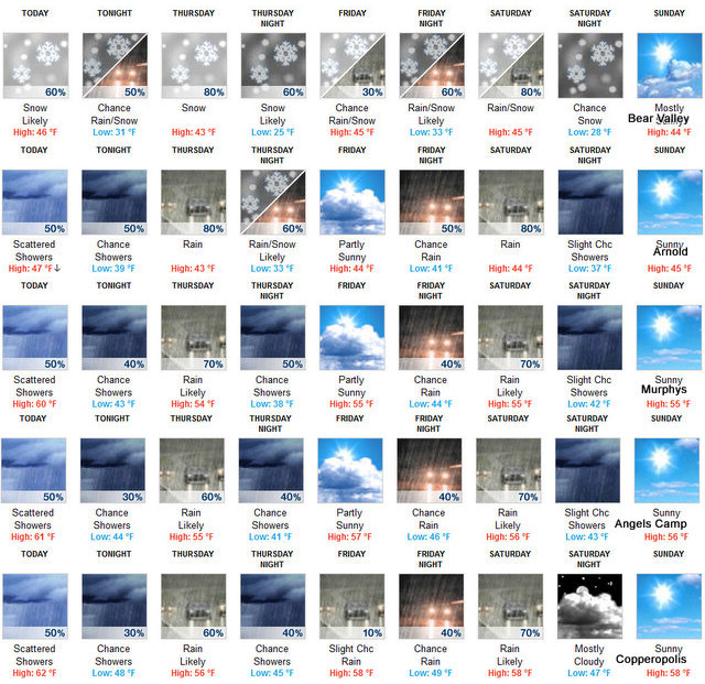
Thursday Mostly cloudy. At lower elevations...a chance of rain in the morning...then rain in the afternoon. At higher elevations...a chance of rain and snow in the morning...then rain and snow in the afternoon. Highs 34 to 48 higher elevations... 42 to 54 lower elevations. Snow accumulation up to 1 inch higher elevations. Snow level 7500 feet decreasing to 6500 feet in the afternoon. Prevailing southwest winds up to 15 mph. Over ridges... Prevailing southwest winds 5 to 15 mph increasing to 15 to 30 mph in the afternoon.
Thursday Night Mostly cloudy. Rain and snow showers likely in the evening...then a slight chance of rain and snow showers after midnight. Colder. Lows 22 to 34 higher elevations...30 to 40 lower elevations. Snow accumulation up to 1 inch higher elevations. Snow level 5000 feet. Prevailing southwest winds up to 10 mph in the evening becoming light. Over ridges...prevailing southwest winds 15 to 25 mph becoming west up to 10 mph after midnight.
Friday Mostly cloudy. A slight chance of rain in the afternoon. Highs 37 to 49 higher elevations...45 to 53 lower elevations. Snow level 6000 feet. Prevailing east winds up to 10 mph in the morning becoming light.
Friday Night Mostly cloudy with a chance of rain and snow. Lows 31 to 46.
Saturday Rain and snow. Light snow accumulations possible. Highs 38 to 53.
Saturday Night Mostly cloudy with a chance of rain and snow showers. Colder. Lows 27 to 42.
Sunday Through Monday Night Mostly clear. Highs 40 to 55. Lows 27 to 42.
Tuesday Mostly sunny. Not as cool. Highs 48 to 63.
|
| Comments - Make a comment |
| The comments are owned by the poster. We are not responsible for its content. We value free speech but remember this is a public forum and we hope that people would use common sense and decency. If you see an offensive comment please email us at news@thepinetree.net
|
| What's Related |
| These might interest you as well
Local News
Photo Albums
phpws Business Directory
Calendar
Link Manager
Web Pages
|
|
|


