| Coming Soon... |
| Friday, Apr 19 |
| All Day | Tickets on Sale Now for "You're a Good Man, Charlie Brown!" |
| Saturday, Apr 20 |
| All Day | Tickets on Sale Now for "You're a Good Man, Charlie Brown!" |
| All Day | The 7th Annual Crafty Chicks Spring Market |
| All Day | Big Plans at Big Trees State Park for Earth Day! |
| All Day | The Big Used XC Ski Sale Starts April 20th at Bear Valley Adventure Company! |
| All Day | Huge Savings at Millworkz Inventory Reduction Sale Every Saturday! |
| 09:00 AM | Spring Cleaning Time at Shred Fest 2024 on April 20th |
| 01:00 PM | Celebration of Life for Robyn Victoria Williams |
| 05:00 PM | Fundraiser Dinner at VFW San Andreas |
| Sunday, Apr 21 |
| All Day | Tickets on Sale Now for "You're a Good Man, Charlie Brown!" |
| All Day | Big Plans at Big Trees State Park for Earth Day! |
| All Day | The Big Used XC Ski Sale Starts April 20th at Bear Valley Adventure Company! |
| All Day | Our Sunday Edition with Local Features, Local Specials & More Every Sunday All Day Long! |
| 09:00 AM | Get Ready to Run in the 2024 Mr. Frog's Wild Run on April 21st. |
| 11:30 AM | The 11th Annual Mountain Ranch Chili Cook Off! |
| Monday, Apr 22 |
| All Day | The Big Used XC Ski Sale Starts April 20th at Bear Valley Adventure Company! |
| Tuesday, Apr 23 |
| All Day | The Big Used XC Ski Sale Starts April 20th at Bear Valley Adventure Company! |
| Wednesday, Apr 24 |
| All Day | The Big Used XC Ski Sale Starts April 20th at Bear Valley Adventure Company! |
| Thursday, Apr 25 |
| All Day | The Big Used XC Ski Sale Starts April 20th at Bear Valley Adventure Company! |
| Friday, Apr 26 |
| All Day | The Big Used XC Ski Sale Starts April 20th at Bear Valley Adventure Company! |
| All Day | HCO Sledfest 2024 is April 26-28 at Bear Valley |
| Saturday, Apr 27 |
| All Day | Come Celebrate Calaveras’ Spring Wine Weekend |
| All Day | The Big Used XC Ski Sale Starts April 20th at Bear Valley Adventure Company! |
| All Day | HCO Sledfest 2024 is April 26-28 at Bear Valley |
| All Day | Huge Savings at Millworkz Inventory Reduction Sale Every Saturday! |
| Sunday, Apr 28 |
| All Day | Come Celebrate Calaveras’ Spring Wine Weekend |
| All Day | The Big Used XC Ski Sale Starts April 20th at Bear Valley Adventure Company! |
| All Day | HCO Sledfest 2024 is April 26-28 at Bear Valley |
| All Day | Our Sunday Edition with Local Features, Local Specials & More Every Sunday All Day Long! |
|
|
Posted by: John_Hamilton on 12/21/2012 05:24 PM
Updated by: John_Hamilton on 12/21/2012 05:35 PM
Expires: 01/01/2017 12:00 AM
:

The Next Storm System is Starting Winter Off White! Obligatory Warnings and Hazardous Outlooks Enclosed as Well
Bear Valley, CA...The next storm system is upon us now. It looks like it will be bringing a White Christmas all the way to Christmas. Then you can unpack all your snow toys and go play. On a serious note. Please be prepared for at least a couple of days if your car gets stuck or stranded. The forecast through Christmas. Today... Late Afternoon Rain and snow showers. Snow level 4500 feet. Steady temperature around 37. Southeast wind around 13 mph, with gusts as high as 21 mph. Chance of precipitation is 100%. Little or no snow accumulation expected. Tonight Rain and snow. Snow level 4400 feet. Steady temperature around 36. Southeast wind 11 to 15 mph, with gusts as high as 23 mph. Chance of precipitation is 100%. Little or no snow accumulation expected. Saturday Rain showers before 5pm, then rain and snow showers. Some thunder is also possible. Snow level 4700 feet. Temperature falling to around 31 by noon. South southeast wind 14 to 16 mph, with gusts as high as 24 mph. Chance of precipitation is 100%. Little or no snow accumulation expected...
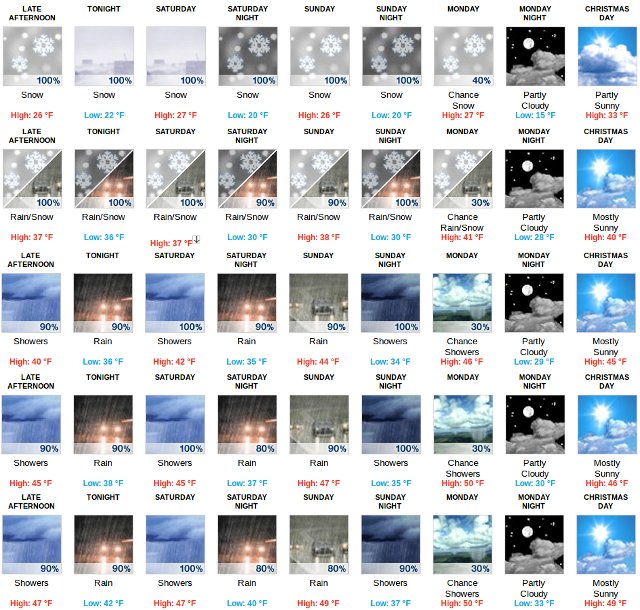
The Graphic Above Starts at Bear Valley and drops to Arnold, Murphys, Angels Camp and Copperopolis. Our hope is it will give a quick weather indicator by elevation.
Saturday Night Rain and snow, becoming all snow after 5am. Snow level 4300 feet. Low around 30. South southeast wind around 14 mph, with gusts as high as 21 mph. Chance of precipitation is 90%. New snow accumulation of less than a half inch possible.
Sunday Snow before 11am, then rain. Snow level rising to 4900 feet. High near 38. South southeast wind 8 to 18 mph, with gusts as high as 28 mph. Chance of precipitation is 90%. New snow accumulation of around an inch possible.
Sunday Night Rain showers before 11pm, then rain and snow showers. Snow level 5400 feet lowering to 4300 feet. Low around 30. Chance of precipitation is 100%. Little or no snow accumulation expected.
Monday A chance of rain and snow showers, mainly before 11am. Snow level 4200 feet. Mostly sunny, with a high near 41. Chance of precipitation is 30%. Little or no snow accumulation expected.
Monday Night Partly cloudy, with a low around 28.
Christmas Day Mostly sunny, with a high near 40.
Tuesday Night A slight chance of rain. Mostly cloudy, with a low around 35.
Wednesday A chance of rain. Partly sunny, with a high near 39.
Wednesday Night Rain and snow likely. Snow level 4500 feet. Mostly cloudy, with a low around 33.
Thursday A chance of snow showers. Mostly cloudy, with a high near 40.
Thursday Night A slight chance of rain and snow showers. Snow level 4300 feet. Mostly cloudy, with a low around 30.
Friday A slight chance of snow showers. Mostly sunny, with a high near 40.
Winter Storm Warning
URGENT - WINTER WEATHER MESSAGE
NATIONAL WEATHER SERVICE SACRAMENTO CA
220 PM PST FRI DEC 21 2012
...PERIODS OF HEAVY SNOW WILL CONTINUE IN THE MOUNTAINS OF
INTERIOR NORTHERN CALIFORNIA THROUGH THE WEEKEND...
.ADDITIONAL PACIFIC STORMS WILL TRACK ACROSS INTERIOR NORTHERN
CALIFORNIA THROUGH THE WEEKEND BRINGING MORE SNOW IN THE MOUNTAINS
AND UPPER FOOTHILLS. IN SHASTA COUNTY...SNOW LEVELS WILL AROUND
500 FEET TONIGHT INTO SATURDAY MORNING THEN RISE SATURDAY INTO
SUNDAY TO 2000 TO 3000 FEET. OVER THE WEST SLOPES OF THE NORTHERN
SIERRA NEVADA...SNOW LEVELS ARE FORECAST TO BE 3000 TO 4500 FEET
THROUGH SUNDAY. ADDITIONAL SNOW ACCUMULATIONS OF 1 TO 5 FEET ARE
POSSIBLE OVER THE HIGHER MOUNTAIN TERRAIN THROUGH THE WEEKEND.
DRIER WEATHER IS EXPECTED EARLY NEXT WEEK.
CAZ069-221200-
/O.EXT.KSTO.WS.W.0014.000000T0000Z-121224T0600Z/
WEST SLOPE NORTHERN SIERRA NEVADA-
220 PM PST FRI DEC 21 2012
...WINTER STORM WARNING NOW IN EFFECT UNTIL 10 PM PST SUNDAY
ABOVE 4000 FEET...
* SNOW ACCUMULATIONS: 2 TO 5 FEET.
* TIMING: PERIODS OF MODERATE TO HEAVY SNOW THROUGH SUNDAY.
* VISIBILITIES: ONE QUARTER MILE OR LESS AT TIMES.
* LOCATIONS INCLUDE: INTERSTATE 80 AND AREA HIGHWAYS.
* WINDS: SOUTH 15 TO 25 MPH WITH GUSTS UP TO 55 MPH.
* IMPACTS: SNOW WILL LIKELY IMPACT TRAVEL ON AREA HIGHWAYS SUCH
AS ALL TRANS SIERRA NEVADA HIGHWAY PASSES.
PRECAUTIONARY/PREPAREDNESS ACTIONS...
A WINTER STORM WARNING FOR HEAVY SNOW MEANS SEVERE WINTER WEATHER
CONDITIONS ARE EXPECTED OR OCCURRING. SIGNIFICANT AMOUNTS OF
SNOW ARE FORECAST THAT WILL MAKE TRAVEL DANGEROUS. ONLY TRAVEL IN
AN EMERGENCY. IF YOU MUST TRAVEL...KEEP AN EXTRA FLASHLIGHT...
FOOD...AND WATER IN YOUR VEHICLE IN CASE OF AN EMERGENCY.
&&
$$
Hazardous Weather Outlook
HAZARDOUS WEATHER OUTLOOK
NATIONAL WEATHER SERVICE SACRAMENTO CA
700 AM PST FRI DEC 21 2012
CAZ013>019-063-064-066>069-221500-
SHASTA LAKE AREA/NORTHERN SHASTA COUNTY-
BURNEY BASIN/EASTERN SHASTA COUNTY-NORTHERN SACRAMENTO VALLEY-
CENTRAL SACRAMENTO VALLEY-SOUTHERN SACRAMENTO VALLEY-
CARQUINEZ STRAIT AND DELTA-NORTHERN SAN JOAQUIN VALLEY-
MOUNTAINS SOUTHWESTERN SHASTA TO NORTHERN LAKE COUNTIES-
CLEAR LAKE/SOUTHERN LAKE COUNTY-MOTHERLODE-
EAST FOOTHILLS/NORTH SACRAMENTO VALLEY-
WESTERN PLUMAS COUNTY/LASSEN PARK-WEST SLOPE NORTHERN SIERRA NEVADA-
700 AM PST FRI DEC 21 2012
THIS HAZARDOUS WEATHER OUTLOOK IS FOR INTERIOR NORTHERN CALIFORNIA.
.DAY ONE...TODAY
A MAJOR WINTER STORM IMPACTS INTERIOR NORTHERN CALIFORNIA UP TO 2
FOOT OF SNOW ABOVE 2500 FEET IN THE SHASTA COUNTY MOUNTAINS WITH
NEAR A FOOT OVER INTERSTATE 5. THE NORTHERN SIERRA NEVADA COULD SEE
UP TO 2 FEET OF SNOW ABOVE 3500 TO 4000 FEET. BREEZY TO STRONG WINDS
WILL CONTINUE TODAY.
* WINTER STORM WARNING.......SEE WWUS46 KSTO - WSWSTO FOR DETAILS *
.DAYS TWO THROUGH SEVEN... SATURDAY THROUGH THURSDAY
TWO MORE WAVES PASS THROUGH INTERIOR NORTHERN CALIFORNIA THROUGH THE
WEEKEND AND COULD BRING 2 TO 3 FEET OF SNOW OVER THE SHASTA COUNTY
MOUNTAINS AND 3 TO 6 FEET OF SNOW OVER THE WEST SLOPE OF THE
NORTHERN SIERRA NEVADA. BREEZY TO STRONG WINDS WILL CONTINUE THROUGH
THE WEEKEND.
* WINTER STORM WARNING.......SEE WWUS46 KSTO - WSWSTO FOR DETAILS *
.SPOTTER INFORMATION STATEMENT...
WEATHER SPOTTERS ARE ENCOURAGED TO REPORT SIGNIFICANT WEATHER
CONDITIONS TO THEIR LOCAL NATIONAL WEATHER SERVICE OFFICE.
THE LATEST WEATHER INFORMATION IS AVAILABLE ON THE INTERNET AT
(LOWER CASE): HTTP://WWW.WRH.NOAA.GOV/STO
$$
JCLAPP
|
| Comments - Make a comment |
| The comments are owned by the poster. We are not responsible for its content. We value free speech but remember this is a public forum and we hope that people would use common sense and decency. If you see an offensive comment please email us at news@thepinetree.net
|
| What's Related |
| These might interest you as well
Photo Albums
phpws Business Directory
Local News
Calendar
Link Manager
Web Pages
|
|
|


